Toggle navigation
LMEC Home
Exhibitions
Georeferencing
Tools for Teachers
Collections
My Favorites
Sign Up / Log In
Search
Search the map portal
Map Collection
Map Collection
Map Sets
Search
Search
Search for
Search In
All Fields
Creator
Title
Subject
Place
Search All Digital Collections
Advanced Search
136 Results
My Search
Start Over
1772
Remove constraint 1772
Filter your Search
Place
North and Central America
91
United States
32
Canada
24
New France
10
Haiti
9
New York
9
North America
9
Hispaniola
7
more
Place
»
Topic
Canada--Maps--Early works to 1800
10
Haiti--Maps--Early works to 1800
7
Hispaniola--Maps--Early works to 1800
7
New France--Maps
7
Cape Verde--Maps--Early works to 1800
6
Africa, West--Maps--Early works to 1800
5
North America--Maps
5
Great Lakes (North America)--Maps
4
more
Topic
»
Date
Date range begin
–
Date range end
Current results range from
1738
to
1919
View distribution
Creator
Bellin, Jacques Nicolas, 1703-1772
88
Sayer, Robert, 1725-1794
4
Andrews, Peter, active 1765-1782
3
De Brahm, John Gerar William, 1717-ca. 1799
3
Robert de Vaugondy, Didier, 1723-1786
3
Amherst, Jeffery Amherst, Baron, 1717-1797
2
Bowen, Emanuel, d. 1767
2
Carey, Mathew, 1760-1839
2
more
Creator
»
Format
Maps/Atlases
135
Manuscripts
9
Prints
1
Georeferenced
Yes
3
No
133
Collection
American Revolutionary War-Era Maps
102
Norman B. Leventhal Map Center Collection
61
William L. Clements Library Collection
38
Maritime Charts and Atlases
15
American Antiquarian Society Collection
10
Library and Archives Canada Collection
8
Mapping Boston Collection
6
Boston and New England Maps
5
more
Collection
»
Available to use
No known restrictions
56
Creative Commons license
19
Search Constraints
Sort by relevance
relevance
title
date (asc)
date (desc)
Number of results to display per page
20 per page
10
per page
20
per page
50
per page
100
per page
View results as:
grid view
map view
Search Results
101.
An accurate map of North America : describing and distinguishing the British and Spanish dominions on this great continent :...
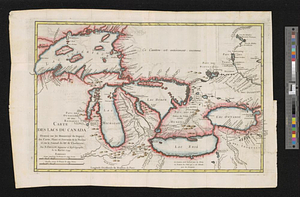
102.
Carte des lacs du Canada dressée sur les manuscrits du Depost des Cartes, Plans et Journaux de la Marine et sur le journal du...
103.
La rivière du Détroit depuis le Lac Sainte Claire jusqu'au Lac Erié
104.
The states of Maryland and Delaware from the latest surveys, 1799
105.
America Meridionalis concinata juxta observationes Dun Acad. Regalis Scientiarum et nonnullorum aliorum
106.
A map of part of West Florida done under the direction of the honourable John Stuart esqr: & by him humbly inscribed to his...
107.
Carte de la Louisiane et des pays voisins : dédiée à M. Rouillé, sécretaire d'État, ayant le Département de la marine
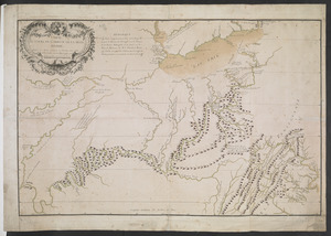
108.
Carte des découvertes qui ont été faites dans la partie occidentale du Canada sur les mémoires de Mr de la Varanderie [Vérendrye]
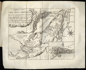
109.
Karte von der Insel Montreal und den gegenden umher, nach den manuscripten der karten, grundrisse und tagebücher beÿ der...
110.
The Ancient Tegesta, now promontory of East Florida
111.
Chart of the South End of East Florida and Martiers
112.
Hydrographical map of the Atlantic Ocean, extending from the southermost part of North America to Europe : Shewing the differt....
113.
A new chart of America with the harbors of New York, Boston, &c
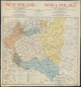
114.
New Poland = Nowa Polska
115.
CARTE DU COURS DE L'OHIO OU DE LA BELLE RIVIERE : Depuis sa Source jusqu'a sa Jonction avec celle d'Ouabache, avec les pays les...
116.
North America
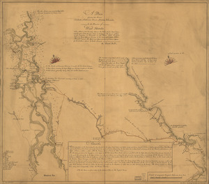
117.
A plan of part of the rivers Tombecbe, Alabama, Tensa, Perdido, & Scambia in the province of West Florida : with a sketch of...
118.
A New and accurate map of the province of South Carolina in North America
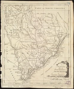
119.
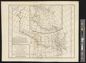
Carte de la Californie et des pays nord-ouest separés de l'Asie par le détroit d'Anian, extraite de deux cartes publiées au...
120.
Copy of a plan of the river Iberville from Lake Maurepas to the forks, with part of the Comit and Amit : taken from engineer...
‹ Prev
Next ›
1
2
3
4
5
6
7


![Carte des découvertes qui ont été faites dans la partie occidentale du Canada sur les mémoires de Mr de la Varanderie [Vérendrye]](https://bpldcassets.blob.core.windows.net/derivatives/images/commonwealth:wp98ck41z/image_thumbnail_300.jpg)