Toggle navigation
LMEC Home
Exhibitions
Georeferencing
Tools for Teachers
Collections
My Favorites
Sign Up / Log In
Search
Search the map portal
Map Collection
Map Collection
Map Sets
Search
Search
Search for
Search In
All Fields
Creator
Title
Subject
Place
Search All Digital Collections
Advanced Search
426 Results
My Search
Start Over
pennsylvania
Remove constraint pennsylvania
Filter your Search
Place
North and Central America
421
United States
375
Pennsylvania
236
Philadelphia
54
Philadelphia (county)
54
Maryland
36
New Jersey
34
New York
34
more
Place
»
Topic
Pennsylvania--Maps
51
Pennsylvania--Maps--Early works to 1800
27
Philadelphia (Pa.)--Maps
19
Maryland--Maps
18
United States--History--Revolution, 1775-1783--Maps
17
Virginia--Maps
16
New Jersey--Maps--Early works to 1800
14
United States--History--French and Indian War, 1754-1763--Maps
14
more
Topic
»
Date
Date range begin
–
Date range end
Current results range from
1689
to
1972
View distribution
Creator
O.H. Bailey & Co
19
George, III, King of Great Britain, 1738-1820
15
George, IV, King of Great Britain, 1762-1830
14
Mitchell, S. Augustus, (Samuel Augustus), Jr
14
Royal United Services Institute for Defence and Security Studies
14
Fisk, E. F.
13
International Correspondence Schools
13
International Textbook Company
13
more
Creator
»
Format
Maps/Atlases
417
Manuscripts
50
Books
4
Photographs
3
Drawings/Illustrations
2
Georeferenced
Yes
36
No
390
Collection
Norman B. Leventhal Map & Education Center Collection
245
American Revolutionary War-Era Maps
215
William L. Clements Library Collection
64
Urban Maps
48
British Library Collection
34
Library of Congress Collection
30
Richard H. Brown Revolutionary War Map Collection at Mount Vernon
20
New York Public Library Collection
13
more
Collection
»
Available to use
No known restrictions
245
Creative Commons license
107
Search Constraints
Sort by relevance
relevance
title
date (asc)
date (desc)
Number of results to display per page
20 per page
10
per page
20
per page
50
per page
100
per page
View results as:
grid view
map view
Search Results
81.
A survey of the empire group : with a complete distance table, a compendious index of cities and post offices, with populations...
82.
A map of the provinces of New-York and New Jersey, with a part of Pennsylvania and the Province of Quebec
83.
Lord Baltimore's own plan : proposed Maryland/Pennsylvania boundary
84.
Exact plan of General Gage's lines on Boston Neck in America
85.
Part of the modern counties of Philadelphia, Bucks, Montgomery, Delaware, Chester, and Lancaster in Pennsylvania; New Castle in...
86.
Part of the modern counties of Monmouth, Middlesex, Somerset, Hunterdon, Mercer, Burlington, and Ocean in New Jersey and...
87.
Draught of a tract of land situate in Bucks County, in the Commonwealth of Pennsylvania divided in three parts, called...
88.
A new map of the English empire in America viz. Virginia, Maryland, Carolina, Pennsylvania, New York, New Iarsey, New England,...
89.
Tri-state power map : Pennsylvania -- New York -- New Jersey
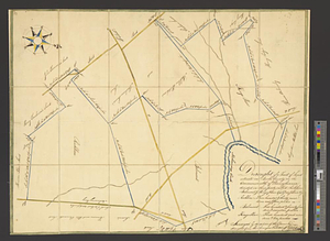
90.
A map of the farm and a draught of the buildings thereon, in West-town Township, Chester Co. Pennsylvania, belonging to the...
91.
Post route map of the state of Pennsylvania showing post offices and the intermediate distances on mail routes in operation on...
92.
Post route map of the state of Pennsylvania showing post offices with the intermediate distances on mail routes in operation on...
93.
A New and accurate map of Virginia : and part of Maryland and Pennsylvania
94.
Post route map of the states of Virginia and West Virginia together with Maryland and Delaware with adjacent parts of...
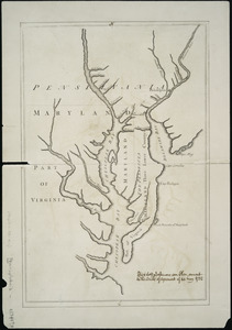
95.
[A map of part of Pennsylvania & Maryland intended to shew, at one view, the several places proposed for opening a...
96.
Colton's Georgetown and the city of Washington : the capital of the United States of America ; Colton's map showing part of...
97.
Post route map of the states of Pennsylvania, New Jersey, Delaware, and Maryland and of the District of Columbia with adjacent...
98.
Virginia, Maryland, Pennsilvania, east & west New Jarsey
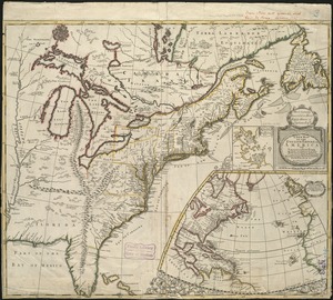
99.
A new map of part of the United States of North America, containing those of New York, Vermont, New Hampshire, Massachusets...
100.
An exact map of New Jersey, Pensylvania [sic], New York, Maryland & Virginia, from the latest surveys
‹ Prev
Next ›
1
2
3
4
5
6
7
8
9
…
21
22


![[A map of part of Pennsylvania & Maryland intended to shew, at one view, the several places proposed for opening a communication between the waters of the Delaware & Chesopeak Bays]](https://bpldcassets.blob.core.windows.net/derivatives/images/commonwealth:z603vt12v/image_thumbnail_300.jpg)


![A new map of part of the United States of North America, containing those of New York, Vermont, New Hampshire, Massachusets [sic], Connecticut, Rhode Island, Pennsylvania, New Jersey, Delaware, Maryland and Virginia](https://bpldcassets.blob.core.windows.net/derivatives/images/commonwealth:6t053p06v/image_thumbnail_300.jpg)
![An exact map of New Jersey, Pensylvania [sic], New York, Maryland & Virginia, from the latest surveys](https://bpldcassets.blob.core.windows.net/derivatives/images/commonwealth:z603vp67m/image_thumbnail_300.jpg)