Toggle navigation
LMEC Home
Exhibitions
Georeferencing
Tools for Teachers
Collections
My Favorites
Sign Up / Log In
Search
Search the map portal
Map Collection
Map Collection
Map Sets
Search
Search
Search for
Search In
All Fields
Creator
Title
Subject
Place
Search All Digital Collections
Advanced Search
98 Results
My Search
Start Over
g1105
Remove constraint g1105
Filter your Search
Place
North and Central America
85
United States
34
Canada
14
Quebec
8
South America
8
Cuba
6
North America
6
Pennsylvania
6
more
Place
»
Topic
North America--Maps--Early works to 1800
6
America--Discovery and Exploration--Maps--Early works to 1800
5
Québec (Québec)--Maps--Early works to 1800
5
Tactics--Maps--Early works to 1800
5
Braddock's Campaign, 1755--Maps
4
New England--Maps--Early works to 1800
4
United States--History--French and Indian War, 1754-1763--Maps
4
United States--History--French and Indian War, 1754-1763--Maps--Early works to 1800
4
more
Topic
»
Date
Date range begin
–
Date range end
Current results range from
1511
to
1777
View distribution
Creator
Jefferys, Thomas, -1771
76
Sayer, Robert, 1725-1794
66
Celi, Francisco Mathias
8
Le Rouge, Georges-Louis.
7
Green, John, -1757
6
Orme, Robert, -1781
6
Bellin, Jacques Nicolas, 1703-1772
2
Bully, le sieur
2
more
Creator
»
Format
Maps/Atlases
98
Georeferenced
Yes
1
No
97
Collection
Norman B. Leventhal Map & Education Center Collection
98
American Revolutionary War-Era Maps
68
Maritime Charts and Atlases
20
Boston and New England Maps
4
Urban Maps
2
Available to use
No known restrictions
98
Search Constraints
Sort by relevance
relevance
title
date (asc)
date (desc)
Number of results to display per page
20 per page
10
per page
20
per page
50
per page
100
per page
View results as:
grid view
map view
Search Results
81.
Plan of the town of Basse Terre the capital of Guadaloupe from an authentic survey
82.
Plan of the town of Cayenne and Fort St. Michael
83.
Plan of the town, road, and harbour of Chagre ; Plan of Porto Belo
84.
Plan of Zisapata Bay ; Plan of the harbour of Carthagena
85.
Port Royal appellé aujourd. par les Anglois Annapolis Royal
86.
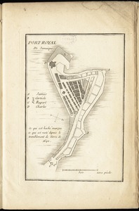
Port-Royal de Jamaique
87.
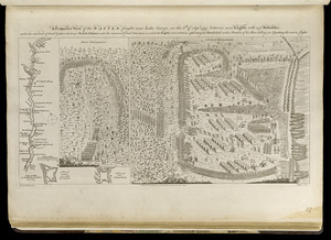
A prospective view of the battle fought near Lake George, on the 8th of Sepr. 1755, between 2000 English, with 250 Mohawks,...
88.
The provinces of New York, and New Jersey; with part of Pensilvania, and the governments of Trois Rivieres, and Montreal
89.
Sault du Niagara de 135 pieds de haut
90.
St. Christophers
91.
A survey of the coast about Cape Lookout in North Carolina, taken the 29th. of June 1756
92.
Tertia Asiae tabula
93.
To the Honourable Thomas Penn and Richard Penn, Esqrs., true & absolute proprietaries & Governours of the Province of...
94.
Tobago
95.
Vera-Cruz dans le Golfe du Méxique [and] Isle St. Juan, Fort de St. Jean d'Ulloa
96.
Vue de Quebec, capitale du Canada
97.
The West Indies exhibiting the English, French, Spanish, Dutch & Danish settlements
98.
A correct map of the coast of New England
‹ Prev
Next ›
1
2
3
4
5


![Vera-Cruz dans le Golfe du Méxique [and] Isle St. Juan, Fort de St. Jean d'Ulloa](https://bpldcassets.blob.core.windows.net/derivatives/images/commonwealth:cj82kx24p/image_thumbnail_300.jpg)


