Toggle navigation
LMEC Home
Exhibitions
Georeferencing
Tools for Teachers
Collections
My Favorites
Sign Up / Log In
Search
Search the map portal
Map Collection
Map Collection
Map Sets
Search
Search
Search for
Search In
All Fields
Creator
Title
Subject
Place
Search All Digital Collections
Advanced Search
89 Results
My Search
Start Over
1969
Remove constraint 1969
Filter your Search
Place
United States
84
North and Central America
15
Boston
10
Suffolk (county)
10
Massachusetts
4
South End
3
Lesser Antilles
2
Brookline
1
more
Place
»
Topic
United States--Maps
70
Elections--United States--Maps
33
Population density--United States--Maps
14
Suffrage--United States--Maps
6
Voting--United States--Maps
6
City planning--Massachusetts--Boston--Maps
5
Public Lands--United States--Maps
4
Women--Suffrage--United States--Maps
4
more
Topic
»
Date
Date range begin
–
Date range end
Current results range from
1730
to
1997
View distribution
Creator
Wright, John Kirtland, 1891-1969
71
Paullin, Charles Oscar, 1868 or 1869-1944
70
Boston Redevelopment Authority
8
Delarochette, L. (Louis), 1731-1802
2
Jefferys, Thomas, -1771
2
Abbe Museum
1
Boston Redevelopment Authority. Transportation Planning Department
1
Brookline (Mass.). Dept. of Public Works. Engineering Division
1
more
Creator
»
Format
Maps/Atlases
89
Georeferenced
Yes
23
No
66
Collection
Norman B. Leventhal Map Center Collection
83
Boston and New England Maps
12
Urban Maps
10
Boston Redevelopment Authority Collection
6
David Judkins Weaver Papers
2
American Revolutionary War-Era Maps
1
Richard H. Brown Revolutionary War Map Collection at Mount Vernon
1
Town plans, 1830
1
Available to use
No known restrictions
18
Creative Commons license
1
Search Constraints
Sort by date (asc)
relevance
title
date (asc)
date (desc)
Number of results to display per page
20 per page
10
per page
20
per page
50
per page
100
per page
View results as:
grid view
map view
Search Results
81.
Boston development program
82.
Illustrative site plan : South End urban renewal area, Massachusetts r-56
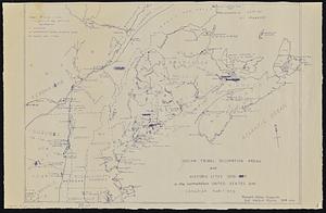
83.
Indian tribal occupation areas and historic sites 1500-1600 in the northeastern United States and Canadian Maritimes
84.
The regional open space system : [Boston, Massachusetts metropolitan area]
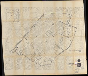
85.
South End urban renewal area R-56 : proposed rights-of-way
86.
Waterfront land inventory South Boston : CRP port study
87.
West Canton Community Park
88.
Southwest corridor restudy
89.
Tactical pilotage chart, TPC
‹ Prev
Next ›
1
2
3
4
5