Toggle navigation
LMEC Home
Exhibitions
Georeferencing
Tools for Teachers
Collections
My Favorites
Sign Up / Log In
Search
Search the map portal
Map Collection
Map Collection
Map Sets
Search
Search
Search for
Search In
All Fields
Creator
Title
Subject
Place
Search All Digital Collections
Advanced Search
2261 Results
My Search
Start Over
london
Remove constraint london
Filter your Search
Place
North and Central America
1,492
United States
943
Europe
363
Canada
347
North America
194
New York
129
Massachusetts
117
New England
104
more
Place
»
Topic
North America--Maps--Early works to 1800
137
Coasts--Nova Scotia--Maps
64
New England--Maps--Early works to 1800
57
United States--History--French and Indian War, 1754-1763--Maps
57
United States--History--French and Indian War, 1754-1763--Maps, Manuscript--Early works to 1800
56
United States--Maps--Early works to 1800
54
United States--History--Revolution, 1775-1783--Maps
40
Nova Scotia--Maps--Early works to 1800
39
more
Topic
»
Date
Date range begin
–
Date range end
Current results range from
1624
to
1999
View distribution
Creator
Des Barres, Joseph F. W. (Joseph Frederick Wallet), 1722-1824
242
Jefferys, Thomas, -1771
167
George, III, King of Great Britain, 1738-1820
149
George, IV, King of Great Britain, 1762-1830
148
Sayer, Robert, 1725-1794
115
Faden, William, 1749-1836
109
Moll, Herman, d. 1732
72
Robert Sayer and John Bennett (Firm)
57
more
Creator
»
Format
Maps/Atlases
2,219
Manuscripts
161
Prints
23
Drawings/Illustrations
15
Books
4
Objects/Artifacts
1
Georeferenced
Yes
137
No
2,124
Collection
American Revolutionary War-Era Maps
1,355
Norman B. Leventhal Map & Education Center Collection
1,305
Maritime Charts and Atlases
263
British Library Collection
163
William L. Clements Library Collection
160
Boston and New England Maps
152
Richard H. Brown Revolutionary War Map Collection at Mount Vernon
146
MacLean Collection Map Library
140
more
Collection
»
Available to use
No known restrictions
1,271
Creative Commons license
569
Search Constraints
Sort by relevance
relevance
title
date (asc)
date (desc)
Number of results to display per page
20 per page
10
per page
20
per page
50
per page
100
per page
View results as:
grid view
map view
Search Results
761.
Antigoa
762.
Barrington Bay
763.
Bowles's new pocket map of the most inhabited part of New England : comprehending the provinces of Massachusets Bay and New...
764.
Coast of Maine from Rockland Harbor to Pemaquid Point
765.
[Environs of Philadelphia]
766.
The harbours of Rishibucto & Buctush : on the west shore of the Gulph of St. Lawrence
767.
The island of Jamaica
768.
[Lennox Passage region]
769.
A map of the n.e. part of Asia, and n.w. parts of America, shewing their situations with respect to Japan
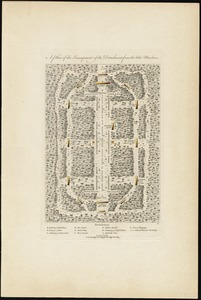
770.
A plan of the encampment of the detachment from the little Meadows
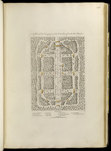
771.
A plan of the encampment of the detachment from the little Meadows
772.
Port Mills : Port Mansfield ; Gambier Harbour
773.
Port Royal in South Carolina : taken from surveys deposited at the Plantation Office
774.
[Port Shediack and Cocagne]
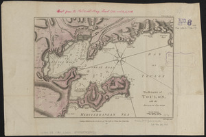
775.
The Roads of Toulon, with the adjacent country
776.
To the Right Honourable the Master, Wardens, & Elder Bretham of the Trinity House, this chart of the entrances to The River...
777.
Yggdrasill, the mundane tree
778.
A map of the United States of America, as settled by the peace of 1783
779.
Map second division railway mail service
780.
Northern Africa
‹ Prev
Next ›
1
2
…
35
36
37
38
39
40
41
42
43
…
113
114


![[Environs of Philadelphia]](https://bpldcassets.blob.core.windows.net/derivatives/images/commonwealth:7h149x76d/image_thumbnail_300.jpg)


![[Lennox Passage region]](https://bpldcassets.blob.core.windows.net/derivatives/images/commonwealth:ws859h17t/image_thumbnail_300.jpg)


![[Port Shediack and Cocagne]](https://bpldcassets.blob.core.windows.net/derivatives/images/commonwealth:ws859h35r/image_thumbnail_300.jpg)