Toggle navigation
LMEC Home
Exhibitions
Georeferencing
Tools for Teachers
Collections
My Favorites
Sign Up / Log In
Search
Search the map portal
Map Collection
Map Collection
Map Sets
Search
Search
Search for
Search In
All Fields
Creator
Title
Subject
Place
Search All Digital Collections
Advanced Search
14164 Results
Filter your Search
Place
North and Central America
10,832
United States
8,868
Massachusetts
2,832
Suffolk (county)
1,688
Boston
1,644
Europe
1,428
Canada
1,010
New York
684
more
Place
»
Topic
Boston (Mass.)--Maps
753
City planning--Massachusetts--Boston--Maps
419
United States--History--Revolution, 1775-1783--Maps
331
United States--Maps
331
Real property--Massachusetts--Boston--Maps
254
Urban renewal--Massachusetts--Boston--Maps
254
North America--Maps--Early works to 1800
241
Massachusetts--Maps
236
more
Topic
»
Date
Date range begin
–
Date range end
Current results range from
1482
to
2023
View distribution
Creator
United States. Hydrographic Office
597
Boston Redevelopment Authority
404
Des Barres, Joseph F. W. (Joseph Frederick Wallet), 1722-1824
247
Jefferys, Thomas, -1771
172
United States. National Ocean Service
170
Royal United Services Institute for Defence and Security Studies
160
George, III, King of Great Britain, 1738-1820
152
George, IV, King of Great Britain, 1762-1830
151
more
Creator
»
Format
Maps/Atlases
13,978
Manuscripts
985
Prints
102
Books
53
Drawings/Illustrations
44
Photographs
15
Objects/Artifacts
13
Documents
7
more
Format
»
Georeferenced
Yes
979
No
13,185
Collection
Norman B. Leventhal Map & Education Center Collection
9,162
American Revolutionary War-Era Maps
3,629
Boston and New England Maps
2,936
Urban Maps
2,511
Maritime Charts and Atlases
1,169
William L. Clements Library Collection
910
Library of Congress Collection
618
Boston Redevelopment Authority Collection
475
more
Collection
»
Available to use
No known restrictions
10,408
Creative Commons license
1,678
Search Constraints
Sort by relevance
relevance
title
date (asc)
date (desc)
Number of results to display per page
20 per page
10
per page
20
per page
50
per page
100
per page
View results as:
grid view
map view
Search Results
6061.
Map of the county of Berkshire, Massachusetts : based upon the trigonometrical survey of the state
6062.
Map of the county of Bristol, Massachusetts : based upon the trigonometrical survey of the state
6063.
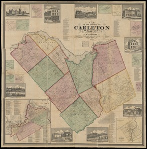
Map of the county of Carleton, Canada West : from surveys under the direction of H.F. Walling
6064.
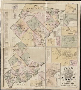
Map of the county of Essex, Vermont
6065.
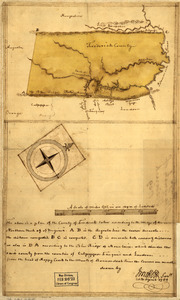
Map of the county of Frederick, 1769
6066.
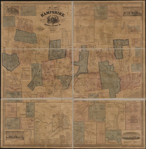
Map of the county of Hampshire, Massachusetts : based upon the trigonometrical survey of the state
6067.
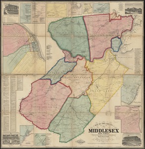
Map of the County of Middlesex, New Jersey
6068.
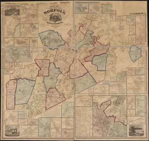
Map of the county of Norfolk, Massachusetts : based upon the trigonometrical survey of the state
6069.
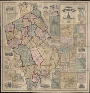
Map of the county of Plymouth, Massachusetts : from actual surveys under the direction of Henry F. Walling
6070.
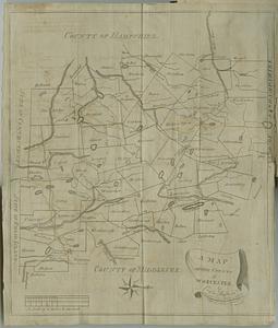
A map of the county of Worcester
6071.
A map of the Delaware and Chesapeak bays with the peninsula between them
6072.
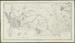
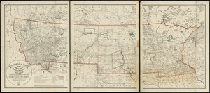
Map of the Department of Dakota including Minnesota, Dakota and Montana
6073.
Map of the Department of Dakota including Minnesota, North Dakota, Montana, Yellowstone National Park, and that portion of...
6074.
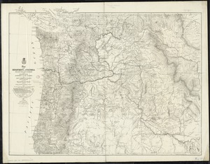
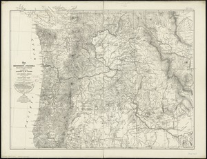
Map of the Department of the Columbia
6075.
Map of the Department of the Columbia
6076.
Map of the Diocese of Massachusetts showing the location of the Episcopal parishes and Missionary Stations
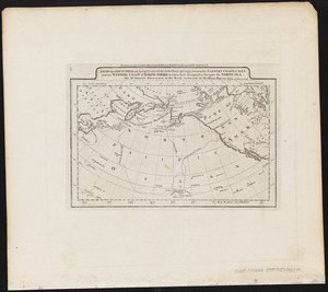
6077.
A map of the discoveries made by Capts. Cook & Clerke in the years 1778 & 1779 between the eastern coast of Asia and the...
6078.
A map of the discoveries made by the Russians on the North West coast of America
6079.
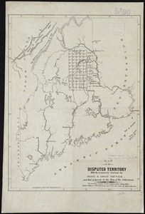
Map of the disputed territory [Maine] : reduced from the original of Messrs. Featherstonehaugh & Mudge, British commissioners
6080.
Map of the disputed territory with the boundaries claimed by Maine & Great Britain and that proposed by the King of the...
‹ Prev
Next ›
1
2
…
300
301
302
303
304
305
306
307
308
…
708
709


![Map of the disputed territory [Maine]](https://bpldcassets.blob.core.windows.net/derivatives/images/commonwealth:7h14b025h/image_thumbnail_300.jpg)