Toggle navigation
LMEC Home
Exhibitions
Georeferencing
Tools for Teachers
Collections
My Favorites
Sign Up / Log In
Search
Search the map portal
Map Collection
Map Collection
Map Sets
Search
Search
Search for
Search In
All Fields
Creator
Title
Subject
Place
Search All Digital Collections
Advanced Search
107 Results
My Search
Start Over
new brunswick
Remove constraint new brunswick
Filter your Search
Place
North and Central America
87
Canada
80
Province of New Brunswick
35
United States
28
Maine
16
Nova Scotia
12
Saint John
9
Fort Beauséjour National Historic Park
8
more
Place
»
Topic
New Brunswick--Maps
9
Maine--Maps
7
Canada--Boundaries--United States--Maps
6
Coasts--New Brunswick--Maps
6
Fort Cumberland (N.B.)--Maps, Manuscript--Early works to 1800
6
New Brunswick--Maps--Early works to 1800
6
New England--Maps
6
Nova Scotia--Maps
6
more
Topic
»
Date
Date range begin
–
Date range end
Current results range from
1662
to
1992
View distribution
Creator
Amherst, Jeffery Amherst, Baron, 1717-1797
9
Royal United Services Institute for Defence and Security Studies
9
Des Barres, Joseph F. W. (Joseph Frederick Wallet), 1722-1824
8
George, III, King of Great Britain, 1738-1820
8
George, IV, King of Great Britain, 1762-1830
8
Bruce, Robert George
7
Parr, John, 1725-1791
6
United States. Hydrographic Office
6
more
Creator
»
Format
Maps/Atlases
107
Manuscripts
16
Objects/Artifacts
1
Georeferenced
Yes
5
No
102
Collection
Norman B. Leventhal Map Center Collection
59
American Revolutionary War-Era Maps
56
British Library Collection
17
Boston and New England Maps
13
Maritime Charts and Atlases
11
Library of Congress Collection
10
Urban Maps
10
William L. Clements Library Collection
9
more
Collection
»
Available to use
No known restrictions
58
Creative Commons license
33
Search Constraints
Sort by title
relevance
title
date (asc)
date (desc)
Number of results to display per page
20 per page
10
per page
20
per page
50
per page
100
per page
View results as:
grid view
map view
Search Results
41.
Map of the state of Maine : exhibiting the disputed territory in connexion with the adjacent British provinces of N. Brunswick...
42.
Map of the state of Maine with the province of New Brunswick
43.
A MAP OF THE SURVEYED PARTS OF NOVA SCOTIA MDCCLVI
44.
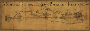
A Map of the Trenton and New-Brunswick Turnpike-road
45.
A map of the United States and Canada, New-Scotland, New-Brunswick and New-Foundland = Carte des Etats-Unis avec le Canada, la...
46.
Map of the United States of North America, upper & lower Canada, New Brunswick, Nova Scotia & British Columbia, Mexico, Cuba,...
47.
Map showing land grants to the east of St. John
48.
Map showing the number of chartered banks in New Brunswick, Nova Scotia, and Prince Edward Island
49.
McMillan's map of New Brunswick, 1867
50.
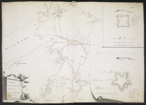
Miramichi Bay
51.
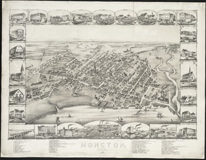
Moncton : New Brunswick
52.
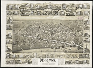
Moncton, New Brunswick
53.
A new & exact map of the electorate of Brunswick-Lunenburg and ye rest of ye Kings dominions in Germany : very much improved by...
54.
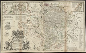
A new and accurate map of the province of Nova Scotia, in North America; from the latest observations
55.
A new and correct chart of the coast of New England and New York with the adjacent parts of Nova Scotia and New Brunswick from...
56.
A New and correct map of the British colonies in North America comprehending eastern Canada with the province of Quebec, New...
57.
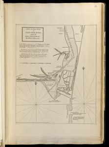
A new and exact plan of Cape Fear River, from the bar to Brunswick
58.
New Brunswick, Nova Scotia, Newfoundland, and Prince Edward Id.
59.
A new chart of ye coast of New Found Land, New Scotland and New England &c.
60.
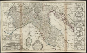
A new map of the upper part of Italy containing ye principality of Piemont ye Dutchies of Savoy, Milan, Parma, Mantua, Modena,...
‹ Prev
Next ›
1
2
3
4
5
6