Toggle navigation
LMEC Home
Exhibitions
Georeferencing
Tools for Teachers
Collections
My Favorites
Sign Up / Log In
Search
Search the map portal
Map Collection
Map Collection
Map Sets
Search
Search
Search for
Search In
All Fields
Creator
Title
Subject
Place
Search All Digital Collections
Advanced Search
54 Results
My Search
Start Over
1924
Remove constraint 1924
Filter your Search
Place
North and Central America
41
United States
39
Massachusetts
8
Europe
7
France
7
Boston
6
Suffolk (county)
6
Asia
5
more
Place
»
Topic
Boston (Mass.)--Maps
4
Fire risk assessment
4
Insurance surveys
4
Cotton manufacture
2
Intrenchments--France--Verdun--Maps
2
Landowners--Massachusetts--Boston--Maps
2
Landowners--Massachusetts--Lynn--Maps
2
Landowners--Massachusetts--Nahant--Maps
2
more
Topic
»
Date
Date range begin
–
Date range end
Current results range from
1800
to
1932
View distribution
Creator
United States. Army. Engineer Reproduction Plant
6
France. Armée. Groupe de canevas de tir
5
United States. Army. Army, 2nd
5
Comey, Arthur C. (Arthur Coleman), 1886-1954
3
Geological Survey (U.S.)
3
Rand McNally and Company
3
Richards Map Company
3
Associated Factory Mutual Fire Insurance Companies
2
more
Creator
»
Format
Maps/Atlases
54
Georeferenced
No
54
Collection
Norman B. Leventhal Map & Education Center Collection
41
Boston and New England Maps
12
Urban Maps
11
American Textile History Museum Image Collection
4
Massachusetts Real Estate Atlases
3
David Judkins Weaver Papers
2
Lucius Beebe Memorial Library Historic Maps
2
Boston Redevelopment Authority Collection
1
more
Collection
»
Available to use
No known restrictions
45
Search Constraints
Sort by relevance
relevance
title
date (asc)
date (desc)
Number of results to display per page
20 per page
10
per page
20
per page
50
per page
100
per page
View results as:
grid view
map view
Search Results
41.
Atlas of the city of Boston : West Roxbury
42.
Atlas of the city of Boston : West Roxbury : from actual surveys and official plans
43.
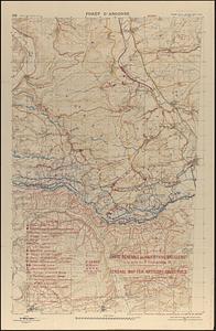
Carte générale des objectifs d'artillerie a la date du 24 Août 1918 = General map for artillery objectives up to the of 24th...
44.
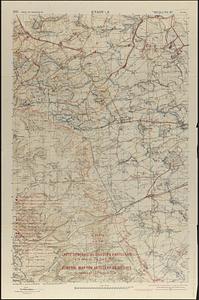
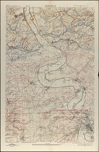
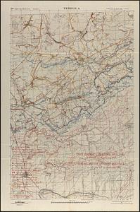
Carte générale des objectifs d'artillerie à la date du 9 Septembre 18 = General map for artillery objectives up to the 9th...
45.
Carte générale des objectifs d'artillerie à la date du 9 Septembre 1918 = General map for artillery objectives up to the 9th...
46.
Carte générale des objectifs d'artillerie à la date du 9 Septembre 1918 = General map for artillery objectives up to the 9th...
47.
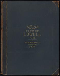
Richards standard atlas of the city of Lowell, Massachusetts
48.
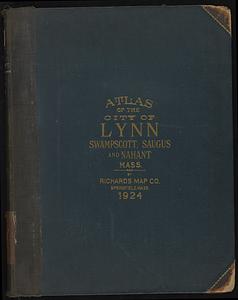
Richards standard atlas of the city of Lynn and the towns of Swampscott, Saugus, and Nahant, Massachusetts
49.
St. Mihiel - B
50.
Erez Israel = Erets Yiśraʼel : adamah ʻIvrit
51.
Street index map of Oakland, Albany, Berkeley, Emeryville, Piedmont, Alameda, San Leandro, Alameda Co., California
52.
City of Boston zoning map
53.
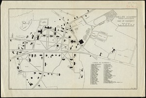
Phillips Academy, Andover, Massachusetts, map of property
54.
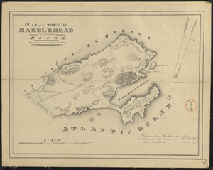
Plan of Marblehead made by John G. Hales, dated 1830
‹ Prev
Next ›
1
2
3