Toggle navigation
LMEC Home
Exhibitions
Georeferencing
Tools for Teachers
Collections
My Favorites
Sign Up / Log In
Search
Search the map portal
Map Collection
Map Collection
Map Sets
Search
Search
Search for
Search In
All Fields
Creator
Title
Subject
Place
Search All Digital Collections
Advanced Search
98 Results
My Search
Start Over
g1105
Remove constraint g1105
Filter your Search
Place
North and Central America
68
United States
27
Canada
14
North America
6
Québec
6
Atlantic Ocean
4
French Guiana
4
New England
4
more
Place
»
Topic
North America--Maps--Early works to 1800
6
America--Discovery and Exploration--Maps--Early works to 1800
5
Québec (Québec)--Maps--Early works to 1800
5
Tactics--Maps--Early works to 1800
5
Braddock's Campaign, 1755--Maps
4
New England--Maps--Early works to 1800
4
United States--History--French and Indian War, 1754-1763--Maps
4
United States--History--French and Indian War, 1754-1763--Maps--Early works to 1800
4
more
Topic
»
Date
Date range begin
–
Date range end
Current results range from
1511
to
1777
View distribution
Creator
Jefferys, Thomas, -1771
76
Sayer, Robert, 1725-1794
66
Celi, Francisco Mathias
8
Le Rouge, Georges-Louis.
7
Green, John, -1757
6
Orme, Robert, -1781
6
Bellin, Jacques Nicolas, 1703-1772
2
Bully, le sieur
2
more
Creator
»
Format
Maps/Atlases
98
Georeferenced
Yes
1
No
97
Collection
Norman B. Leventhal Map Center Collection
98
American Revolutionary War-Era Maps
68
Maritime Charts and Atlases
20
Boston and New England Maps
4
Urban Maps
2
Available to use
No known restrictions
98
Search Constraints
Sort by date (desc)
relevance
title
date (asc)
date (desc)
Number of results to display per page
20 per page
10
per page
20
per page
50
per page
100
per page
View results as:
grid view
map view
Search Results
41.
North view of Pensacola, on the island of Santa Rosa ; Plan of the harbour and settlement of Pensacola
42.
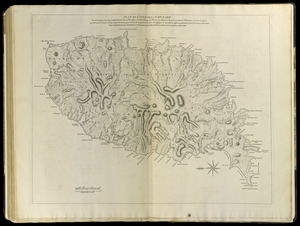
Païs cedés, sheet IId, containing the Peninsula & Gulf of Florida, with the Bahama Islands
43.
Païs cedés, sheet Ist, containing the coast of Louisiana and Florida
44.
Plan de l'isle de la Grenade : ou sont marqués dans leur juste position, les ports et mouillages, les ville et bourgs, les...
45.
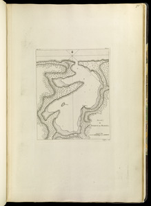
Plan de Puerto de Mariel
46.
Plan of Bahía Honda ; Plan of Puerto de Cavañas
47.
Plan of Bahia Xagua on the south side of Cuba ; Plan of the Colorado Rocks, near the west end of Cuba
48.
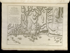
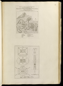
Plan of Fort le Quesne, built by the French at the fork of the Ohio and Monongahela in 1754
49.
Plan of Guantanimo, called by the English Cumberland Harbor ; Plan of the city and harbour of St. Jago de Cuba
50.
Plan of La Vera Cruz, from Spanish draughts ; Plan of Port Royal Laguna, commonly called Logwood Creeks
51.
Plan of Puerto Cavello, on the coast of the Caracas ; Plan of Puerto de La Guaira on the coast of the Caracas
52.
A plan of Quebec the capital of New France or Canada
53.
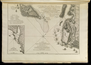
Plan of the attack against Basseterre on the island of Guadeloupe by a squadron of his Majesty's ships of war commanded by...
54.
Plan of the attack against Fort Louis now Fort George, at Point à Pitre on the island of Guadaloupe : by a squadron of His...
55.
Plan of the battle near Bushy Run, gained by Colonel Bouquet over the Delawares, Shawanese, Mingoes, Wyandots, Mohikons,...
56.
A plan of the city, and fortifications, of Louisburg : from a survey made by Richard Gridley, Lieut. Coll. of the Train of...
57.
Plan of the city and harbour of the Havana ; Plan of Bahia de Matanzas
58.
Plan of the city and suburbs of Carthagena ; Plan of the bay & town of Sta. Martha, on the coast of Tierra Firma
59.
Plan of the city of San Domingo
60.
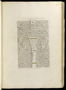
A plan of the disposition of the advanced party consisting of 400 men : to defend the workers in making the road
‹ Prev
Next ›
1
2
3
4
5