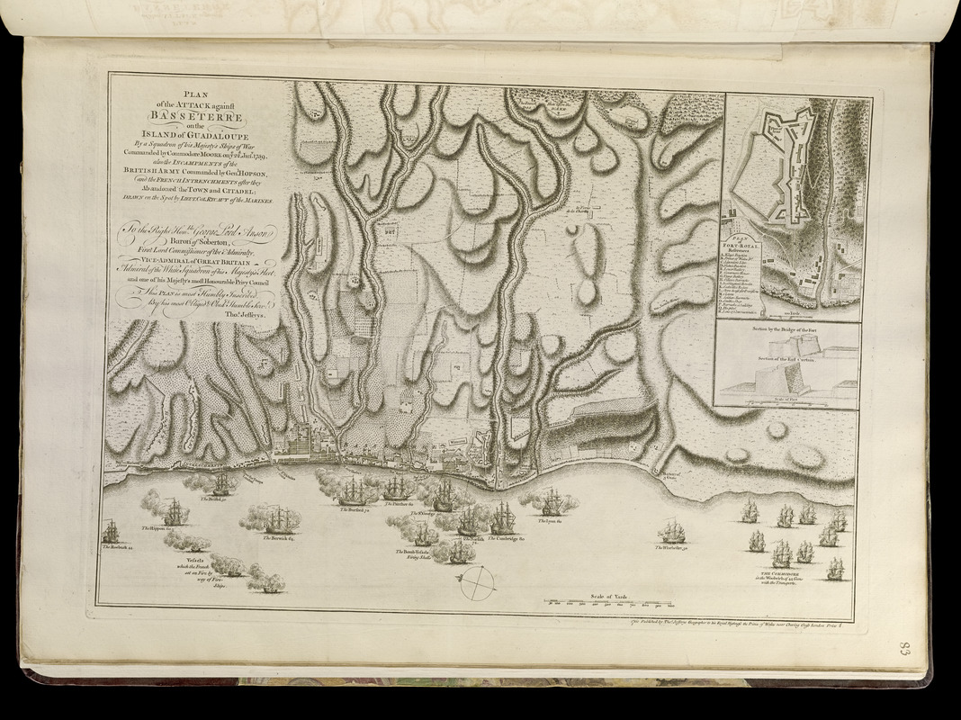
Plan of the attack against Basseterre on the island of Guadeloupe by a squadron of his Majesty's ships of war commanded by Commodore Moore on ye 22d Jan. 1759 : also the incampments of the British army commanded by Genl. Hopson, and the French intrenchments after they abandoned the town and citadel
This map is also available in American Revolutionary Geographies Online (ARGO), a collections portal especially built for material relating to the American Revolutionary War Era. Visit ARGO to learn more about this item and explore the historical geography of North America in the late eighteenth century.
Item Information
- Title:
- Plan of the attack against Basseterre on the island of Guadeloupe by a squadron of his Majesty's ships of war commanded by Commodore Moore on ye 22d Jan. 1759 : also the incampments of the British army commanded by Genl. Hopson, and the French intrenchments after they abandoned the town and citadel
- Creator:
- Rycaut, Edward, fl. 1756-1763
- Contributor:
- Jefferys, Thomas, -1771
- Contributor:
- Sayer, Robert, 1725-1794
- Name on Item:
-
drawn on the sopot by Lieut. Col. Rycaut of the Marines
- Date:
-
[1768]
- Format:
-
Maps/Atlases
- Location:
-
Boston Public Library
Norman B. Leventhal Map & Education Center - Collection (local):
-
Norman B. Leventhal Map & Education Center Collection
- Subjects:
-
Seven Years' War, 1756-1763--Maps--Early works to 1800
West Indies--History--1756-1763--Maps--Early works to 1800
Basse-Terre (Guadeloupe)--Maps--Early works to 1800
- Places:
-
Guadeloupe (territory)Basse Terre (island)Basse Terre
- Extent:
- 1 map ; 32 x 47 cm.
- Terms of Use:
-
No known copyright restrictions.
No known restrictions on use.
- Publisher:
-
London :
Thos. Jefferys
- Scale:
-
Scale [ca. 1:11,700]
- Language:
-
English
- Notes:
-
Shows fortifications, entrenchments, troops, and ships.
Oriented with north towards the upper left.
Relief shown by hachures.
Inset: Plan of Fort-Royal.
Includes ill. of 2 cross-sections: Section by the bridge of the fort -- Section of the east curtain.
Includes dedication to Lord George Anson.
Appears in Jefferys' General topography of North America and the West Indies. London: Printed for Robert Sayer, ... and Thomas Jefferys, 1768.
- Notes (date):
-
This date is inferred.
- Notes (citation):
-
Phillips. List of maps of America, p. 136
Phillips, 1196
- Identifier:
-
4000137_0109r
- Call #:
-
G1105 .J4 1768
- Barcode:
-
30000003256623