Toggle navigation
LMEC Home
Exhibitions
Georeferencing
Tools for Teachers
Collections
My Favorites
Sign Up / Log In
Search
Search the map portal
Map Collection
Map Collection
Map Sets
Search
Search
Search for
Search In
All Fields
Creator
Title
Subject
Place
Search All Digital Collections
Advanced Search
585 Results
My Search
Start Over
East Boston
Remove constraint East Boston
Filter your Search
Place
North and Central America
409
United States
334
Massachusetts
151
Suffolk (county)
129
Boston
125
Asia
63
Europe
47
Canada
42
more
Place
»
Topic
Boston (Mass.)--Maps
71
East Boston (Boston, Mass.)--Maps
36
United States--Maps
16
Real property--Massachusetts--Boston--Maps
15
Middle East--Maps
14
City planning--Massachusetts--Boston--Maps
12
Coasts--Newfoundland and Labrador--Maps
11
Urban renewal--Massachusetts--Boston--Maps
11
more
Topic
»
Date
Date range begin
–
Date range end
Current results range from
1482
to
2023
View distribution
Creator
United States. Hydrographic Office
55
Boston Redevelopment Authority
14
Des Barres, Joseph F. W. (Joseph Frederick Wallet), 1722-1824
12
Ptolemy, 2nd cent
11
Boston (Mass.). Engineering Dept
10
Boynton, George W., d. 1884
10
Moll, Herman, d. 1732
10
O.H. Bailey & Co
10
more
Creator
»
Format
Maps/Atlases
579
Manuscripts
13
Drawings/Illustrations
3
Prints
3
Books
1
Georeferenced
Yes
74
No
511
Collection
Norman B. Leventhal Map & Education Center Collection
540
Boston and New England Maps
172
Urban Maps
163
Maritime Charts and Atlases
103
American Revolutionary War-Era Maps
65
Mapping Boston Collection
20
Boston Redevelopment Authority Collection
18
American Textile History Museum Image Collection
6
more
Collection
»
Available to use
No known restrictions
543
Creative Commons license
29
Search Constraints
Sort by relevance
relevance
title
date (asc)
date (desc)
Number of results to display per page
20 per page
10
per page
20
per page
50
per page
100
per page
View results as:
grid view
map view
Search Results
521.
The Graphic parliamentary map showing members returned for county divisions and boroughs : their political party, and the...
522.
Map of the city & county of New York
523.
A new and exact map of the dominions of the King of Great Britain on ye continent of North America : containing Newfoundland,...
524.
Paskaart van Brasil van Rio de los Amazones tot Rio de la Plata
525.
Aboriginal map of North America, denoting the boundaries and the locations of various Indian tribes
526.
Essexiae descriptio = The description of Essex
527.
Huntingdonensis comitatus Huntington Shire
528.
Map of the City of Brooklyn as consolidated by an act of the legislature of the State of New York : including Brooklyn,...
529.
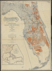
A new sectional map of Florida
530.
Surria : vernacule Surrey
531.
Tabula XI Asiae
532.
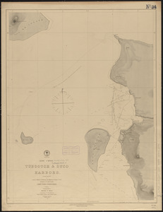
(Loo Choo) Tubootch & Suco Harbors
533.
Comitatus Nottinghamiensis : sive Nottingham Shire
534.
Map of the vicinity of Yorktown, Virginia, 1881
535.
New Engelland, New York, New Yersey und Pensilvania
536.
North America
537.
Suthsexia : vernacule Sussex
538.
Texas New Yorker travelers' railroad map of the State of Texas
539.
United States of America : The course of the River St. Laurence, from Lake Ontario, to Manicougan Point
540.
Carta particolare della Brasilia, che comincia con il capo S. Antonio et finisce con il porto del' Spirito Sancto
‹ Prev
Next ›
1
2
…
23
24
25
26
27
28
29
30