Toggle navigation
LMEC Home
Exhibitions
Georeferencing
Tools for Teachers
Collections
My Favorites
Sign Up / Log In
Search
Search the map portal
Map Collection
Map Collection
Map Sets
Search
Search
Search for
Search In
All Fields
Creator
Title
Subject
Place
Search All Digital Collections
Advanced Search
2261 Results
My Search
Start Over
london
Remove constraint london
Filter your Search
Place
North and Central America
1,492
United States
943
Europe
363
Canada
347
North America
194
New York
129
Massachusetts
117
New England
104
more
Place
»
Topic
North America--Maps--Early works to 1800
137
Coasts--Nova Scotia--Maps
64
New England--Maps--Early works to 1800
57
United States--History--French and Indian War, 1754-1763--Maps
57
United States--History--French and Indian War, 1754-1763--Maps, Manuscript--Early works to 1800
56
United States--Maps--Early works to 1800
54
United States--History--Revolution, 1775-1783--Maps
40
Nova Scotia--Maps--Early works to 1800
39
more
Topic
»
Date
Date range begin
–
Date range end
Current results range from
1624
to
1999
View distribution
Creator
Des Barres, Joseph F. W. (Joseph Frederick Wallet), 1722-1824
242
Jefferys, Thomas, -1771
167
George, III, King of Great Britain, 1738-1820
149
George, IV, King of Great Britain, 1762-1830
148
Sayer, Robert, 1725-1794
115
Faden, William, 1749-1836
109
Moll, Herman, d. 1732
72
Robert Sayer and John Bennett (Firm)
57
more
Creator
»
Format
Maps/Atlases
2,219
Manuscripts
161
Prints
23
Drawings/Illustrations
15
Books
4
Objects/Artifacts
1
Georeferenced
Yes
137
No
2,124
Collection
American Revolutionary War-Era Maps
1,355
Norman B. Leventhal Map & Education Center Collection
1,305
Maritime Charts and Atlases
263
British Library Collection
163
William L. Clements Library Collection
160
Boston and New England Maps
152
Richard H. Brown Revolutionary War Map Collection at Mount Vernon
146
MacLean Collection Map Library
140
more
Collection
»
Available to use
No known restrictions
1,271
Creative Commons license
569
Search Constraints
Sort by relevance
relevance
title
date (asc)
date (desc)
Number of results to display per page
20 per page
10
per page
20
per page
50
per page
100
per page
View results as:
grid view
map view
Search Results
501.
Carte tres curieuse de la Mer du Sud, contenant des remarques nouvelles et tres utiles non seulement sur les ports et iles de...
502.
BOWLES'S NEW POCKET MAP OF THE UNITED STATES OF AMERICA : WITH THE BRITISH POSSESSIONS OF CANADA, NOVA SCOTIA, AND OF...
503.
The harbour of Casco Bay and islands adjacent
504.
The harbour of Casco Bay and islands adjacent
505.
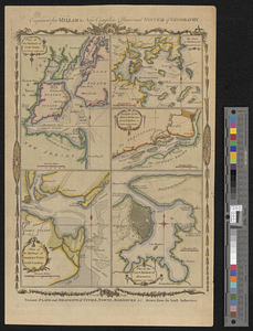
[Chart of Nantucket Island and the eastern half of Martha's Vineyard]
506.
Draught of the river Delaware from Chester to Philadelphia
507.
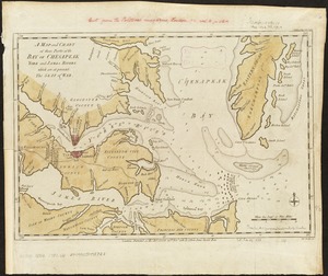
A map and chart of those parts of the Bay of Chesapeak, York and James Rivers which are at present the seat of war
508.
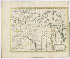
A map of Carolana and of the river Meschacebe &c
509.
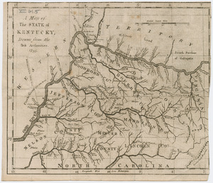
A map of the state of Kentucky
510.
A new chart of the Bahama Islands and the Windward Passage
511.
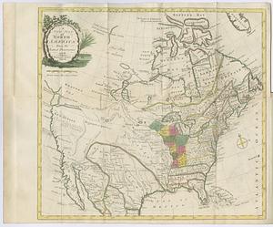
A new map of North America
512.
A new map of North America : from the latest discoveries
513.
A plan of Captain Carvers travels in the interior parts of North America in 1776 and 1767
514.
Plan of the city & harbour of Havanna, capital of Cuba
515.
Plan of the harbour of Charles Town, South Carolina
516.
Plan of the harbour of New-York and parts adjacent
517.
The town & harbour of Boston &c.
518.
The United States of North America, with the British & Spanish territories according to the treaty
519.
The west part of Barbary containing Fez, Marocco, Algiers and Tunis / : The east part of Barbary containing Tripoli, Barca and...
520.
Maryland
‹ Prev
Next ›
1
2
…
22
23
24
25
26
27
28
29
30
…
113
114


![[Chart of Nantucket Island and the eastern half of Martha's Vineyard]](https://bpldcassets.blob.core.windows.net/derivatives/images/commonwealth:7h149z54k/image_thumbnail_300.jpg)