Toggle navigation
LMEC Home
Exhibitions
Georeferencing
Tools for Teachers
Collections
My Favorites
Sign Up / Log In
Search
Search the map portal
Map Collection
Map Collection
Map Sets
Search
Search
Search for
Search In
All Fields
Creator
Title
Subject
Place
Search All Digital Collections
Advanced Search
460 Results
My Search
Start Over
Date
1700
to
1749
Remove constraint Date: <span class='from'>1700</span> to <span class='to'>1749</span>
Filter your Search
Place
North and Central America
272
United States
116
Europe
69
Canada
64
North America
53
South America
48
Africa
39
France
22
more
Place
»
Topic
North America--Maps--Early works to 1800
29
Manuscript maps--Early works to 1800
24
America--Maps--Early works to 1800
19
Western Hemisphere--Maps--Early works to 1800
19
South America--Maps--Early works to 1800
16
Louisbourg (N.S.)--Maps, Manuscript--Early works to 1800
14
Louisbourg (N.S.)--History--Siege, 1745--Maps, Manuscript--Early works to 1800
13
West Indies--Maps--Early works to 1800
12
more
Topic
»
Date
1700
to
1749
[remove]
460
Date range begin
–
Date range end
Current results range from
1668
to
1800
1700
to
1704
53
1705
to
1709
50
1710
to
1714
57
1715
to
1719
50
1720
to
1724
59
1725
to
1729
44
1730
to
1734
75
1735
to
1739
90
1740
to
1744
77
1745
to
1749
125
Creator
Moll, Herman, d. 1732
60
George, III, King of Great Britain, 1738-1820
40
George, IV, King of Great Britain, 1762-1830
39
L'Isle, Guillaume de, 1675-1726
25
Bellin, Jacques Nicolas, 1703-1772
17
Royal United Services Institute for Defence and Security Studies
17
Bastide, John Henry, approximately 1700-1770
15
Bowles, John, 1701-1779
14
more
Creator
»
Format
Maps/Atlases
451
Manuscripts
70
Drawings/Illustrations
5
Prints
3
Georeferenced
Yes
25
No
435
Collection
Norman B. Leventhal Map & Education Center Collection
300
American Revolutionary War-Era Maps
129
British Library Collection
73
Maritime Charts and Atlases
46
Boston and New England Maps
33
William L. Clements Library Collection
28
Newberry Library Collection
22
Urban Maps
17
more
Collection
»
Available to use
No known restrictions
296
Creative Commons license
102
Search Constraints
Sort by relevance
relevance
title
date (asc)
date (desc)
Number of results to display per page
20 per page
10
per page
20
per page
50
per page
100
per page
View results as:
grid view
map view
Search Results
441.
Terra Firma and the Caribbé Islands &c
442.
This discription and [?] of the South Line of the Massachusetts Province which divides between the said Province and the Colony...
443.
This map of North America, according to ye newest and most exact observations is most humbly dedicated by your Lordship's most...
444.
This map of South America, according to the newest and most exact observations
445.
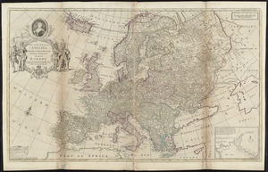
To Her most Sacred Majesty Carolina Queen of Great Britain, France & Ireland, this map of Europe, according to the newest and...
446.
To His Most Serene and August Majesty Peter Alexovitz absolute lord of Russia &c. this map of Moscovy, Poland, Little Tartary,...
447.
To the Right Honourable, Charles Earl of Sunderland, and Baron Spencer of Wormleighton, one of Her Majesty's principal...
448.
To the Right Honourable John Lord Sommers, Baron of Evesham in ye county of Worcester, president of Her Majesty's most...
449.
To the Right Honourable William, Lord Cowper, Lord High Chancellor of Great Britain, this map of Asia : according to ye newest...
450.
Totius Americae descriptio nova
451.
Totius Americae septentrionalis et meridionalis novissima repræsentatio quam ex singulis recantium geographorum tabulis...
452.
The town of Boston in New England
453.
A tract of land granted to George Murray and Jacobas Bruyn lying & being in the county of Ulster on the west side of the Wall...
454.
Triangles on Mercator projection between St. Augustine and Cape Breton and St. Augustine and Cape Ortegal
455.
A view of the castle of Belem and the city of Lisbon as it appears from thence ; A map of the mouth of the famous river Tagus...
456.
Virginia and Maryland
457.
Virginia, Maryland, Pennsilvania, east & west New Jarsey
458.
Virginia Marylandia et Carolina in America septentrionali Brittannorum industria excultæ
459.
The west part of Barbary containing Fez, Marocco, Algiers and Tunis / : The east part of Barbary containing Tripoli, Barca and...
460.
Xingye dingxiang fang yangzhitu
‹ Prev
Next ›
1
2
…
19
20
21
22
23

![This discription and [?] of the South Line of the Massachusetts Province which divides between the said Province and the Colony of Connecticut was made and Taken the Twenty Sixth day of October 1713 In Presence of Col. Samuel Partridge, Col. John Pynchon and [?] William Dudley Commissioners for the Massachusetts, and William Pithkin and William Whiting Esqrs for Connecticut wherein is discribed and Set down the Sain Line from Woodward and Saffery Station [?] to Connecticut River with the Several Towns farms and grants adjacent and Lying near the Same](https://bpldcassets.blob.core.windows.net/derivatives/images/commonwealth:hx11z566k/image_thumbnail_300.jpg)