Toggle navigation
LMEC Home
Exhibitions
Georeferencing
Tools for Teachers
Collections
My Favorites
Sign Up / Log In
Search
Search the map portal
Map Collection
Map Collection
Map Sets
Search
Search
Search for
Search In
All Fields
Creator
Title
Subject
Place
Search All Digital Collections
Advanced Search
41 Results
My Search
Start Over
Date
1944
Remove constraint Date: <span class='single'>1944</span>
Filter your Search
Place
North and Central America
24
United States
23
Massachusetts
8
World
6
Boston
5
New England
5
Suffolk (county)
5
Asia
4
more
Place
»
Topic
United States--Maps
5
World maps
4
Fire risk assessment
3
Insurance surveys
3
New England--Maps--Early works to 1800--Facsimiles
3
Boston (Mass.)--Maps
2
Factories
2
Germany--Maps
2
more
Topic
»
Date
1944
[remove]
41
Date range begin
–
Date range end
Current results range from
1770
to
1999
1944
to
1944
41
Creator
United States. Office of Strategic Services. Research and Analysis Branch
7
Associated Factory Mutual Fire Insurance Companies
3
Chase, Ernest Dudley, 1878-1966
3
Chase, Ernest Dudley, 1878-
2
United States. Office of Strategic Services. Reproduction Branch
2
Whiting, Oliver K.
2
Artzybasheff, Boris, 1899-1965
1
Boston (Mass.). Department of Parks. Board of Commissioners
1
more
Creator
»
Format
Maps/Atlases
40
Photographs
1
Georeferenced
Yes
2
No
39
Collection
Norman B. Leventhal Map & Education Center Collection
35
Boston and New England Maps
4
American Textile History Museum Image Collection
3
Urban Maps
3
David Judkins Weaver Papers
2
American Revolutionary War-Era Maps
1
Lucius Beebe Memorial Library Historic Maps
1
Ralph Finos Map Collection at Phillips Academy
1
more
Collection
»
Available to use
No known restrictions
36
Search Constraints
Sort by relevance
relevance
title
date (asc)
date (desc)
Number of results to display per page
20 per page
10
per page
20
per page
50
per page
100
per page
View results as:
grid view
map view
Search Results
21.
Map of the Back Bay Fens showing the public ways bordering and crossing them and the neighboring newly laid out parts of...
22.
A mapp of New England
23.
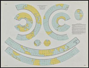
Mercator map of the world united : a pictorial history of transport and communications and paths to permanent peace
24.
Netherlands New Guinea : approximation of population distribution
25.
Northern Philippines land utilization
26.
Outline maps for the construction of a model of the world, based on the Lambert conformal conic projection
27.
Peace map of the world united : a pictorial history of transportation and communications from Jonah to the jet plane as paths...
28.
A pictorial map of the United States
29.
Plan of corner of Centry & Beacon St's -- 1741
30.
Plan of the burnt district : showing proposed improvements in streets. Nov. 12th 1872
31.
Los recursos de los Estados Unidos
32.
A small map of the sea coast of New England together with the outlines of several of the provinces lying thereon, 1738
33.
The south part of New-England, as it is planted this yeare, 1635
34.
The story map of flying : being a chronicle of man's conquest of the air
35.
To his excellency William Shirley Esqr., Captain General and Commander in Chief, in and over his Majesty's province of the...
36.
Town of Brookline, Mass. assessors' plans 1944
37.
The town of Winchester, Massachusetts
38.
United Shoe Machinery Corporation "O. A. Miller Treeing Machine Branch," Plymouth, N.H. [insurance map]
39.
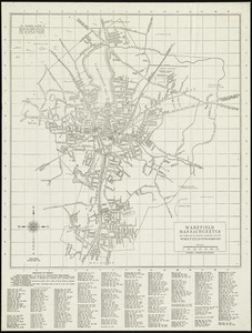
Wakefield, Massachusetts
40.
White Mountain National Forest : New Hampshire-Maine
‹ Prev
Next ›
1
2
3


![United Shoe Machinery Corporation "O. A. Miller Treeing Machine Branch," Plymouth, N.H. [insurance map]](https://bpldcassets.blob.core.windows.net/derivatives/images/commonwealth:ww72c0288/image_thumbnail_300.jpg)