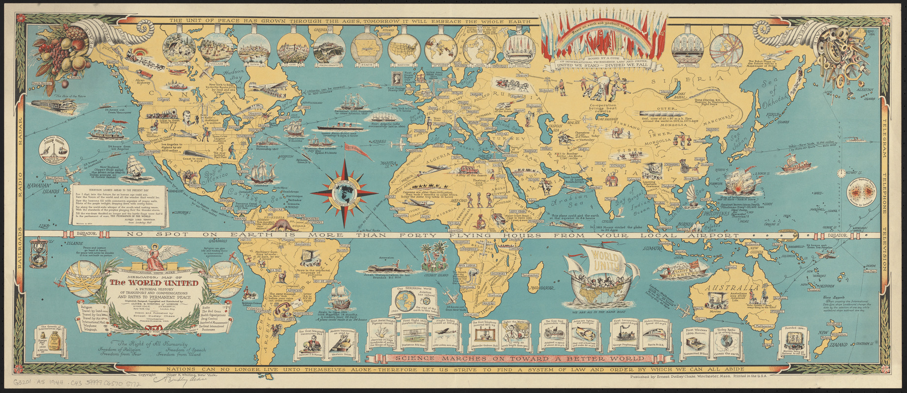
Mercator map of the world united : a pictorial history of transport and communications and paths to permanent peace
Item Information
- Title:
- Mercator map of the world united : a pictorial history of transport and communications and paths to permanent peace
- Title (alt.):
-
Map of the world united
- Creator:
- Chase, Ernest Dudley, 1878-
- Artist:
- Chase, Ernest Dudley, 1878-
- Cartographer:
- Chase, Ernest Dudley, 1878-
- Publisher:
- Chase, Ernest Dudley, 1878-
- Copyright holder:
- Whiting, Oliver K.
- Name on Item:
-
originated, designed, copyrighted and distributed by Oliver K. Whiting of London ; drawn and published by Ernest Dudley Chase
- Date:
-
[1944]
- Format:
-
Maps/Atlases
- Location:
-
Boston Public Library
Norman B. Leventhal Map & Education Center - Collection (local):
-
Norman B. Leventhal Map & Education Center Collection
- Subjects:
-
World maps
Transportation--Maps
Pictorial maps
- Places:
-
World
- Extent:
- 1 map : color ; 37 x 87 cm, on sheet 40 x 92 cm
- Terms of Use:
-
No known copyright restrictions.
No known restrictions on use.
- Publisher:
-
Winchester, Massachusetts :
Ernest Dudley Chase
- Scale:
-
Scale not given
- Projection:
- Mercator projection
- Language:
-
English
- Notes:
-
Copyright Oliver K. Whiting, New York.
"Railroads, radio, radar" in left border; "telegram, telephone, television" in right border; "The unit of peace has grown through the ages, tomorrow it will embrace the whole earth" in top border; "Nations can no longer live unto themselves alone - therefore let us strive to find a system of law and order by which we can all abide" in bottom border.
Includes decorative border, color illustrations, historical notes, quote from Lord Alfred Tennyson dated 1854, comparative "advancements" vignettes and more.
- Notes (date):
-
This date is inferred.
- Identifier:
-
06_01_014715
- Call #:
-
G3201.A5 1944 .C43
- Barcode:
-
39999065705772


