Toggle navigation
LMEC Home
Exhibitions
Georeferencing
Tools for Teachers
Collections
My Favorites
Sign Up / Log In
Search
Search the map portal
Map Collection
Map Collection
Map Sets
Search
Search
Search for
Search In
All Fields
Creator
Title
Subject
Place
Search All Digital Collections
Advanced Search
1085 Results
My Search
Start Over
Back Bay Boston
Remove constraint Back Bay Boston
Filter your Search
Place
North and Central America
834
United States
532
Massachusetts
238
Suffolk (county)
179
Boston
173
Canada
116
South America
62
Asia
61
more
Place
»
Topic
Boston (Mass.)--Maps
60
City planning--Massachusetts--Boston--Maps
48
Back Bay (Boston, Mass.)--Maps
47
North America--Maps--Early works to 1800
35
Landowners--Massachusetts--Boston--Maps
26
Real property--Massachusetts--Boston--Maps
26
New England--Maps--Early works to 1800
24
Nova Scotia--Maps--Early works to 1800
24
more
Topic
»
Date
Date range begin
–
Date range end
Current results range from
1565
to
2020
View distribution
Creator
United States. Hydrographic Office
277
Des Barres, Joseph F. W. (Joseph Frederick Wallet), 1722-1824
64
Boston Redevelopment Authority
36
Jefferys, Thomas, -1771
24
Sayer, Robert, 1725-1794
24
Franke, M. (Max)
23
U.S. Lake Survey
22
United States Exploring Expedition (1838-1842)
21
more
Creator
»
Format
Maps/Atlases
1,070
Manuscripts
69
Drawings/Illustrations
10
Objects/Artifacts
3
Prints
3
Books
1
Posters
1
Georeferenced
Yes
54
No
1,031
Collection
Norman B. Leventhal Map & Education Center Collection
946
Maritime Charts and Atlases
481
Boston and New England Maps
266
American Revolutionary War-Era Maps
231
Urban Maps
138
Boston Redevelopment Authority Collection
54
Mapping Boston Collection
40
Library of Congress Collection
35
more
Collection
»
Available to use
No known restrictions
947
Creative Commons license
112
Search Constraints
Sort by relevance
relevance
title
date (asc)
date (desc)
Number of results to display per page
20 per page
10
per page
20
per page
50
per page
100
per page
View results as:
grid view
map view
Search Results
341.
[A map of the east coast of America from Newfoundland to the Bay of Honduras]
342.
Boston Harbor
343.
Boston : 1899
344.
Eldridge's chart no. 10 : Buzzard's Bay
345.
Plan of the roads between Boston and Albany : survey'd by order of the governor in pursuance of a resolution of the General...
346.
Plan of Neponset River and part of Dorchester Bay showing the harbor lines proposed by the Commissioners 1854
347.
Map of the Back Bay Fens showing the public ways bordering and crossing them and the neighboring newly laid out parts of...
348.
North America, south coast of Newfoundland : Devil Bay to Knife Bay : from a British survey in 1872 & 1873 ; republication of...
349.
Boston Harbor, Massachusetts
350.
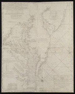
A new and accurate chart of the Bay of Chesapeak including Delaware Bay with all the shoals, channels, islands, entrances,...
351.
A new and accurate chart of the Bay of Chesapeak including Delaware Bay with all the shoals, channels, islands, entrances,...
352.
A new and accurate chart of the Bay of Chesapeak including Delaware Bay with all the shoals, channels, islands, entrances,...
353.
Plan of cottage lots on Littlejohn's Island, Casco Bay, about 7 1/2 miles northeast of Portland
354.
Boston
355.
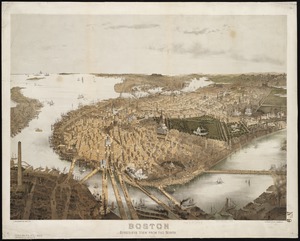
Boston : bird's-eye view from the north
356.
Boston & harbour
357.
Newfoundland, east coast, Broyle Hr. to Renewse Hr. including Caplin Bay, Ferryland Hr., Aquafort Hr. & Fermeuse Hr.
358.
Harbours of Papieti, Toanoa, Papaoa and Matavai Bay, with the ship channel through reef, island of Tahiti
359.
Boston Harbor, Massachusetts
360.
A chart of the N.E. coast of Cape Breton Island, from St. Ann Bay to Cape Morien
‹ Prev
Next ›
1
2
…
14
15
16
17
18
19
20
21
22
…
54
55
![[A map of the east coast of America from Newfoundland to the Bay of Honduras]](https://bpldcassets.blob.core.windows.net/derivatives/images/commonwealth:hx11z584h/image_thumbnail_300.jpg)