Toggle navigation
LMEC Home
Exhibitions
Georeferencing
Tools for Teachers
Collections
My Favorites
Sign Up / Log In
Search
Search the map portal
Map Collection
Map Collection
Map Sets
Search
Search
Search for
Search In
All Fields
Creator
Title
Subject
Place
Search All Digital Collections
Advanced Search
13385 Results
My Search
Start Over
Date facet yearly ssim
2000
to
2017
Remove constraint Date facet yearly ssim: <span class='from'>2000</span> to <span class='to'>2017</span>
Filter your Search
Place
North and Central America
10,111
United States
8,249
Massachusetts
2,691
Suffolk (county)
1,664
Boston
1,621
Europe
1,386
Canada
949
New York
640
more
Place
»
Topic
Boston (Mass.)--Maps
741
City planning--Massachusetts--Boston--Maps
418
United States--History--Revolution, 1775-1783--Maps
329
United States--Maps
315
Urban renewal--Massachusetts--Boston--Maps
254
Real property--Massachusetts--Boston--Maps
252
Massachusetts--Maps
219
Insurance surveys
197
more
Topic
»
Date
Date range begin
–
Date range end
Current results range from
1482
to
2023
View distribution
Creator
United States. Hydrographic Office
595
Boston Redevelopment Authority
403
Des Barres, Joseph F. W. (Joseph Frederick Wallet), 1722-1824
247
Royal United Services Institute for Defence and Security Studies
160
Jefferys, Thomas, -1771
154
George, III, King of Great Britain, 1738-1820
152
George, IV, King of Great Britain, 1762-1830
151
O.H. Bailey & Co
148
more
Creator
»
Format
Maps/Atlases
13,205
Manuscripts
985
Prints
102
Books
49
Drawings/Illustrations
44
Photographs
15
Objects/Artifacts
13
Documents
7
more
Format
»
Georeferenced
Yes
979
No
12,406
Collection
Norman B. Leventhal Map & Education Center Collection
8,891
American Revolutionary War-Era Maps
3,305
Boston and New England Maps
2,804
Urban Maps
2,397
Maritime Charts and Atlases
1,150
William L. Clements Library Collection
910
Library of Congress Collection
618
Boston Redevelopment Authority Collection
475
more
Collection
»
Available to use
No known restrictions
9,952
Creative Commons license
1,677
Search Constraints
Sort by relevance
relevance
title
date (asc)
date (desc)
Number of results to display per page
20 per page
10
per page
20
per page
50
per page
100
per page
View results as:
grid view
map view
Search Results
2701.
Cuba, south coast, approaches to Ports Casilda and Masio with the adjacent anchorages : from a Spanish government chart of 1879
2702.
Culiacanae, Americae regionis, descriptio : Hispaniolae, Cubae, aliarumque insularum circumiacientium, delineatio
2703.
Cultural facilities conceptual plan
2704.
Cumbria & Westmoria : vulgo Cumberland & Westmorland
2705.
Cummings' map of Columbia and Montour counties, Penn'a : from actual surveys
2706.
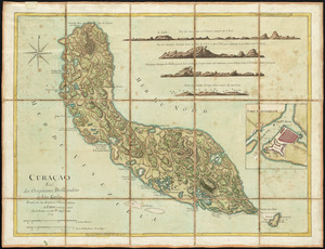
Curaçao : tiré des originaux Hollandois de Van Keulen ; dressé sur les dernieres observations
2707.
Curaçao
2708.
Curious enigmatical epitaphs
2709.
De cust van Barbaria, Gualata, Arguyn en Geneheo van Capo S Vincente tot Capo Verde
2710.
Cyclists' road map of Massachusetts
2711.
Cyclists' road map of the Philadelphia District
2712.
Dagbladets kart over krigsskuepladsen
2713.
Daily Mail map of the battlefields of France
2714.
Daily mail war map
2715.
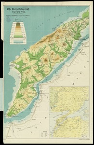
The Daily Telegraph gazetteer war map (no. 4)
2716.
The Daily Telegraph map no. 25 : races of Eastern Europe
2717.
The Daily Telegraph war map no. 10
2718.
The Daily Telegraph war map no. 11
2719.
The Daily Telegraph war map no. 12
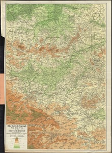
2720.
The Daily Telegraph war map no. 13 of the British front
‹ Prev
Next ›
1
2
…
132
133
134
135
136
137
138
139
140
…
669
670