Culiacanae, Americae regionis, descriptio : Hispaniolae, Cubae, aliarumque insularum circumiacientium, delineatio

Item Information
- Title:
- Culiacanae, Americae regionis, descriptio : Hispaniolae, Cubae, aliarumque insularum circumiacientium, delineatio
- Title (alt.):
-
Hispaniolae, Cubae, aliarumque insularum circumiacientium, delineatio
Culiacanae, Americae regionis, descriptio
- Description:
-
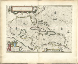
Published in Abraham Ortelius, Theatrum Orbis Terrarum (Antwerp, 1579). One of the landmarks in the history of map making was Abraham Ortelius' Theatrum Orbis Terrarum, which is recognized as the first modern atlas publication. Originally published in 1570 in Antwerp, this collection of similarly designed maps bound in a book format, contained 53 contemporary maps: one world map, one of each of the four recognized continents (Europe, Asia, Africa, and the Americas), with the remainder devoted to European countries and regions. Because of the popularity of this novel publication, Ortelius brought out enlarged and geographically expanded editions almost every year until the first decade of the 17th century. In 1579, he added a number of maps depicting in detail portions of the newly explored and settled regions in the Americas, including this sheet with two separate maps. One focuses on the major islands in the Caribbean--Cuba, Hispaniola, and Jamaica--first explored and settled by the Spanish in the 1490s and still under Spanish control by the end of the 16th century. The other map depicts the region around the Spanish settlement of Culiacanae, now the capital city of the state of Sinaloa on the west coast of Mexico.
- Creator:
- Ortelius, Abraham, 1527-1598
- Name on Item:
-
A. Ortelius.
- Date:
-
1579
- Format:
-
Maps/Atlases
- Location:
-
Boston Public Library
Norman B. Leventhal Map & Education Center - Collection (local):
-
Norman B. Leventhal Map & Education Center Collection
- Subjects:
-
Caribbean Area--Maps--Early works to 1800
West Indies--Maps--Early works to 1800
Culiacán (Sinaloa, Mexico)--Maps--Early works to 1800
- Places:
-
MexicoSinaloaCuliacán
West Indies
Caribbean Sea
- Extent:
- 2 maps on 1 sheet : col. ; 21 x 49 cm. and 22 x 49 cm. on sheet 43 x 56 cm.
- Terms of Use:
-
No known copyright restrictions.
No known restrictions on use.
- Publisher:
-
Antwerp :
A. Ortelius
- Scale:
-
Scale not given.
- Language:
-
Latin
- Notes:
-
Appears in Ortelius' Theatrum orbis terrarum. Antwerp. 1579.
Featured in the Faces & Places Exhibit, Kravis Center, Palm Beach, FL, since 2005. MB (BRL)
Cataloging, conservation, and digitization made possible in part by The National Endowment for the Humanities: Exploring the human endeavor.
- Identifier:
-
06_01_010505
- Call #:
-
G4390 1579 .O7
- Barcode:
-
39999052507991