Toggle navigation
LMEC Home
Exhibitions
Georeferencing
Tools for Teachers
Collections
My Favorites
Sign Up / Log In
Search
Search the map portal
Map Collection
Map Collection
Map Sets
Search
Search
Search for
Search In
All Fields
Creator
Title
Subject
Place
Search All Digital Collections
Advanced Search
1003 Results
My Search
Start Over
More Like
commonwealth-oai:mc87tn873
Remove constraint More Like: commonwealth-oai:mc87tn873
Filter your Search
Place
North and Central America
975
United States
715
New York
258
Canada
206
Quebec
112
New Jersey
64
Pennsylvania
62
Massachusetts
54
more
Place
»
Topic
United States--History--Revolution, 1775-1783--Maps
330
United States--History--French and Indian War, 1754-1763--Maps
149
Manhattan (New York, N.Y.)--Maps
51
New York (N.Y.)--Maps
48
Saint Lawrence River--Maps
43
New York (State)--Maps
27
Newport (R.I.)--Maps
27
Hudson River (N.Y. and N.J.)--Maps
22
more
Topic
»
Date
Date range begin
–
Date range end
Current results range from
1700
to
1939
View distribution
Creator
Rocque, Mary Ann
29
Holland, Samuel, 1728-1801
26
Jefferys, Thomas, -1771
25
Montrésor, John, 1736-1799
25
Bellin, Jacques Nicolas, 1703-1772
24
Clinton, Henry, Sir, 1738?-1795
18
Robert Sayer and John Bennett (Firm)
16
Kitchin, Thomas, 1719-1784
14
more
Creator
»
Format
Maps/Atlases
987
Drawings/Illustrations
11
Manuscripts
6
Documents
5
Prints
1
Georeferenced
Yes
14
No
989
Collection
American Revolutionary War-Era Maps
941
William L. Clements Library Collection
909
Norman B. Leventhal Map & Education Center Collection
63
Urban Maps
35
Maps from AAS
11
Boston and New England Maps
6
MacLean Collection Map Library
5
New-York Historical Society Collection
5
more
Collection
»
Available to use
No known restrictions
68
Creative Commons license
7
Search Constraints
Sort by relevance
relevance
title
date (asc)
date (desc)
Number of results to display per page
20 per page
10
per page
20
per page
50
per page
100
per page
View results as:
grid view
map view
Search Results
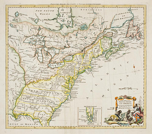
661.
A new map of the British empire in Nth. America, drawn from the latest authorities
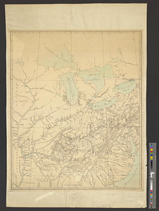
662.
A new map of the Cherokee nation with the names of the towns & rivers : they are situated on no. lat. from 34 to 36
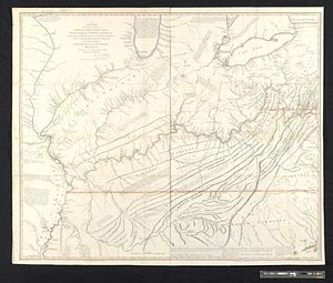
663.
A new map of the western parts of Virginia, Pennsylvania, Maryland and North Carolina; comprehending the river Ohio, and all...
664.
New Port
665.
North America
666.
North America
667.
North America east of the Mississippi, ca. 1790
668.
North America with the West India islands
669.
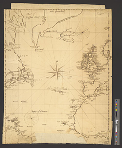
North Atlantic Ocean, ca. 1785
670.
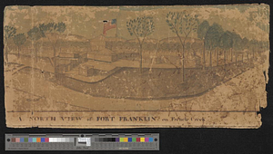
A north view of Fort Franklin on French Creek
671.
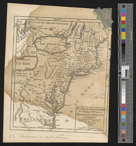
Nouvelle Angleterre, Nlle. York, Nlle. Jeersey, Pensilvanie, Mariland et Virginie
672.
La Nouvelle France ou Canada
673.
Nova orbis sive America Septentrionalis per sua regna provinc. et insul. cura et opera
674.
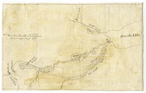
Oneida Lake to the Mohawk River
675.
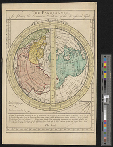
The panorganon for solving the common problems of the terrestrial globe : Northern Hemisphere
676.
Parish of Batiscant. Parish of St. Pierre Becquet. Parish of Champlain. Parish of Gentilly
677.
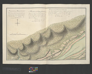
Parish of Beauport. Parish of L'Ange Gardien. Parish of Chateau Richer
678.
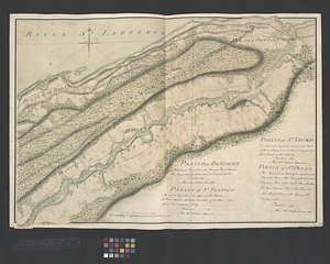
Parish of Berthier. Parish of St. François. Parish of St. Thomas
679.
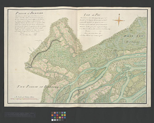
Parish of Bertier. Isle du Pas
680.
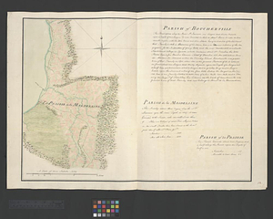
Parish of Boucherville. Parish de la Magdelaine. Parish of La Prairie
‹ Prev
Next ›
1
2
…
30
31
32
33
34
35
36
37
38
…
50
51