Toggle navigation
LMEC Home
Exhibitions
Georeferencing
Tools for Teachers
Collections
My Favorites
Sign Up / Log In
Search
Search the map portal
Map Collection
Map Collection
Map Sets
Search
Search
Search for
Search In
All Fields
Creator
Title
Subject
Place
Search All Digital Collections
Advanced Search
1003 Results
My Search
Start Over
More Like
commonwealth-oai:mc87tn873
Remove constraint More Like: commonwealth-oai:mc87tn873
Filter your Search
Place
North and Central America
975
United States
715
New York
258
Canada
206
Quebec
112
New Jersey
64
Pennsylvania
62
Massachusetts
54
more
Place
»
Topic
United States--History--Revolution, 1775-1783--Maps
330
United States--History--French and Indian War, 1754-1763--Maps
149
Manhattan (New York, N.Y.)--Maps
51
New York (N.Y.)--Maps
48
Saint Lawrence River--Maps
43
New York (State)--Maps
27
Newport (R.I.)--Maps
27
Hudson River (N.Y. and N.J.)--Maps
22
more
Topic
»
Date
Date range begin
–
Date range end
Current results range from
1700
to
1939
View distribution
Creator
Rocque, Mary Ann
29
Holland, Samuel, 1728-1801
26
Jefferys, Thomas, -1771
25
Montrésor, John, 1736-1799
25
Bellin, Jacques Nicolas, 1703-1772
24
Clinton, Henry, Sir, 1738?-1795
18
Robert Sayer and John Bennett (Firm)
16
Kitchin, Thomas, 1719-1784
14
more
Creator
»
Format
Maps/Atlases
987
Drawings/Illustrations
11
Manuscripts
6
Documents
5
Prints
1
Georeferenced
Yes
14
No
989
Collection
American Revolutionary War-Era Maps
941
William L. Clements Library Collection
909
Norman B. Leventhal Map & Education Center Collection
63
Urban Maps
35
Maps from AAS
11
Boston and New England Maps
6
MacLean Collection Map Library
5
New-York Historical Society Collection
5
more
Collection
»
Available to use
No known restrictions
68
Creative Commons license
7
Search Constraints
Sort by relevance
relevance
title
date (asc)
date (desc)
Number of results to display per page
20 per page
10
per page
20
per page
50
per page
100
per page
View results as:
grid view
map view
Search Results
521.
An exact map of Nova Scotia, Newfoundland, gulf and river St. Laurence, and coast of Labrador from the latest observations 1777
522.
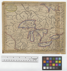
An exact map of the five Great Lakes, with part of Pensilvania, New York, Canada and Hudsons Bay territories from the best surveys
523.
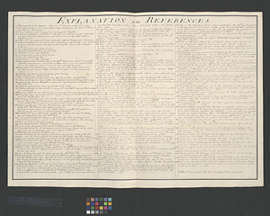
Explanation of the references
524.
Falmouth, Maine
525.
La Floride divisée en Floride et Caroline
526.
Flynt Jenkins sold to Taylor Foster &c plans 1778
527.
Fort Bedford
528.
Fort Edward to Ticonderoga
529.
Fort Halifax and the Kennebec River : Québec July 25th, 1761
530.
Fort Harmar at the Ohio and Muskingum Rivers, ca. 1786
531.
Fort Pitt
532.
Fort William Henry
533.
Four wood lots in no 3
534.
French draught of Lake Champlain & Lake George with remarks of an English prisoner who return'd from Quebec to Fort Edward by...
535.
Gabarus Bay
536.
Gaspee Bay
537.
A general map of North America drawn from the best surveys 1795
538.
A general map of the middle British colonies, in America; viz Virginia, Maryland, Delaware, Pensilvania, New-Jersey, New-York,...
539.
A general plan of the harbours of Port Royal and Kingston Jamaica with the channels leading thereto, and the kays and shoals...
540.
General Wayne's encampment & establishment at Roche de Bout
‹ Prev
Next ›
1
2
…
23
24
25
26
27
28
29
30
31
…
50
51