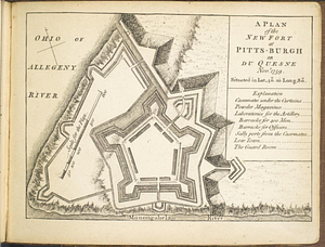
Fort Pitt

This map is also available in American Revolutionary Geographies Online (ARGO), a collections portal especially built for material relating to the American Revolutionary War Era. Visit ARGO to learn more about this item and explore the historical geography of North America in the late eighteenth century.
Item Information
- Title:
- Fort Pitt
- Date:
-
[1764?]
- Format:
-
Maps/Atlases
- Genre:
-
Manuscript maps
- Location:
- William L. Clements Library
- Collection (local):
-
William L. Clements Library Collection
- Subjects:
-
Fort Pitt (Pa.)--Maps
Pittsburgh (Pa.)--Maps
- Places:
-
PennsylvaniaAllegheny (county)Pittsburgh
- Extent:
- 1 ms. map ; 25 x 39 cm
- Terms of Use:
-
The University of Michigan Library provides access to these materials for educational and research purposes. These materials may be under copyright. If you decide to use any of these materials, you are responsible for making your own legal assessment and securing any necessary permission. If you have questions about the collection, please contact the William L. Clements Library.
Contact host institution for more information.
- Scale:
-
Scale indeterminate.
- Language:
-
English
- Catalog Record:
-
Catalog record
- Notes:
-
Pencil sketch map showing outline of fort and indicating positions of one wooden and one brick redoubt.
Dated in Brun as ca. 1760 but presence of a brick redoubt suggests a date of 1764.
- Identifier:
-
5550
- Barcode:
-
B1936620