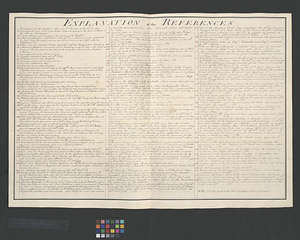
Explanation of the references
This map is also available in American Revolutionary Geographies Online (ARGO), a collections portal especially built for material relating to the American Revolutionary War Era. Visit ARGO to learn more about this item and explore the historical geography of North America in the late eighteenth century.
Item Information
- Title:
- Explanation of the references
- Date:
-
[ca. 1761]
- Format:
-
Documents
- Location:
- William L. Clements Library
- Collection (local):
-
William L. Clements Library Collection
- Subjects:
-
Sainte-Foy, Battle of, Québec, Québec, 1760
Québec Campaign, Québec, 1759
Plains of Abraham, Battle of the, Québec, 1759
United States--History--French and Indian War, 1754-1763
Québec (Québec)--Siege, 1760
- Places:
-
CanadaQuebec (province)Québec
- Extent:
- 1 ms. page ; 51 x 72.7 cm.
- Terms of Use:
-
The University of Michigan Library provides access to these materials for educational and research purposes. These materials may be under copyright. If you decide to use any of these materials, you are responsible for making your own legal assessment and securing any necessary permission. If you have questions about the collection, please contact the William L. Clements Library.
Contact host institution for more information.
- Language:
-
English
- Catalog Record:
-
Catalog record
- Notes:
-
List of references keyed to 3 maps (Sheets 52-54) of the Murray Atlas, identifying major buildings and features of Québec and features relating to the battles of 1759 and 1760.
Corresponding maps are individually cataloged.
Corresponding maps: Plan of Quebec with the positions of the British and French army's on the Heights of Abraham, 13th of Sept. 1759 (Sheet 52) -- Plan of the battle and situation of the British and French armys on the Heights of Abraham the 28th: of April 1760 (Sheet 53) -- Plan of Quebec and the Heights of Abraham, shewing in particular the French encampment after the battle of the 28th (Sheet 54).
Map is sheet 51 of the Murray Atlas of Canada.
- Identifier:
-
725
- Barcode:
-
B8296441


