Toggle navigation
LMEC Home
Exhibitions
Georeferencing
Tools for Teachers
Collections
My Favorites
Sign Up / Log In
Search
Search the map portal
Map Collection
Map Collection
Map Sets
Search
Search
Search for
Search In
All Fields
Creator
Title
Subject
Place
Search All Digital Collections
Advanced Search
938 Results
My Search
Start Over
More Like
commonwealth-oai:k356f1598
Remove constraint More Like: commonwealth-oai:k356f1598
Filter your Search
Place
North and Central America
912
United States
626
Canada
231
New York
193
Quebec
113
Pennsylvania
60
New Jersey
54
Nova Scotia
48
more
Place
»
Topic
United States--History--Revolution, 1775-1783--Maps
305
United States--History--French and Indian War, 1754-1763--Maps
149
Saint Lawrence River--Maps
43
Newport (R.I.)--Maps
27
New York (State)--Maps
25
Hudson River (N.Y. and N.J.)--Maps
21
Québec (Québec)--Maps
21
Louisbourg (N.S.)--Maps
20
more
Topic
»
Date
Date range begin
–
Date range end
Current results range from
1700
to
1921
View distribution
Creator
Rocque, Mary Ann
29
Bellin, Jacques Nicolas, 1703-1772
25
Holland, Samuel, 1728-1801
25
Jefferys, Thomas, -1771
25
Montrésor, John, 1736-1799
25
Clinton, Henry, Sir, 1738?-1795
19
Robert Sayer and John Bennett (Firm)
15
Hills, John, active 1777-1819
13
more
Creator
»
Format
Maps/Atlases
922
Drawings/Illustrations
11
Documents
5
Prints
1
Georeferenced
No
938
Collection
American Revolutionary War-Era Maps
916
William L. Clements Library Collection
909
Norman B. Leventhal Map & Education Center Collection
22
Library and Archives Canada Collection
4
MacLean Collection Map Library
3
Available to use
No known restrictions
22
Search Constraints
Sort by relevance
relevance
title
date (asc)
date (desc)
Number of results to display per page
20 per page
10
per page
20
per page
50
per page
100
per page
View results as:
grid view
map view
Search Results
701.
Plan of the roads between Boston and Albany : survey'd by order of the governor in pursuance of a resolution of the General...
702.
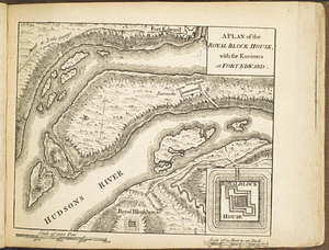
A plan of the Royal Block House, with the environs at Fort Edward
703.
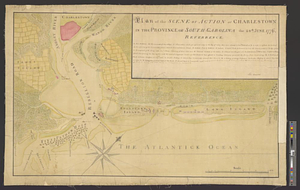
Plan of the scene of action at Charlestown in the province of South Carolina the 28th June 1776
704.
A plan of the sea coast from Gage Point to Cumberland Cape including Dartmouth and Granby Bays with the coal mines in that...
705.
Plan of the seige [sic] of Charlestown in South Carolina
706.
A plan of the settled part of Canada reduced from the large survey made in the years 1760 & 1761 by order of General Murray...
707.
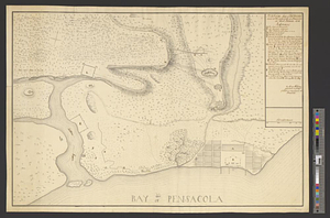
Plan of the siege of Fort George and works adjacent at Pensacola in West Florida, 1781
708.
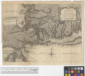
A plan of the Straits of St. Mary and Michilimakinac to shew the situation & importance of the two westernmost settlements of...
709.
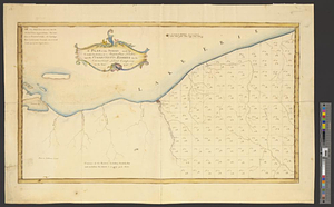
A plan of the survey made by, & under the direction of Augustus Porter upon the Connecticut Reserve for the Connecticut Land...
710.
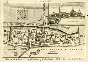
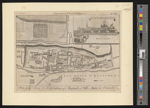
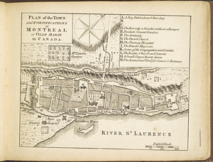
Plan of the town & fortifications of Montreal, or Ville Marie in Canada
711.
Plan of the town & fortifications of Montreal or Ville Marie in Canada
712.
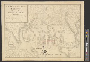
A plan of the town & port of Edenton in Chowan County, North Carolina : survey'd and drawn in 1769
713.
A plan of the town and chart of the harbour of Boston exhibiting a view of the islands castle forts and entrances into the said...
714.
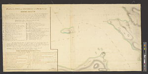
Plan of the town and environs of Newport, Rhode Island : exhibiting its defenses formed before the 8th of August 1778 when the...
715.
Plan of the town and environs of Newport, Rhode Island : exhibiting its defenses formed before the 8th of August 1778 when the...
716.
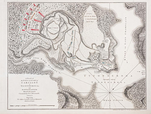
A plan of the town and fort of Carillon at Ticonderoga : with the attack made by the British army commanded by Genl....
717.
Plan of the town and fortifications of Montréal or Ville Marie in Canada
718.
A plan of the town and harbour of Boston and the country adjacent with the road from Boston to Concord shewing the place of the...
719.
Plan of the town of Boston
720.
Plan of the town of Boston with the attack on Bunkers-Hill in the peninsula of Charlestown the 17th of June 1775
‹ Prev
Next ›
1
2
…
32
33
34
35
36
37
38
39
40
…
46
47

![Plan of the seige [sic] of Charlestown in South Carolina](https://bpldcassets.blob.core.windows.net/derivatives/metadata/commonwealth-oai:rb692949z/image_thumbnail_300.jpg)