Toggle navigation
LMEC Home
Exhibitions
Georeferencing
Tools for Teachers
Collections
My Favorites
Sign Up / Log In
Search
Search the map portal
Map Collection
Map Collection
Map Sets
Search
Search
Search for
Search In
All Fields
Creator
Title
Subject
Place
Search All Digital Collections
Advanced Search
1254 Results
My Search
Start Over
More Like
commonwealth-oai:g158gg63r
Remove constraint More Like: commonwealth-oai:g158gg63r
Filter your Search
Place
North and Central America
1,224
United States
942
Canada
251
New York
196
Quebec
112
Pennsylvania
61
New Jersey
54
Nova Scotia
49
more
Place
»
Topic
United States--Maps
330
United States--History--Revolution, 1775-1783--Maps
305
United States--History--French and Indian War, 1754-1763--Maps
152
Canada--Maps
55
Saint Lawrence River--Maps
44
Elections--United States--Maps
36
Railroads--United States--Maps
34
New York (State)--Maps
27
more
Topic
»
Date
Date range begin
–
Date range end
Current results range from
1700
to
2023
View distribution
Creator
Paullin, Charles Oscar, 1868 or 1869-1944
70
Wright, John Kirtland, 1891-1969
70
Rocque, Mary Ann
29
Bellin, Jacques Nicolas, 1703-1772
26
Holland, Samuel, 1728-1801
25
Montrésor, John, 1736-1799
25
Jefferys, Thomas, -1771
24
Clinton, Henry, Sir, 1738?-1795
19
more
Creator
»
Format
Maps/Atlases
1,236
Drawings/Illustrations
11
Documents
5
Prints
3
Books
1
Manuscripts
1
Objects/Artifacts
1
Posters
1
Georeferenced
Yes
67
No
1,187
Collection
American Revolutionary War-Era Maps
942
William L. Clements Library Collection
909
Norman B. Leventhal Map & Education Center Collection
312
Maps from AAS
23
MacLean Collection Map Library
9
Boston and New England Maps
2
David Judkins Weaver Papers
2
Mapping Boston Collection
2
more
Collection
»
Available to use
No known restrictions
237
Creative Commons license
5
Search Constraints
Sort by relevance
relevance
title
date (asc)
date (desc)
Number of results to display per page
20 per page
10
per page
20
per page
50
per page
100
per page
View results as:
grid view
map view
Search Results
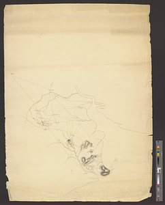
1121.
Scetch [sic] of the blockhouse at the east of Oneda Lake
1122.
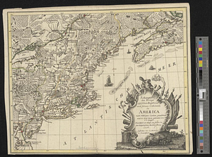
Schauplatz des kriegs zwischen Engelland und seinen collonien in America nach richtigen carten gezeichnet und in diese form...
1123.
The seat of action between the British and American forces or an authentic plan of Staten Island with the neighbouring...
1124.
The seat of action, between the British and American forces or an authentic plan of the western part of Long Island, with the...
1125.
Seat of war in the environs of Philadelphia
1126.
Seconnet Passage
1127.
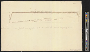
Section of the level of the country
1128.
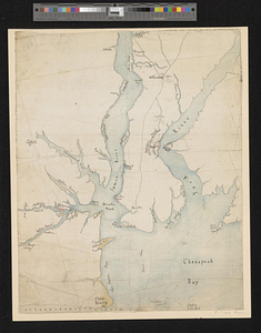
The Seven Islands and the Bay
1129.
The Shoals of Beauport; The River St. Lawrence from the Basin of Quebec to the Falls of Richeu
1130.
Siège d'York 1781 : carte des environs d'York en Virginie avec les attaques et la position des armées Françoise et Américaine...
1131.
Siege of Charleston, South Carolina 1780
1132.
Siege of Charlestown 1780
1133.
Siege of Yorktown
1134.
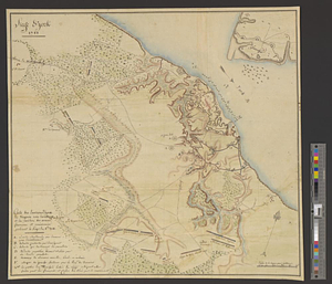
Situation des posten zu Denyses Ferry auf Long Island wie solcher den 7ten October 1781 von furste : Braunshweig und Hessen...
1135.
Situation of ye rebels just before the attack upon Trenton
1136.
Sketch from information of the different roads about Freehold in the Jerseys
1137.
Sketch from information of the different roads about Freehold in the Jerseys
1138.
Sketch of different passes into Canada from our lower provinces
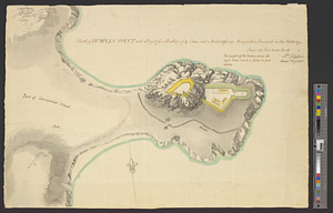
1139.
Sketch of Dumplin Point with a project for a battery of 4 guns and a redout for 90 men; with a barrack in the battery
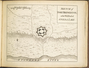
1140.
Sketch of Fort Brewerton at the west end of Oneda Lake
‹ Prev
Next ›
1
2
…
53
54
55
56
57
58
59
60
61
62
63
![Scetch [sic] of the blockhouse at the east of Oneda Lake](https://bpldcassets.blob.core.windows.net/derivatives/metadata/commonwealth-oai:zs2626251/image_thumbnail_300.jpg)