Toggle navigation
LMEC Home
Exhibitions
Georeferencing
Tools for Teachers
Collections
My Favorites
Sign Up / Log In
Search
Search the map portal
Map Collection
Map Collection
Map Sets
Search
Search
Search for
Search In
All Fields
Creator
Title
Subject
Place
Search All Digital Collections
Advanced Search
997 Results
My Search
Start Over
More Like
commonwealth-oai:dn401x058
Remove constraint More Like: commonwealth-oai:dn401x058
Filter your Search
Place
North and Central America
969
United States
708
Canada
205
New York
192
Quebec
111
Massachusetts
110
Suffolk (county)
95
Boston
88
more
Place
»
Topic
United States--History--Revolution, 1775-1783--Maps
328
United States--History--French and Indian War, 1754-1763--Maps
149
Charlestown (Boston, Mass.)--Maps
66
Saint Lawrence River--Maps
43
City planning--Massachusetts--Boston--Maps
34
Newport (R.I.)--Maps
27
New York (State)--Maps
24
Urban renewal--Massachusetts--Boston--Maps
23
more
Topic
»
Date
Date range begin
–
Date range end
Current results range from
1700
to
1992
View distribution
Creator
Boston Redevelopment Authority
36
Rocque, Mary Ann
29
Holland, Samuel, 1728-1801
25
Bellin, Jacques Nicolas, 1703-1772
24
Jefferys, Thomas, -1771
24
Montrésor, John, 1736-1799
24
Clinton, Henry, Sir, 1738?-1795
19
Robert Sayer and John Bennett (Firm)
16
more
Creator
»
Format
Maps/Atlases
980
Drawings/Illustrations
12
Documents
5
Manuscripts
4
Prints
1
Georeferenced
Yes
6
No
991
Collection
American Revolutionary War-Era Maps
928
William L. Clements Library Collection
909
Boston and New England Maps
68
Urban Maps
64
Norman B. Leventhal Map & Education Center Collection
45
Boston Redevelopment Authority Collection
37
American Antiquarian Society Collection
7
Newberry Library Collection
3
more
Collection
»
Available to use
No known restrictions
71
Creative Commons license
6
Search Constraints
Sort by relevance
relevance
title
date (asc)
date (desc)
Number of results to display per page
20 per page
10
per page
20
per page
50
per page
100
per page
View results as:
grid view
map view
Search Results
81.
Map of the powers at war with Great Britain, 1783
82.
Monmouth County, New Jersey
83.
Moore's sketch of the navigation of the Highlands
84.
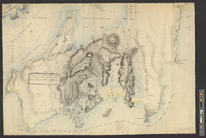
Narragansett Bay and Rhode Island
85.
A new and correct plan of the town of Boston
86.
The New York campaign of 1776
87.
The New York campaign of 1776
88.
Newark Bay and its immediate vicinity
89.
Newark, New Jersey
90.
Newport and its environs, ca. 1778
91.
Newport County, ca. 1779
92.
Northern New Jersey
93.
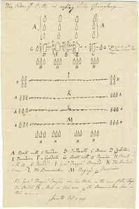
The order of battle in crossing Lake Champlane
94.
Original plan of Brentons Neck; and all the ground to the southward of the town of New-port Rhode Island, 1779
95.
Part of modern Brunswick County
96.
Part of modern Brunswick County
97.
Part of modern Charleston County
98.
Part of modern Monmouth County, 1778
99.
Part of modern Westchester County
100.
Part of modern Westchester County
‹ Prev
Next ›
1
2
3
4
5
6
7
8
9
…
49
50