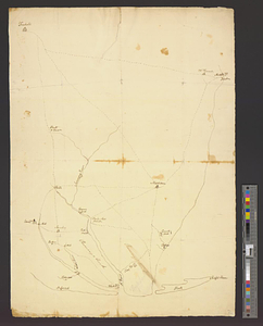
Monmouth County, New Jersey

This map is also available in American Revolutionary Geographies Online (ARGO), a collections portal especially built for material relating to the American Revolutionary War Era. Visit ARGO to learn more about this item and explore the historical geography of North America in the late eighteenth century.
Item Information
- Title:
- Monmouth County, New Jersey
- Title (alt.):
-
Northeastern New Jersey
- Creator:
- Laurence, Elisha
- Name on Item:
-
Elisha Laurence lt. coll: 1 Battn. N. Jersey Volunteers
- Date:
-
[1770–1779]
- Format:
-
Maps/Atlases
- Genre:
-
Manuscript maps
- Location:
- William L. Clements Library
- Collection (local):
-
William L. Clements Library Collection
- Subjects:
-
Roads--New Jersey--Monmouth County--Maps
Monmouth County (N.J.)--Maps
United States--History--Revolution, 1775-1783--Maps
- Places:
-
New JerseyMonmouth (county)
- Extent:
- 1 ms. map ; 71 x 50.4 cm.
- Terms of Use:
-
The University of Michigan Library provides access to these materials for educational and research purposes. These materials may be under copyright. If you decide to use any of these materials, you are responsible for making your own legal assessment and securing any necessary permission. If you have questions about the collection, please contact the William L. Clements Library.
Contact host institution for more information.
- Scale:
-
Scale 1:63,600.
- Language:
-
English
- Catalog Record:
-
Catalog record
- Notes:
-
Pen and ink, partly topographical map of the roads and distances, mostly in Monmouth County, northern New Jersey, from Monmouth Court House to Sandy Hook.
Many taverns, churches, and houses are indicated by name and numbers placed on many of the roads presumably corresponded to references, which are not with the map.
A few notations provide information on Continental troops at those points.
Clinton Maps 237.
- Notes (date):
-
This date is inferred.
- Identifier:
-
8305
- Barcode:
-
B2680854