Toggle navigation
LMEC Home
Exhibitions
Georeferencing
Tools for Teachers
Collections
My Favorites
Sign Up / Log In
Search
Search the map portal
Map Collection
Map Collection
Map Sets
Search
Search
Search for
Search In
All Fields
Creator
Title
Subject
Place
Search All Digital Collections
Advanced Search
946 Results
My Search
Start Over
More Like
commonwealth-oai:c534kn48m
Remove constraint More Like: commonwealth-oai:c534kn48m
Filter your Search
Place
North and Central America
910
United States
629
Canada
220
New York
194
Quebec
121
Saint Lawrence River
66
Pennsylvania
60
New Jersey
54
more
Place
»
Topic
United States--History--Revolution, 1775-1783--Maps
305
United States--History--French and Indian War, 1754-1763--Maps
149
Saint Lawrence River--Maps
67
Newport (R.I.)--Maps
27
New York (State)--Maps
24
Québec (Québec)--Maps
24
Hudson River (N.Y. and N.J.)--Maps
21
Louisbourg (N.S.)--Maps
20
more
Topic
»
Date
Date range begin
–
Date range end
Current results range from
1700
to
1923
View distribution
Creator
Montrésor, John, 1736-1799
29
Rocque, Mary Ann
29
Bellin, Jacques Nicolas, 1703-1772
28
Holland, Samuel, 1728-1801
28
Jefferys, Thomas, -1771
26
Clinton, Henry, Sir, 1738?-1795
19
Robert Sayer and John Bennett (Firm)
17
Cook, James, 1728-1779
13
more
Creator
»
Format
Maps/Atlases
930
Drawings/Illustrations
11
Documents
5
Manuscripts
1
Prints
1
Georeferenced
No
946
Collection
American Revolutionary War-Era Maps
934
William L. Clements Library Collection
909
Library and Archives Canada Collection
17
Norman B. Leventhal Map & Education Center Collection
12
MacLean Collection Map Library
3
New York Public Library Collection
3
Maps from AAS
2
Boston and New England Maps
1
Available to use
No known restrictions
12
Creative Commons license
3
Search Constraints
Sort by relevance
relevance
title
date (asc)
date (desc)
Number of results to display per page
20 per page
10
per page
20
per page
50
per page
100
per page
View results as:
grid view
map view
Search Results
21.
Map from Albany to Crown Point
22.
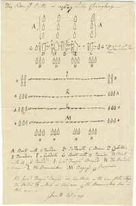
The order of battle in crossing Lake Champlane
23.
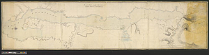
Plan of part of Lake Champlain from Crown Point to Tienderoga
24.
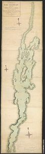
A survey of Lake Champlain including Crown Point and St: John's : surveyed by order of his excellency Major Genl: Sir Jeffery...
25.
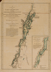
A survey of Lake Champlain, including Lake George, Crown Point and St. John : surveyed by order of his excellency Major-General...
26.
The Cedres
27.
A plan of a rout from Fort Pownall on the river Penobscot in New England to Quebec and from Quebec to Fort Pownall : taken by...
28.
Sketch of different passes into Canada from our lower provinces
29.
Topographical map of the province of New Hampshire, including Montresor's survey of the St. Lawrence and the Kennebec route to...
30.
Channels around the Island of Orleans
31.
Copie de la carte de Monsieur Klam ou l'on voit les sources e la riviere d'Orange suivant de nouvelles observation
32.
Draught of the river St. Lawrence from Lake Ontario to Montreal
33.
Gaspee Bay
34.
Hare Island; Pointe aux Allouettes of Larks Point; English Bank
35.
Manicouagan Shoals; Havre St. Nicholas; Bay of the Seven Islands
36.
Parish of Batiscant. Parish of St. Pierre Becquet. Parish of Champlain. Parish of Gentilly
37.
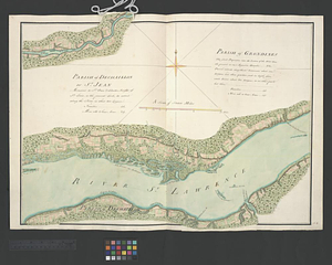
Parish of Dechaillon or St. Jean. Parish of Grondines
38.
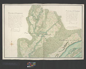
Parish of Dechambeaux. Parish of Cape Sante. Parish of Lotbinière. Parish of St. Croix
39.
Parish of L'Assomption. Parish of St. Sulpice
40.
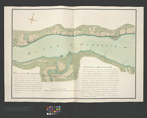
Parish of Magdelaine. Parish of Becancour
‹ Prev
Next ›
1
2
3
4
5
6
…
47
48