Toggle navigation
LMEC Home
Exhibitions
Georeferencing
Tools for Teachers
Collections
My Favorites
Sign Up / Log In
Search
Search the map portal
Map Collection
Map Collection
Map Sets
Search
Search
Search for
Search In
All Fields
Creator
Title
Subject
Place
Search All Digital Collections
Advanced Search
949 Results
My Search
Start Over
More Like
commonwealth-oai:b5648r764
Remove constraint More Like: commonwealth-oai:b5648r764
Filter your Search
Place
North and Central America
915
United States
641
Canada
222
New York
193
Quebec
111
Pennsylvania
60
New Jersey
54
Nova Scotia
48
more
Place
»
Topic
United States--History--Revolution, 1775-1783--Maps
306
United States--History--French and Indian War, 1754-1763--Maps
162
Saint Lawrence River--Maps
46
Newport (R.I.)--Maps
27
Québec (Québec)--Maps
27
New York (State)--Maps
25
Hudson River (N.Y. and N.J.)--Maps
21
East (U.S.)--Maps
20
more
Topic
»
Date
Date range begin
–
Date range end
Current results range from
1700
to
1990
View distribution
Creator
Jefferys, Thomas, -1771
29
Rocque, Mary Ann
29
Holland, Samuel, 1728-1801
26
Montrésor, John, 1736-1799
25
Bellin, Jacques Nicolas, 1703-1772
24
Clinton, Henry, Sir, 1738?-1795
19
Robert Sayer and John Bennett (Firm)
15
Orme, Robert, -1781
14
more
Creator
»
Format
Maps/Atlases
933
Drawings/Illustrations
11
Documents
5
Prints
1
Georeferenced
Yes
2
No
947
Collection
American Revolutionary War-Era Maps
939
William L. Clements Library Collection
909
Norman B. Leventhal Map & Education Center Collection
14
Library and Archives Canada Collection
9
Richard H. Brown Revolutionary War Map Collection at Mount Vernon
5
American Antiquarian Society Collection
4
Library of Congress Collection
3
MacLean Collection Map Library
2
more
Collection
»
Available to use
No known restrictions
16
Creative Commons license
8
Search Constraints
Sort by relevance
relevance
title
date (asc)
date (desc)
Number of results to display per page
20 per page
10
per page
20
per page
50
per page
100
per page
View results as:
grid view
map view
Search Results
41.
The harbour of Halifax
42.
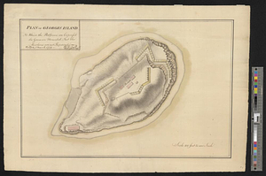
Plan of Georges Island : NB where the platforms are expres'd the guns are mounted but the merlons are not repaired
43.
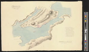
Plan of the harbor of Halifax in Nova Scotia
44.
Plan of the harbour of Halifax
45.
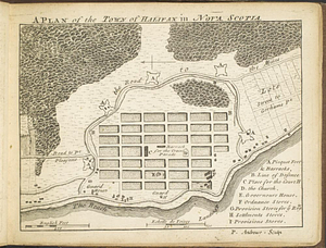
A plan of the town of Halifax in Nova Scotia
46.
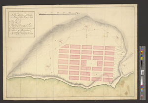
A plan of the town of Halifax in Nova Scotia August 1749
47.
Plan von dem schiff-bauplatz bei Hallifax in Neuscholland
48.
Plan von Halifax in Nord-America
49.
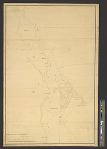
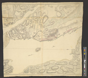
A sketch of Hallifax with its environs and the works, as executed in June 1776
50.
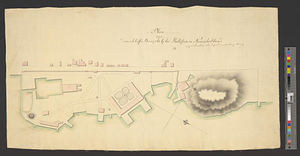
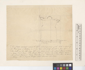
This sketch represents nearly the figure and proportions of the work in front of the dock yard at Hallifax as it was traced and...
51.
Map of the powers at war with Great Britain, 1783
52.
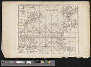
A new & accurate chart of the western or Atlantic Ocean : drawn from the most approved modern map &c.
53.
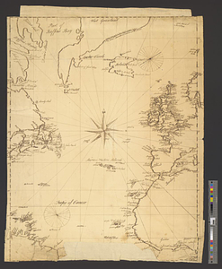
North Atlantic Ocean, ca. 1785
54.
Triangles on Mercator projection between St. Augustine and Cape Breton and St. Augustine and Cape Ortegal
55.
Cantonment of the forces in N. America 1766
56.
The United States of America with the British possessions of Canada, Nova Scotia, New Brunwsick, and Newfoundland, divided with...
57.
Louisbourg, latitude 45⁰ 50' north
58.
Map of the coast of Cape Breton from Fort William to Louisbourg
59.
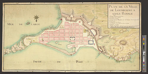
Plan de la ville de Louisbourg à l'Isle Royale
60.
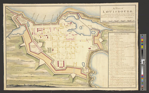
A plan of Louisbourg : intended only to shew by strong red the publick buildings lately erected; and by the faint red such as...
‹ Prev
Next ›
1
2
3
4
5
6
7
…
47
48