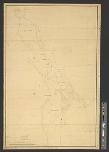
Plan of the harbour of Halifax
This map is also available in American Revolutionary Geographies Online (ARGO), a collections portal especially built for material relating to the American Revolutionary War Era. Visit ARGO to learn more about this item and explore the historical geography of North America in the late eighteenth century.
Item Information
- Title:
- Plan of the harbour of Halifax
- Contributor:
- Montrésor, John, 1736-1799
- Creator:
- Rivez, Charles
- Date:
-
[ca. 1757]
- Format:
-
Maps/Atlases
- Genre:
-
Manuscript maps
- Location:
- William L. Clements Library
- Collection (local):
-
William L. Clements Library Collection
- Subjects:
-
Halifax (N.S.)--Maps
- Places:
-
CanadaNova Scotia (province)Halifax
- Extent:
- 1 ms. map : col. ; 71.5 x 45 cm
- Terms of Use:
-
The University of Michigan Library provides access to these materials for educational and research purposes. These materials may be under copyright. If you decide to use any of these materials, you are responsible for making your own legal assessment and securing any necessary permission. If you have questions about the collection, please contact the William L. Clements Library.
Contact host institution for more information.
- Scale:
-
Scale 1:40,000,000.
- Language:
-
English
- Catalog Record:
-
Catalog record
- Notes:
-
Finished, colored chart of Halifax Harbor and Bedford Basin showing soundings and locations of several fortifications.
Signed below title: John Montresor engineer.
Script is in hand of Charles Rivez and is identical to Huntington map HM 15419.
Probably drawn at the time of 1757 Loudon expedition to Halifax.
Clinton Maps 5.
- Identifier:
-
7497
- Barcode:
-
B1938051


