Toggle navigation
LMEC Home
Exhibitions
Georeferencing
Tools for Teachers
Collections
My Favorites
Sign Up / Log In
Search
Search the map portal
Map Collection
Map Collection
Map Sets
Search
Search
Search for
Search In
All Fields
Creator
Title
Subject
Place
Search All Digital Collections
Advanced Search
947 Results
My Search
Start Over
More Like
commonwealth-oai:b5648r764
Remove constraint More Like: commonwealth-oai:b5648r764
Filter your Search
Place
North and Central America
913
United States
641
Canada
222
New York
193
Quebec
111
Pennsylvania
60
New Jersey
54
Nova Scotia
48
more
Place
»
Topic
United States--History--Revolution, 1775-1783--Maps
305
United States--History--French and Indian War, 1754-1763--Maps
161
Saint Lawrence River--Maps
46
Newport (R.I.)--Maps
27
Québec (Québec)--Maps
27
New York (State)--Maps
25
Hudson River (N.Y. and N.J.)--Maps
21
East (U.S.)--Maps
20
more
Topic
»
Date
Date range begin
–
Date range end
Current results range from
1700
to
1990
View distribution
Creator
Rocque, Mary Ann
29
Jefferys, Thomas, -1771
28
Holland, Samuel, 1728-1801
26
Montrésor, John, 1736-1799
25
Bellin, Jacques Nicolas, 1703-1772
24
Clinton, Henry, Sir, 1738?-1795
19
Robert Sayer and John Bennett (Firm)
15
Orme, Robert, -1781
14
more
Creator
»
Format
Maps/Atlases
931
Drawings/Illustrations
11
Documents
5
Prints
1
Georeferenced
Yes
2
No
945
Collection
American Revolutionary War-Era Maps
937
William L. Clements Library Collection
909
Norman B. Leventhal Map & Education Center Collection
14
Library and Archives Canada Collection
9
Richard H. Brown Revolutionary War Map Collection at Mount Vernon
5
American Antiquarian Society Collection
4
Library of Congress Collection
3
Maritime Charts and Atlases
2
more
Collection
»
Available to use
No known restrictions
16
Creative Commons license
8
Search Constraints
Sort by relevance
relevance
title
date (asc)
date (desc)
Number of results to display per page
20 per page
10
per page
20
per page
50
per page
100
per page
View results as:
grid view
map view
Search Results
201.
Annapolis Royal ; St. Mary's Bay
202.
Annapolis Royal ; St. Mary's Bay
203.
A general plan of Annapolis Royal
204.
Amerique Septentrionale
205.
A chart of the gulf stream
206.
[Chart of the Gulf Stream]
207.
Map of the United States of America, the British provinces, Mexico, the West Indies and Central America, with part of New...
208.
Naval chart of the Pacific and western Atlantic
209.
A new and accurate map of the English empire in North America : representing their rightful claim as confirm'd by charters, and...
210.
Track of the U.S. surveying brig Dolphin : from September 1851 to July 1852 : [Atlantic Ocean]
211.
Sketch of the town and harbour of Halifax
212.
Gulf of St. Lawrence, Cape Breton Island, Louisburg Harbor : from British surveys
213.
Map of the route to the Kansas gold mines : prepared from government and other surveys : showing the most direct railroad...
214.
Map showing cotton growing region of the United States and means of transportation by water and rail
215.
A new map of the United States including part of Louisiana : from the best authorities
216.
Southern Railway system
217.
Vereinigte Staaten von Nord-Amerika in 6 blattern, bl. 3
218.
Map of Quebec City with plans of the citadel by Captain Samuel Holland for Report of the government of Quebec and dependencies
219.
Plan of Quebec
220.
Plan of the town of Quebec the capital of Canada in North America : with the bason and a part of the adjacent country shewing...
‹ Prev
Next ›
1
2
…
7
8
9
10
11
12
13
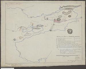
14
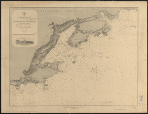
15
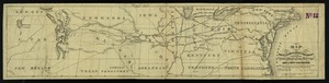
…
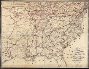
47
48


![[Chart of the Gulf Stream]](https://bpldcassets.blob.core.windows.net/derivatives/images/commonwealth:z603vr47j/image_thumbnail_300.jpg)