Toggle navigation
LMEC Home
Exhibitions
Georeferencing
Tools for Teachers
Collections
My Favorites
Sign Up / Log In
Search
Search the map portal
Map Collection
Map Collection
Map Sets
Search
Search
Search for
Search In
All Fields
Creator
Title
Subject
Place
Search All Digital Collections
Advanced Search
967 Results
My Search
Start Over
More Like
commonwealth-oai:7h14fn780
Remove constraint More Like: commonwealth-oai:7h14fn780
Filter your Search
Place
North and Central America
941
United States
677
New York
247
Canada
208
Quebec
112
Pennsylvania
69
New Jersey
61
Nova Scotia
48
more
Place
»
Topic
United States--History--Revolution, 1775-1783--Maps
305
United States--History--French and Indian War, 1754-1763--Maps
150
New York (State)--Maps
81
Saint Lawrence River--Maps
43
Newport (R.I.)--Maps
27
Pennsylvania--Maps
27
Hudson River (N.Y. and N.J.)--Maps
23
New England--Maps
21
more
Topic
»
Date
Date range begin
–
Date range end
Current results range from
1700
to
1976
View distribution
Creator
Rocque, Mary Ann
29
Holland, Samuel, 1728-1801
26
Bellin, Jacques Nicolas, 1703-1772
25
Montrésor, John, 1736-1799
25
Jefferys, Thomas, -1771
24
Clinton, Henry, Sir, 1738?-1795
19
Robert Sayer and John Bennett (Firm)
15
Hills, John, active 1777-1819
13
more
Creator
»
Format
Maps/Atlases
951
Drawings/Illustrations
11
Documents
5
Manuscripts
2
Prints
1
Georeferenced
Yes
7
No
960
Collection
American Revolutionary War-Era Maps
921
William L. Clements Library Collection
909
Norman B. Leventhal Map & Education Center Collection
47
Boston and New England Maps
13
American Antiquarian Society Collection
9
Massachusetts Historical Society Map Collection
1
New-York Historical Society Collection
1
Available to use
No known restrictions
48
Creative Commons license
1
Search Constraints
Sort by relevance
relevance
title
date (asc)
date (desc)
Number of results to display per page
20 per page
10
per page
20
per page
50
per page
100
per page
View results as:
grid view
map view
Search Results
741.
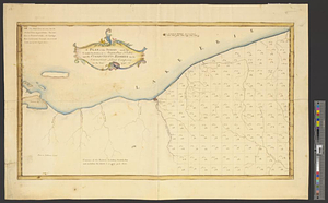
A plan of the settled part of Canada reduced from the large survey made in the years 1760 & 1761 by order of General Murray...
742.
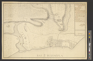
Plan of the siege of Fort George and works adjacent at Pensacola in West Florida, 1781
743.
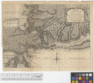
A plan of the Straits of St. Mary and Michilimakinac to shew the situation & importance of the two westernmost settlements of...
744.
A plan of the survey made by, & under the direction of Augustus Porter upon the Connecticut Reserve for the Connecticut Land...
745.
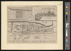
Plan of the town & fortifications of Montreal, or Ville Marie in Canada
746.
Plan of the town & fortifications of Montreal or Ville Marie in Canada
747.
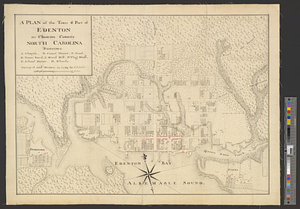
A plan of the town & port of Edenton in Chowan County, North Carolina : survey'd and drawn in 1769
748.
A plan of the town and chart of the harbour of Boston exhibiting a view of the islands castle forts and entrances into the said...
749.
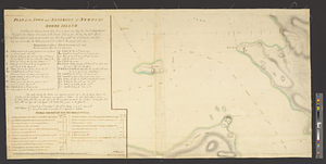
Plan of the town and environs of Newport, Rhode Island : exhibiting its defenses formed before the 8th of August 1778 when the...
750.
Plan of the town and environs of Newport, Rhode Island : exhibiting its defenses formed before the 8th of August 1778 when the...
751.
A plan of the town and fort of Carillon at Ticonderoga : with the attack made by the British army commanded by Genl....
752.
Plan of the town and fortifications of Montréal or Ville Marie in Canada
753.
A plan of the town and harbour of Boston and the country adjacent with the road from Boston to Concord shewing the place of the...
754.
Plan of the town of Boston
755.
Plan of the town of Boston with the attack on Bunkers-Hill in the peninsula of Charlestown the 17th of June 1775
756.
A plan of the town of Dracut protracted by a scale of 200 rods to an inch : taken in Octobr. 1791
757.
A plan of the town of Halifax in Nova Scotia
758.
A plan of the town of Halifax in Nova Scotia August 1749
759.
A plan of the town of Medford in the county of Middlesex and commonwealth of Massachusetts containing 5631 acres including...
760.
Plan of the town of Montreal
‹ Prev
Next ›
1
2
…
34
35
36
37
38
39
40
41
42
…
48
49