Toggle navigation
LMEC Home
Exhibitions
Georeferencing
Tools for Teachers
Collections
My Favorites
Sign Up / Log In
Search
Search the map portal
Map Collection
Map Collection
Map Sets
Search
Search
Search for
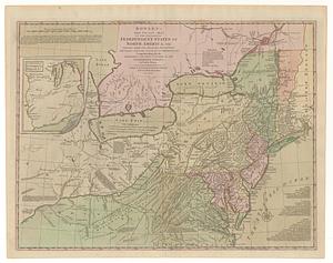
Search In
All Fields
Creator
Title
Subject
Place
Search All Digital Collections
Advanced Search
349 Results
My Search
Start Over
More Like
commonwealth:z603vs570
Remove constraint More Like: commonwealth:z603vs570
Filter your Search
Place
North and Central America
282
United States
212
Northeastern United States
44
New York
41
Canada
37
Suffolk (county)
31
North America
30
Boston
29
more
Place
»
Topic
Northeastern States--Maps--Early works to 1800
46
North America--Maps--Early works to 1800
21
Boston (Mass.)--History--Revolution, 1775-1783--Maps--Early works to 1800
16
New England--Maps--Early works to 1800
16
United States--Maps--Early works to 1800
16
New York (State)--Maps--Early works to 1800
12
United States--History--Revolution, 1775-1783--Maps--Early works to 1800
10
Vues d'optique
10
more
Topic
»
Date
Date range begin
–
Date range end
Current results range from
1635
to
1850
View distribution
Creator
Faden, William, 1749-1836
33
Jefferys, Thomas, -1771
32
Le Rouge, Georges-Louis
22
Des Barres, Joseph F. W. (Joseph Frederick Wallet), 1722-1824
21
Sayer, Robert, 1725-1794
20
Korn, Christoph Heinrich, 1726-1783
11
Raspe, Gabriel Nicolaus, 1712-1785
11
Simcoe, John Graves, 1752-1806
10
more
Creator
»
Format
Maps/Atlases
306
Prints
32
Manuscripts
24
Drawings/Illustrations
9
Books
2
Georeferenced
Yes
13
No
336
Collection
American Revolutionary War-Era Maps
332
Richard H. Brown Revolutionary War Map Collection at Mount Vernon
293
Norman B. Leventhal Map & Education Center Collection
28
MacLean Collection Map Library
12
New York Public Library Collection
11
Mapping Boston Collection
7
Maritime Charts and Atlases
5
Boston and New England Maps
4
more
Collection
»
Available to use
Creative Commons license
311
No known restrictions
23
Search Constraints
Sort by relevance
relevance
title
date (asc)
date (desc)
Number of results to display per page
20 per page
10
per page
20
per page
50
per page
100
per page
View results as:
grid view
map view
Search Results
1.
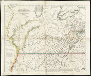
A new map of the western parts of Virginia, Pennsylvania, Maryland and North Carolina : comprehending the river Ohio, and all...
2.
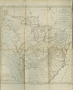
A map of the western part of the territories belonging to the United States of America : drawn from the best authorities
3.
Carte d'une partie du Nord Amerique dans la quelle se trouvent les isles et les provinces suivantes : l'Isle de la Terre-Neuve...
4.
A map of the Province of New-York : reduc'd from the large drawing of that province, compiled from actual surveys by order of...
5.
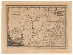
MAP of the Western parts of the COLONY of VIRGINIA, as far as the Mississipi
6.
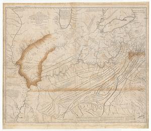
A new map of the western parts of Virginia, Pennsylvania, Maryland and North Carolina comprehending the river Ohio, and all the...
7.
Gli Stati Uniti dell' America delineati fulle ultime offervazioni : terzo foglio che comprende parte della Virginia e della...
8.
Cours de l'Ohio depuis sa source jusqu'a sa jonction avec la Riviere d'Ouabache et les pais voisons
9.
Partie de l'Amérique septentrionale, qui comprend le cours de l'Ohio, la Nlle. Angleterre, la Nlle York, le New Jersey, la...
10.
Amplissimae regionis Mississipi seu provinciae Ludovicianae â R.P. Ludovico Hennepin Francisc. Miss. in America septentrionali...
11.
Amplissimae regionis Mississipi seu Provinciae Ludovicianae â R.P. Ludovico Hennepin Francisc Miss in America Septentrionali...
12.
Carte de la Louisiane et du cours de Mississipi
13.
Carte de la Louisiane et du cours du Mississipi avec les colonies anglaises
14.
A map of Carolana and of the river Meschacebe &c
15.
A map of Louisiana and of the River Mississipi
16.
Bowles's new pocket map of the following independent states of North America, viz. Virginia, Maryland, Delaware, Pensylvania,...
17.
Carta della Nuova Inghilterra, Nuova Yorc, e Pensilvania
18.
Carte de la Nouvelle Angleterre, New York, Pensilvanie et Nouveau Jersay suivant les cartes angloises
19.
Carte de la partie nord, des Etats Unis, de l'Amérique Septentrionale
20.
Carte des Etats-unis : provinces septentrionales
‹ Prev
Next ›
1
2
3
4
5
…
17
18