Toggle navigation
LMEC Home
Exhibitions
Georeferencing
Tools for Teachers
Collections
My Favorites
Sign Up / Log In
Search
Search the map portal
Map Collection
Map Collection
Map Sets
Search
Search
Search for
Search In
All Fields
Creator
Title
Subject
Place
Search All Digital Collections
Advanced Search
100 Results
My Search
Start Over
More Like
commonwealth:z603vr22p
Remove constraint More Like: commonwealth:z603vr22p
Filter your Search
Place
North and Central America
100
New York
99
United States
99
Manhattan
54
Fort Washington (historical)
9
Brooklyn (borough)
8
New Jersey
8
Bronx
5
more
Place
»
Topic
Manhattan (New York, N.Y.)--Maps
51
New York (N.Y.)--Maps
48
United States--History--Revolution, 1775-1783--Maps
19
Brooklyn (New York, N.Y.)--Maps
9
Fort Washington (New York, N.Y.)--Maps
8
Railroads--New York (State)--New York--Maps
8
New York Harbor (N.Y. and N.J.)--Maps
7
Real property--New York (State)--New York--Maps
7
more
Topic
»
Date
Date range begin
–
Date range end
Current results range from
1733
to
1939
View distribution
Creator
Kitchin, Thomas, 1719-1784
5
Dripps, M. (Matthew)
4
Hayward, George, approximately 1800-
4
Andrews, Peter, active 1765-1782
3
Martin, Reinhard Jacob
3
Rand McNally and Company
3
Ratzer, Bernard
3
Amherst, Jeffery Amherst, Baron, 1717-1797
2
more
Creator
»
Format
Maps/Atlases
100
Manuscripts
3
Georeferenced
Yes
12
No
88
Collection
Norman B. Leventhal Map & Education Center Collection
50
American Revolutionary War-Era Maps
46
Urban Maps
33
William L. Clements Library Collection
27
New York Public Library Collection
14
American Antiquarian Society Collection
4
New-York Historical Society Collection
4
Maritime Charts and Atlases
2
more
Collection
»
Available to use
No known restrictions
54
Creative Commons license
14
Search Constraints
Sort by relevance
relevance
title
date (asc)
date (desc)
Number of results to display per page
20 per page
10
per page
20
per page
50
per page
100
per page
View results as:
grid view
map view
Search Results
61.
Insurance maps of the city of New York
62.
Isle de Newyork : reconnaissance des ouvrages du nord de lisle de Newyork faite en presence des Généraux, Wasington et...
63.
Kings Bridge
64.
Land holdings on Kip's Bay, Manhattan Island
65.
Manhattan : first city of America
66.
Map of New York City showing concrete socialism in red, and private enterprises in white, 1895
67.
Map of New York I. with the adjacent rocks and other remarkable parts of Hell-Gate
68.
A map of New York which is published by the Washington Square Bookshop
69.
Map of New-York
70.
Map of the cities of New York, Brooklyn & Jersey City
71.
A map of the country adjacent to Kingsbridge, surveyed by order of his excellency General Sir Henry Clinton K.B., commander in...
72.
Map of the original grants of village lots from the Dutch West India Company to the inhabitants of New-Amsterdam (now New-York)...
73.
Map of the part of the boroughs of Manhattan and Bronx, New York City
74.
New York City : (southern part)
75.
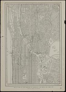
[New York City, from the Battery to 63rd street]
76.
Part of New York City
77.
Part of the modern counties of Westchester and Bronx
78.
A pictorial map of that portion of New York City known as Manhattan, also showing parts of the Bronx
79.
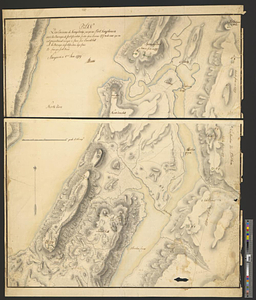
Plan des environs de Kingsbridge jusqu'au Fort Knyphausen avec les ouvrages de fortification faites dans l'année 1779 & de ceux...
80.
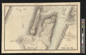
Plan des ouvrages faites en front du fort Knyphausen, New Yorck ce 4 me. Novr 1779
‹ Prev
Next ›
1
2
3
4
5


![[New York City, from the Battery to 63rd street]](https://bpldcassets.blob.core.windows.net/derivatives/images/commonwealth:4m90f274r/image_thumbnail_300.jpg)