Toggle navigation
LMEC Home
Exhibitions
Georeferencing
Tools for Teachers
Collections
My Favorites
Sign Up / Log In
Search
Search the map portal
Map Collection
Map Collection
Map Sets
Search
Search
Search for
Search In
All Fields
Creator
Title
Subject
Place
Search All Digital Collections
Advanced Search
50 Results
My Search
Start Over
More Like
commonwealth:z603vq44h
Remove constraint More Like: commonwealth:z603vq44h
Filter your Search
Place
North and Central America
43
New York
34
United States
31
New Jersey
12
North America
9
New England
8
Northeastern United States
8
Pennsylvania
5
more
Place
»
Topic
New York (State)--Maps--Early works to 1800
34
New Jersey--Maps--Early works to 1800
12
Northeastern States--Maps--Early works to 1800
9
New England--Maps--Early works to 1800
8
New York (State)--Administrative and political divisions--Maps--Early works to 1800
6
North America--Maps--Early works to 1800
6
Pennsylvania--Maps--Early works to 1800
5
Real property--New York (State)--Maps--Early works to 1800
5
more
Topic
»
Date
Date range begin
–
Date range end
Current results range from
1636
to
1798
View distribution
Creator
Faden, William, 1749-1836
5
Sauthier, Claude Joseph
5
Montrésor, John, 1736-1799
4
Dury, Andrew
3
Kitchin, Thomas, 1719-1784
3
Le Rouge, Georges-Louis
3
Amherst, Jeffery Amherst, Baron, 1717-1797
2
Andrews, Peter, active 1765-1782
2
more
Creator
»
Format
Maps/Atlases
50
Georeferenced
Yes
2
No
48
Collection
American Revolutionary War-Era Maps
44
New York Public Library Collection
23
Norman B. Leventhal Map & Education Center Collection
13
MacLean Collection Map Library
8
Richard H. Brown Revolutionary War Map Collection at Mount Vernon
4
Mapping Boston Collection
2
Sidney R. Knafel Map Collection at Phillips Academy
2
Available to use
Creative Commons license
29
No known restrictions
11
Search Constraints
Sort by relevance
relevance
title
date (asc)
date (desc)
Number of results to display per page
20 per page
10
per page
20
per page
50
per page
100
per page
View results as:
grid view
map view
Search Results
21.
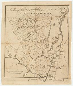
A map of Tottin & Crosfields purchase & the waters adjacent in the state of New-York
22.
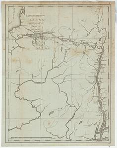
Map of western New York state, marking land plots around Lac Oneida
23.
New Engelland, New York, New Yersey und Pensilvania
24.
New England and New York
25.
Noua Anglia, Nouum Belgium, et Virginia
26.
Nouvelle Angleterre et Nouvel York
27.
Pas caert van Nieu Nederland, Virginia en Nieu Engelant
28.
La Pensilvania, la Nuova York, il Jersey Settentrio[na]le : con la parte occidentale del Connecticut, Massachusset-s-bay e...
29.
Pensylvania Nova Jersey et Nova York cum Regionibus ad Fluvium Delaware in America sitis
30.
Province de New-York en 4. feuilles
31.
Province de New-York en 4. feuilles
32.
Province de New-York en 4. feuilles par Montresor
33.
The provinces of New York, and New Jersey; with part of Pensilvania, and the governments of Trois Rivieres, and Montreal
34.
The southern part of the Province of New York : with part of the adjoining colonies
35.
An accurate map of the British Empire in Nth. America as settled by the preliminaries in 1762
36.
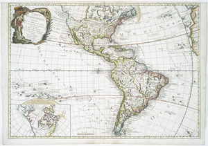
L'Amérique septentrionale
37.
Amérique Septentrionale publiée sous les auspices de Monseigneur le Duc d'Orleans prémier prince du sang
38.
Carte d'Amerique : divisée en ses principaux etats avec les nouvelles decouvertes faites au Nord et dans la Mer du Sud par les...
39.
Carte de la Louisiane et des pays voisins : dédiée à M. Rouillé, sécretaire d'État, ayant le Département de la marine
40.
Carte de la Louisiane et du cours du Mississipi avec les colonies anglaises
‹ Prev
Next ›
1
2
3


![La Pensilvania, la Nuova York, il Jersey Settentrio[na]le](https://bpldcassets.blob.core.windows.net/derivatives/images/commonwealth:z603vq53g/image_thumbnail_300.jpg)