Toggle navigation
LMEC Home
Exhibitions
Georeferencing
Tools for Teachers
Collections
My Favorites
Sign Up / Log In
Search
Search the map portal
Map Collection
Map Collection
Map Sets
Search
Search
Search for
Search In
All Fields
Creator
Title
Subject
Place
Search All Digital Collections
Advanced Search
236 Results
My Search
Start Over
More Like
commonwealth:z603vn753
Remove constraint More Like: commonwealth:z603vn753
Filter your Search
Place
North and Central America
215
United States
165
New England
94
Canada
28
Middle Atlantic
21
Massachusetts
13
New York
13
Boston Harbor
11
more
Place
»
Topic
Manuscript maps--Early works to 1800
138
New England--Maps--Early works to 1800
97
Middle Atlantic States--Maps--Early works to 1800
21
Northeastern States--Maps--Early works to 1800
10
New York (State)--Maps--Early works to 1800
8
Canada--Maps--Early works to 1800
7
North America--Maps--Early works to 1800
7
Añasco (P.R.)--Maps--Early works to 1800
6
more
Topic
»
Date
Date range begin
–
Date range end
Current results range from
1617
to
1999
View distribution
Creator
Dumont de Montigny
14
Adlum, John, 1759-1836
9
Bingham, William, 1752-1804
9
Jefferys, Thomas, d. 1771
9
Bowles, Carington, 1724-1793
5
Jefferys, Thomas, -1771
5
Bellin, Jacques Nicolas, 1703-1772
4
De Brahm, John Gerar William, 1717-approximately 1799
4
more
Creator
»
Format
Maps/Atlases
236
Manuscripts
139
Georeferenced
Yes
10
No
226
Collection
American Revolutionary War-Era Maps
186
Library of Congress Collection
97
Norman B. Leventhal Map & Education Center Collection
65
Newberry Library Collection
39
Boston and New England Maps
32
Maritime Charts and Atlases
27
Mapping Boston Collection
23
Sidney R. Knafel Map Collection at Phillips Academy
15
more
Collection
»
Available to use
Creative Commons license
132
No known restrictions
43
Search Constraints
Sort by relevance
relevance
title
date (asc)
date (desc)
Number of results to display per page
20 per page
10
per page
20
per page
50
per page
100
per page
View results as:
grid view
map view
Search Results
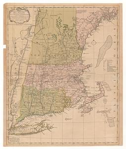
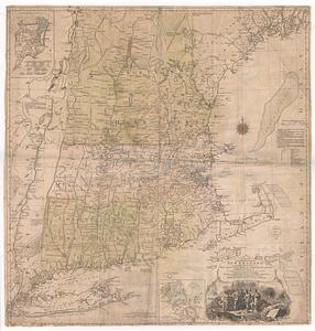
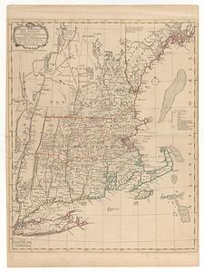
61.
A map of the most inhabited part of New England : containing the provinces of Massachusets Bay and New Hampshire, with the...
62.
A map of the most inhabited part of New England : containing the provinces of Massachusets Bay and New Hampshire, with the...
63.
A map of the most inhabited part of New England, containing the provinces of Massachusets Bay and New Hampshire, with the...
64.
A map of the most inhabited part of New England, containing the provinces of Massachusets Bay and New Hampshire, with the...
65.
A map of the most inhabited part of New England, containing the provinces of Massachusets Bay and New Hampshire, with the...
66.
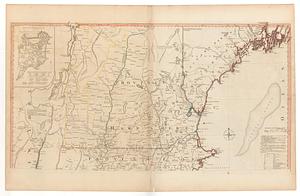
A map of the most inhabited part of New England containing the provinces of Massachusets Bay and New Hampshire with the...
67.
A map of the most inhabited part of New England, containing the provinces of Massachusets Bay and New Hampshire, with the...
68.
A map of the most inhabited part of New England, containing the provinces of Massachusetts Bay and New Hampshire, with the...
69.
Map of the northern, or, New England states of America, comprehending Vermont, New Hampshire, District of Main, Massachusetts,...
70.
Map of the northern, or, New England states of America, comprehending Vermont, New Hampshire, District of Main, Massachusetts,...
71.
A map of the Province of New York, with part of Pensilvania, and New England : from an actual survey by Captain Montresor,...
72.
A map of the Province of New York, with part of Pensilvania, and New England : from an actual survey by Captain Montresor,...
73.
A mapp of New England
74.
A mapp of New England
75.
A new and accurate map of the present seat of war in North America : from a late survey
76.
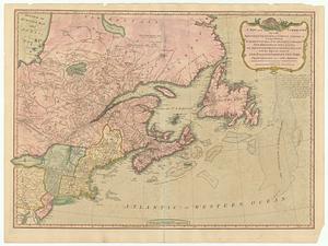
A new and correct map of the British colonies in North America : comprehending eastern Canada with the province of Quebec, New...
77.
A new chart of the coast of New England, Nova Scotia, New France or Canada, with the islands of Newfoundld. Cape Breton St....
78.
New Engelland, New York, New Yersey und Pensilvania
79.
New England : die mercklichsten dheile, also genennet durch den durchl: und mechtigen Prinzen und h.h. Carolus, Prinzen von...
80.
New England : the most remarqueable parts thus named by the high and mighty Prince Charles, prince of great Britaine
‹ Prev
Next ›
1
2
3
4
5
6
7
8
…
11
12


![A map of the most inhabited part of New England containing the provinces of Massachusets Bay and New Hampshire with the colonies of Connecticut and Rhode Island divided into counties and townships the w[h]ole composed from actual surveys and its situation adjusted by astronomical observations](https://bpldcassets.blob.core.windows.net/derivatives/images/commonwealth:6t053p316/image_thumbnail_300.jpg)