Toggle navigation
LMEC Home
Exhibitions
Georeferencing
Tools for Teachers
Collections
My Favorites
Sign Up / Log In
Search
Search the map portal
Map Collection
Map Collection
Map Sets
Search
Search
Search for
Search In
All Fields
Creator
Title
Subject
Place
Search All Digital Collections
Advanced Search
320 Results
My Search
Start Over
More Like
commonwealth:z603vg69x
Remove constraint More Like: commonwealth:z603vg69x
Filter your Search
Place
North and Central America
307
United States
275
New York
151
New Jersey
43
Canada
30
Hudson River
29
New England
25
Massachusetts
22
more
Place
»
Topic
New York (State)--Maps
85
New York (N.Y.)--Maps
48
United States--History--Revolution, 1775-1783--Maps
47
New Jersey--Maps
40
Hudson River (N.Y. and N.J.)--Maps
29
New England--Maps
27
United States--Maps
21
Railroads--New York (State)--Maps
20
more
Topic
»
Date
Date range begin
–
Date range end
Current results range from
1700
to
1976
View distribution
Creator
Kitchin, Thomas, 1719-1784
11
Reid, John, 1764?-1828
11
Bellin, Jacques Nicolas, 1703-1772
9
Farwell, John Whittemore, 1843-1929
9
Carey, Mathew, 1760-1839
6
Carleton, Osgood, 1742-1816
6
Tanner, Benjamin, 1775-1848
6
United States. Post Office Dept
6
more
Creator
»
Format
Maps/Atlases
320
Manuscripts
14
Drawings/Illustrations
1
Georeferenced
Yes
36
No
284
Collection
American Revolutionary War-Era Maps
220
Maps from AAS
138
Norman B. Leventhal Map & Education Center Collection
101
William L. Clements Library Collection
68
Urban Maps
21
Boston and New England Maps
15
MacLean Collection Map Library
7
New-York Historical Society Collection
3
more
Collection
»
Available to use
No known restrictions
104
Creative Commons license
4
Search Constraints
Sort by relevance
relevance
title
date (asc)
date (desc)
Number of results to display per page
20 per page
10
per page
20
per page
50
per page
100
per page
View results as:
grid view
map view
Search Results
61.
A compleat plan of part of the province of Pennsylvania East and West Jersey shewing the transactions of the royal army under...
62.
From Freehold toward Trenton
63.
An historical map of Pennsylvania : showing the Indian names of streams and villages, and paths of travel : the sites of old...
64.
Manuscript maps of U.S. states, possibly drawn by a schoolchild
65.
Map of American camp in New Jersey and surrounding countryside
66.
A map of the Delaware and Chesapeak bays with the peninsula between them
67.
Map of the rail roads of New Jersey 1887
68.
A new and accurate map of New Jersey, from the best authorities
69.
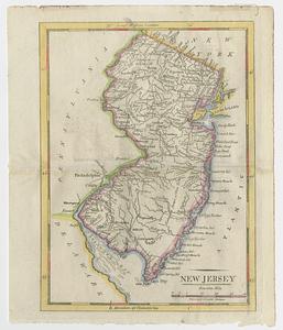
New Jersey
70.
New Jersey
71.
New Jersey showing forest area and its relation to the principal watersheds
72.
Northern New Jersey
73.
Northern New Jersey, showing the iron-ore & limestone districts
74.
Part of the modern counties of Monmouth, Middlesex, Somerset, Hunterdon, Mercer, Burlington, and Ocean in New Jersey and...
75.
A plan of the northern part of New Jersey : shewing the positions of the American and British armies after crossing the North...
76.
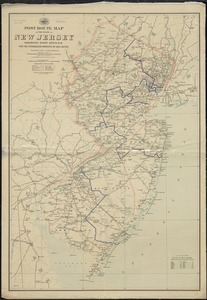
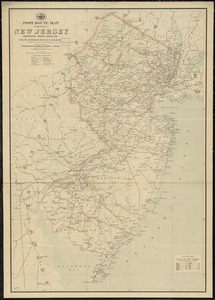
Post route map of the State of New Jersey showing post offices with the intermediate distances on mail routes in operation on...
77.
Post route map of the state of New Jersey showing post offices with the intermediate distances on mail routes in operation on...
78.
Post route map of the states of Pennsylvania, New Jersey, Delaware, and Maryland and of the District of Columbia with adjacent...
79.
The principal part of the province of New Jersey shewing the road and distances to the several towns between the North River...
80.
Rand, McNally & Co.'s New Jersey
‹ Prev
Next ›
1
2
3
4
5
6
7
8
…
15
16