Toggle navigation
LMEC Home
Exhibitions
Georeferencing
Tools for Teachers
Collections
My Favorites
Sign Up / Log In
Search
Search the map portal
Map Collection
Map Collection
Map Sets
Search
Search
Search for
Search In
All Fields
Creator
Title
Subject
Place
Search All Digital Collections
Advanced Search
8727 Results
My Search
Start Over
More Like
commonwealth:x633fb24z
Remove constraint More Like: commonwealth:x633fb24z
Filter your Search
Place
North and Central America
5,926
United States
4,844
Massachusetts
2,079
Europe
1,397
Suffolk (county)
1,046
Boston
1,019
Canada
449
Asia
439
more
Place
»
Topic
Boston (Mass.)--Maps
586
United States--Maps
282
Real property--Massachusetts--Boston--Maps
175
Massachusetts--Maps
162
Landowners--Massachusetts--Boston--Maps
133
North America--Maps--Early works to 1800
103
New England--Maps
102
Europe--Maps
80
more
Topic
»
Date
Date range begin
–
Date range end
Current results range from
1482
to
2023
View distribution
Creator
United States. Hydrographic Office
595
O.H. Bailey & Co
148
Des Barres, Joseph F. W. (Joseph Frederick Wallet), 1722-1824
123
United States. Post Office Dept
120
Ptolemy, 2nd cent
100
Walling, Henry Francis, 1825-1888
94
Geological Survey (U.S.)
86
Jefferys, Thomas, -1771
85
more
Creator
»
Format
Maps/Atlases
8,667
Manuscripts
215
Prints
56
Books
36
Objects/Artifacts
10
Drawings/Illustrations
8
Posters
5
Georeferenced
Yes
869
No
7,858
Collection
Norman B. Leventhal Map & Education Center Collection
8,714
Boston and New England Maps
2,233
Urban Maps
2,023
Maritime Charts and Atlases
1,083
American Revolutionary War-Era Maps
616
Boston Redevelopment Authority Collection
87
Mapping Boston Collection
19
Sidney R. Knafel Map Collection at Phillips Academy
13
Available to use
No known restrictions
8,553
Creative Commons license
66
Search Constraints
Sort by relevance
relevance
title
date (asc)
date (desc)
Number of results to display per page
20 per page
10
per page
20
per page
50
per page
100
per page
View results as:
grid view
map view
Search Results
5501.
North Atlantic track chart
5502.
North Atlantic--Azores, San Miguel : from a British survey in 1844
5503.
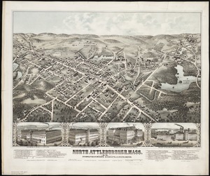
North Attleborough, Mass. 1878
5504.
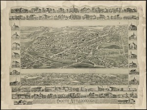
North Attleborough, Massachusetts : 1891
5505.
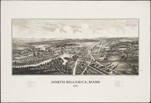
North Billerica, Mass : 1887
5506.
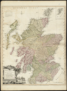
North Britain or Scotland divided into its counties : corrected from the best surveys & astronomical observations
5507.
North Brookfield, Mass : 1878
5508.
North Carolina
5509.
North Carolina & South Carolina
5510.
The north coast of the Gulf of Mexico, from St. Marks to Galveston
5511.
[North east coast of Nova Scotia and Northumberland Strait]
5512.
[North east coast of Nova Scotia and Northumberland Strait]
5513.
North east end of Lake Michigan including Grand and Little Traverse Bays and the Fox and Manitou Islands
5514.
North Easton, Massachusetts : 1891
5515.
North end of Lake Michigan including Green Bay and the straits of Mackinac
5516.
North end of Lake Michigan including the Beaver Island group
5517.
North end of Lake Michigan including the Beaver Island group
5518.
North Italy
5519.
North Korea
5520.
North Leominster, Mass
‹ Prev
Next ›
1
2
…
272
273
274
275
276
277
278
279
280
…
436
437


![[North east coast of Nova Scotia and Northumberland Strait]](https://bpldcassets.blob.core.windows.net/derivatives/images/commonwealth:ws859h21d/image_thumbnail_300.jpg)
![[North east coast of Nova Scotia and Northumberland Strait]](https://bpldcassets.blob.core.windows.net/derivatives/images/commonwealth:ws859h23z/image_thumbnail_300.jpg)