Toggle navigation
LMEC Home
Exhibitions
Georeferencing
Tools for Teachers
Collections
My Favorites
Sign Up / Log In
Search
Search the map portal
Map Collection
Map Collection
Map Sets
Search
Search
Search for
Search In
All Fields
Creator
Title
Subject
Place
Search All Digital Collections
Advanced Search
8945 Results
My Search
Start Over
More Like
commonwealth:wd3768095
Remove constraint More Like: commonwealth:wd3768095
Filter your Search
Place
North and Central America
6,176
United States
5,080
Massachusetts
2,216
Europe
1,396
Suffolk (county)
1,210
Boston
1,183
Canada
450
Asia
438
more
Place
»
Topic
Boston (Mass.)--Maps
752
United States--Maps
282
Massachusetts--Maps
235
Real property--Massachusetts--Boston--Maps
195
City planning--Massachusetts--Boston--Maps
158
Landowners--Massachusetts--Boston--Maps
142
New England--Maps
106
North America--Maps--Early works to 1800
103
more
Topic
»
Date
Date range begin
–
Date range end
Current results range from
1482
to
2023
View distribution
Creator
United States. Hydrographic Office
595
Boston Redevelopment Authority
162
O.H. Bailey & Co
148
Des Barres, Joseph F. W. (Joseph Frederick Wallet), 1722-1824
124
United States. Post Office Dept
120
Ptolemy, 2nd cent
100
Walling, Henry Francis, 1825-1888
95
Geological Survey (U.S.)
92
more
Creator
»
Format
Maps/Atlases
8,884
Manuscripts
217
Prints
56
Books
36
Objects/Artifacts
10
Drawings/Illustrations
8
Posters
6
Ephemera
1
Georeferenced
Yes
894
No
8,051
Collection
Norman B. Leventhal Map & Education Center Collection
8,772
Boston and New England Maps
2,411
Urban Maps
2,143
Maritime Charts and Atlases
1,087
American Revolutionary War-Era Maps
662
Boston Redevelopment Authority Collection
195
Mapping Boston Collection
29
William L. Clements Library Collection
23
more
Collection
»
Available to use
No known restrictions
8,708
Creative Commons license
80
Search Constraints
Sort by relevance
relevance
title
date (asc)
date (desc)
Number of results to display per page
20 per page
10
per page
20
per page
50
per page
100
per page
View results as:
grid view
map view
Search Results
6741.
Plan of the city intended for the permanent seat of the government of t[he] United States : projected agreeable to the...
6742.
Plan of the city intended for the permanent seat of the government of the United States : projected agreeable to the direction...
6743.
Plan of the city of Albany about the year 1770 : from the original survey
6744.
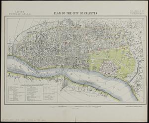
Plan of the city of Calcutta
6745.
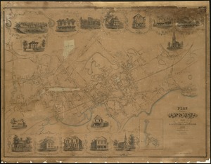
Plan of the city of Charlestown
6746.
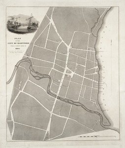
Plan of the city of Hartford from a survey made in 1824
6747.
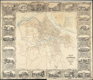
Plan of the city of Lowell, Massachusetts
6748.
Plan of the city of Lynn Mass. from actual surveys
6749.
Plan of the city of Meriden, New Haven Co., Conn. from actual surveys
6750.
Plan of the city of New Haven, New Haven, Conn.
6751.
Plan of the city of New York
6752.
Plan of the city of New York : showing the made and swamp land
6753.
Plan of the city of New York, 1791
6754.
A plan of the city of New York from an actual survey
6755.
A plan of the city of New York from an actual survey
6756.
A plan of the city of New York from an actual survey
6757.
A plan of the city of New-York
6758.
A plan of the city of New-York & its environs to Greenwich, on the North or Hudsons River, and to Crown Point, on the East or...
6759.
Plan of the city of Norwich, New London County, Connt
6760.
A plan of the city of Philadelphia, the capital of Pennsylvania, from an actual survey
‹ Prev
Next ›
1
2
…
334
335
336
337
338
339
340
341
342
…
447
448
![Plan of the city intended for the permanent seat of the government of t[he] United States](https://bpldcassets.blob.core.windows.net/derivatives/images/commonwealth:4m90f381c/image_thumbnail_300.jpg)


![A plan of the city of New-York & its environs to Greenwich, on the North or Hudsons River, and to Crown Point, on the East or Sound River, shewing the several streets, publick buildings, docks, fort & battery, with the true form & course of the commanding grounds, with and without the town : survey'd in the winter, 1775 [i.e. 1766]](https://bpldcassets.blob.core.windows.net/derivatives/images/commonwealth:6t053q479/image_thumbnail_300.jpg)

