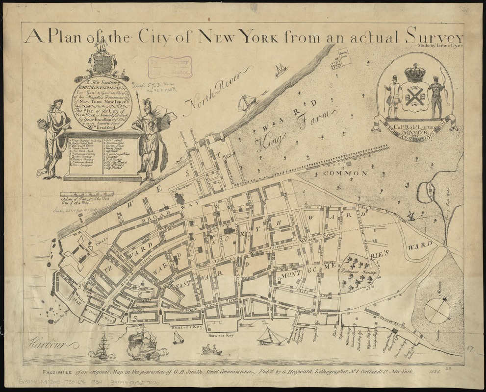
A plan of the city of New York from an actual survey
Item Information
- Title:
- A plan of the city of New York from an actual survey
- Commonly known as :
- Bradford Plan
- Creator:
- Lyne, James.
- Name on Item:
-
made by James Lyne.
- Date:
-
1834
- Format:
-
Maps/Atlases
- Location:
-
Boston Public Library
Norman B. Leventhal Map & Education Center - Collection (local):
-
Norman B. Leventhal Map & Education Center Collection
- Subjects:
-
Manhattan (New York, N.Y.)--Maps--Early works to 1800--Facsimiles
- Places:
-
New YorkNew YorkManhattan
- Extent:
- 1 map ; 44 x 56 cm.
- Terms of Use:
-
No known copyright restrictions.
No known restrictions on use.
- Publisher:
-
New-York :
Pubed. by G. Hayward
- Scale:
-
Scale [ca. 1:3,000]
- Language:
-
English
- Notes:
-
Facsimile of an original map [New York : Wm. Bradford, 1728] in the possession of G.B. Smith, Street Commissioner.
Shows wards, streets, and public buildings.
Oriented with north to the upper right.
Includes references to points of interest.
Cartouche: To his excellency John Montgomerie, Esq. Capt. Genl. & Gov. in Chief of his Majestis provinces of New York New Jersey this plan of the city of New York is humbly dedic'd by Your Excellancy's obet & most humble servt, Wm. Bradford.
Seal at upper right: Col. Robt. Lurting, Mayor. 1728.
- Identifier:
-
06_01_010767
- Call #:
-
G3804.N4:2M3 1730 .L96 1834
- Barcode:
-
39999065677070