Toggle navigation
LMEC Home
Exhibitions
Georeferencing
Tools for Teachers
Collections
My Favorites
Sign Up / Log In
Search
Search the map portal
Map Collection
Map Collection
Map Sets
Search
Search
Search for
Search In
All Fields
Creator
Title
Subject
Place
Search All Digital Collections
Advanced Search
8945 Results
My Search
Start Over
More Like
commonwealth:wd3768095
Remove constraint More Like: commonwealth:wd3768095
Filter your Search
Place
North and Central America
6,176
United States
5,080
Massachusetts
2,216
Europe
1,396
Suffolk (county)
1,210
Boston
1,183
Canada
450
Asia
438
more
Place
»
Topic
Boston (Mass.)--Maps
752
United States--Maps
282
Massachusetts--Maps
235
Real property--Massachusetts--Boston--Maps
195
City planning--Massachusetts--Boston--Maps
158
Landowners--Massachusetts--Boston--Maps
142
New England--Maps
106
North America--Maps--Early works to 1800
103
more
Topic
»
Date
Date range begin
–
Date range end
Current results range from
1482
to
2023
View distribution
Creator
United States. Hydrographic Office
595
Boston Redevelopment Authority
162
O.H. Bailey & Co
148
Des Barres, Joseph F. W. (Joseph Frederick Wallet), 1722-1824
124
United States. Post Office Dept
120
Ptolemy, 2nd cent
100
Walling, Henry Francis, 1825-1888
95
Geological Survey (U.S.)
92
more
Creator
»
Format
Maps/Atlases
8,884
Manuscripts
217
Prints
56
Books
36
Objects/Artifacts
10
Drawings/Illustrations
8
Posters
6
Ephemera
1
Georeferenced
Yes
894
No
8,051
Collection
Norman B. Leventhal Map & Education Center Collection
8,772
Boston and New England Maps
2,411
Urban Maps
2,143
Maritime Charts and Atlases
1,087
American Revolutionary War-Era Maps
662
Boston Redevelopment Authority Collection
195
Mapping Boston Collection
29
William L. Clements Library Collection
23
more
Collection
»
Available to use
No known restrictions
8,708
Creative Commons license
80
Search Constraints
Sort by relevance
relevance
title
date (asc)
date (desc)
Number of results to display per page
20 per page
10
per page
20
per page
50
per page
100
per page
View results as:
grid view
map view
Search Results
6701.
Plan of sections of 1, 2 & 3, East Boston
6702.
Plan of Sesuit Harbor in East Dennis : under chapter 32 resolves of 1907
6703.
Plan of Shakspeare's birth-place
6704.
Plan of Sherburne Bluffs, Nantucket, Mass
6705.
Plan of Sorrento, Maine
6706.
Plan of South Boston
6707.
A plan of South Boston and the owners lands, and the roads, taken from the original plan now in keeping, being the same plan...
6708.
Plan of Springfield
6709.
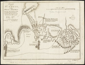
Plan of St. Lucia, in the West Indies : shewing the positions of the English and French forces with the attacks made at its...
6710.
Plan of Stephen W. and Francis Jackson's farm in Newton, 6 1/2 miles from Boston
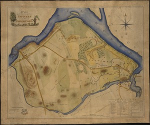
6711.
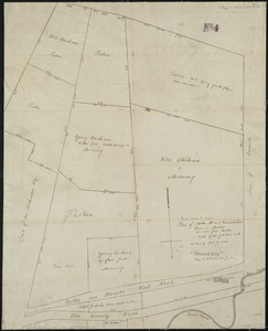
A plan of sundry farms etc. at Patucket in the town of Chelmsford
6712.
A plan of the action at Breeds Hill, on the 17th of June 1775 : between the American forces and the British troops :...
6713.
A plan of the action at Bunkers Hill on the 17th of June 1775 between His Majesty's troops, under the command of Major General...
6714.
A plan of the action at Bunkers Hill on the 17th of June 1775 between His Majesty's troops, under the command of Major General...
6715.
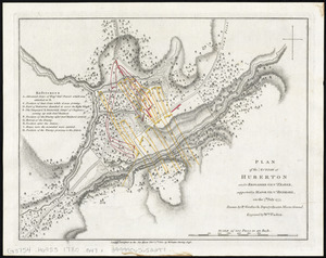
Plan of the action at Huberton under Brigadier Genl. Frazer, supported by Major Genl. Reidesel, on the 7th July 1777
6716.
Plan of the ancient burial place Newton
6717.
Plan of the Arnold Arboretum Jamaica Plain Mass
6718.
Plan of the attack against Basseterre on the island of Guadeloupe by a squadron of his Majesty's ships of war commanded by...
6719.
Plan of the attack against Fort Louis now Fort George, at Point à Pitre on the island of Guadaloupe : by a squadron of His...
6720.
A plan of the attack of Fort Sulivan, near Charles Town in South Carolina : by a squadron of His Majesty's ships, on the 28th...
‹ Prev
Next ›
1
2
…
332
333
334
335
336
337
338
339
340
…
447
448