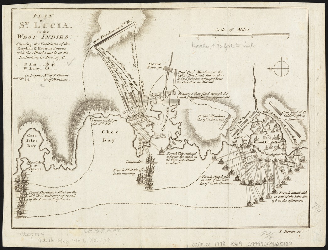
Plan of St. Lucia, in the West Indies : shewing the positions of the English and French forces with the attacks made at its reduction in Decr. 1778
This map is also available in American Revolutionary Geographies Online (ARGO), a collections portal especially built for material relating to the American Revolutionary War Era. Visit ARGO to learn more about this item and explore the historical geography of North America in the late eighteenth century.
Item Information
- Title:
- Plan of St. Lucia, in the West Indies : shewing the positions of the English and French forces with the attacks made at its reduction in Decr. 1778
- Title (alt.):
-
Plan of Saint Lucia, in the West Indies
- Title (uniform):
-
Gentleman's magazine (London, England)
- Creator:
- Bowen, Thomas, d. 1790
- Name on Item:
-
T. Bowen sct.
- Date:
-
[1779]
- Format:
-
Maps/Atlases
- Location:
-
Boston Public Library
Norman B. Leventhal Map & Education Center - Collection (local):
-
Norman B. Leventhal Map & Education Center Collection
- Subjects:
-
Saint Lucia, Battle of, Saint Lucia, 1778--Maps--Early works to 1800
Saint Lucia--History, Military--Maps--Early works to 1800
Saint Lucia--Maps--Early works to 1800
- Places:
-
Saint Lucia
- Extent:
- 1 map ; 19 x 26 cm.
- Terms of Use:
-
No known copyright restrictions.
No known restrictions on use.
- Publisher:
-
London :
Gentleman's magazine
- Scale:
-
Scale [ca. 1:51,000]
- Language:
-
English
- Notes:
-
Relief shown by hachures.
Oriented with north to the left.
Shows attacks made on Dec. 13-Dec. 16, 1778.
Includes descriptive text.
From: The gentleman's magazine, April 1779.
- Notes (date):
-
This date is inferred.
- Identifier:
-
06_01_010496
- Call #:
-
G5111.S1 1778 .B69
- Barcode:
-
39999059025187
- LCCN:
-
74696150