Toggle navigation
LMEC Home
Exhibitions
Georeferencing
Tools for Teachers
Collections
My Favorites
Sign Up / Log In
Search
Search the map portal
Map Collection
Map Collection
Map Sets
Search
Search
Search for
Search In
All Fields
Creator
Title
Subject
Place
Search All Digital Collections
Advanced Search
9058 Results
My Search
Start Over
More Like
commonwealth:wd376807m
Remove constraint More Like: commonwealth:wd376807m
Filter your Search
Place
North and Central America
6,285
United States
5,168
Massachusetts
2,115
Europe
1,396
Suffolk (county)
1,103
Boston
1,071
Canada
463
Asia
438
more
Place
»
Topic
Boston (Mass.)--Maps
594
United States--History--Revolution, 1775-1783--Maps
330
United States--Maps
283
Real property--Massachusetts--Boston--Maps
175
Massachusetts--Maps
163
Landowners--Massachusetts--Boston--Maps
133
New England--Maps
103
North America--Maps--Early works to 1800
103
more
Topic
»
Date
Date range begin
–
Date range end
Current results range from
1482
to
2023
View distribution
Creator
United States. Hydrographic Office
595
O.H. Bailey & Co
148
Des Barres, Joseph F. W. (Joseph Frederick Wallet), 1722-1824
124
United States. Post Office Dept
120
Ptolemy, 2nd cent
100
Walling, Henry Francis, 1825-1888
94
Geological Survey (U.S.)
86
Jefferys, Thomas, -1771
86
more
Creator
»
Format
Maps/Atlases
8,990
Manuscripts
227
Prints
56
Books
36
Drawings/Illustrations
16
Objects/Artifacts
10
Posters
5
Georeferenced
Yes
877
No
8,181
Collection
Norman B. Leventhal Map & Education Center Collection
8,711
Boston and New England Maps
2,248
Urban Maps
2,027
Maritime Charts and Atlases
1,083
American Revolutionary War-Era Maps
978
William L. Clements Library Collection
305
Boston Redevelopment Authority Collection
87
Richard H. Brown Revolutionary War Map Collection at Mount Vernon
19
more
Collection
»
Available to use
No known restrictions
8,558
Creative Commons license
86
Search Constraints
Sort by relevance
relevance
title
date (asc)
date (desc)
Number of results to display per page
20 per page
10
per page
20
per page
50
per page
100
per page
View results as:
grid view
map view
Search Results
7841.
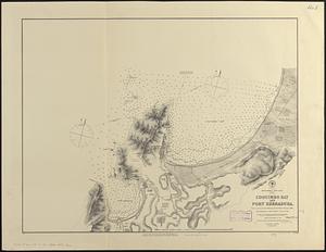
South America--west coast, Chile, Coquimbo Bay and Port Herradura : from a survey by the officers of H.B.M.S. Nassau, 1868 ;...
7842.
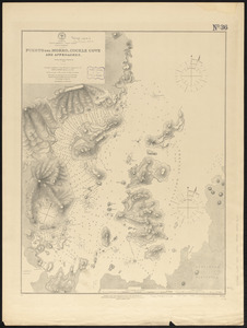
South America--west coast, Gulf of Trinidad, Puerto del Morro, Cockle Cove and approaches : from a British survey in 1879
7843.
South America--west coast, Patagonia, Concepcion Channel
7844.
South America--west coast, Patagonia, harbors and anchorages in Trinidad Channel
7845.
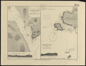
South America--west coast, ports on the coast of Chile : republication of the British Admty. charts nos. 809 & 1312
7846.
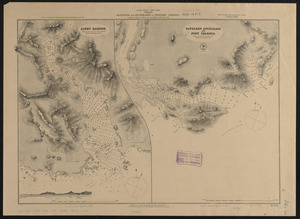
South America--west coast--Patagonia, anchorages in Wide Channel and Indian Reach : from Chilean partial surveys in 1879
7847.
South Atlantic Ocean, Island of Ascension : republication of British Admiralty chart no. 1691, corrected to 1874
7848.
South Atlantic Ocean, the South Shetland and South Orkney Islands, with the tracks of the several discoverers, 1819 to 1843 :...
7849.
South Bay and Savin Hill parks : Dorchester district
7850.
South Boston
7851.
South Britain or England & Wales : drawn from several surveys &c. on the new projection ; corrected from astronomical...
7852.
South Carolina
7853.
South coast of Newfoundland, Great Miquelon Island, Miquelon Road : from a French survey in 1841
7854.
South coast of Newfoundland, St. Pierre Island, St. Pierre Harbor : from a French survey in 1841, with additions in 1881
7855.
South Cove, in Boston
7856.
The South Cove territory, comprising every part which is coloured on this map
7857.
The south east coast of Cape Breton Island
7858.
The south east coast of the island of St. John : surveyed under the direction of the Right Honourable the Lords of Trade and...
7859.
South Easton, Massachusetts : 1888
7860.
South end of Lake Huron and head of the St. Clair River
‹ Prev
Next ›
1
2
…
389
390
391
392
393
394
395
396
397
…
452
453