Toggle navigation
LMEC Home
Exhibitions
Georeferencing
Tools for Teachers
Collections
My Favorites
Sign Up / Log In
Search
Search the map portal
Map Collection
Map Collection
Map Sets
Search
Search
Search for
Search In
All Fields
Creator
Title
Subject
Place
Search All Digital Collections
Advanced Search
8669 Results
My Search
Start Over
More Like
commonwealth:w9505s603
Remove constraint More Like: commonwealth:w9505s603
Filter your Search
Place
North and Central America
5,881
United States
4,812
Massachusetts
2,052
Europe
1,359
Suffolk (county)
1,034
Boston
1,007
Canada
464
Asia
422
more
Place
»
Topic
Boston (Mass.)--Maps
577
United States--Maps
273
North America--Maps--Early works to 1800
180
Real property--Massachusetts--Boston--Maps
174
Massachusetts--Maps
160
Landowners--Massachusetts--Boston--Maps
132
New England--Maps
99
Europe--Maps
78
more
Topic
»
Date
Date range begin
–
Date range end
Current results range from
1482
to
2023
View distribution
Creator
United States. Hydrographic Office
594
O.H. Bailey & Co
148
Des Barres, Joseph F. W. (Joseph Frederick Wallet), 1722-1824
123
United States. Post Office Dept
120
Ptolemy, 2nd cent
100
Walling, Henry Francis, 1825-1888
94
Jefferys, Thomas, -1771
91
Geological Survey (U.S.)
86
more
Creator
»
Format
Maps/Atlases
8,610
Manuscripts
219
Prints
56
Books
36
Objects/Artifacts
10
Drawings/Illustrations
8
Posters
4
Georeferenced
Yes
874
No
7,795
Collection
Norman B. Leventhal Map & Education Center Collection
8,560
Boston and New England Maps
2,205
Urban Maps
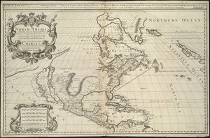
1,936
Maritime Charts and Atlases
1,081
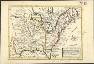
American Revolutionary War-Era Maps
718
Boston Redevelopment Authority Collection
87
New York Public Library Collection
46
Richard H. Brown Revolutionary War Map Collection at Mount Vernon
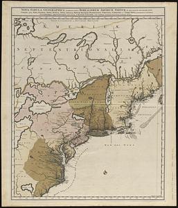
28
more
Collection
»
Available to use
No known restrictions
8,413
Creative Commons license
139
Search Constraints
Sort by relevance
relevance
title
date (asc)
date (desc)
Number of results to display per page
20 per page
10
per page
20
per page
50
per page
100
per page
View results as:
grid view
map view
Search Results
121.
A new map of ye north parts of America claimed by France under ye names of Louisiana, Mississipi, Canada & new France with the...
122.
Nieuwe kaart van de Grootbrittannische volkplantingen in Noord America : waar in tevens de Fransche bezittingen en de Landen,...
123.
North America : performed under the patronage of Louis Duke of Orleans, First Prince of the Blood
124.
North America : from the French of Mr. d'Anville, improved with the back settlements of Virginia and course of Ohio,...
125.
North America : corrected from the observation communicated to the Royal Society at London and the Royal Academy at Paris
126.
North America
127.
North America
128.
North America
129.
North America divided into its III principall parts : 1st English part viz. English Empire containing ye Articklands near...
130.
North America, divided into its principall parts where are distinguished the severall states which belong to the English,...
131.
North America, drawn from the best authorities
132.
North America from the French of Mr. D'Anville, improved with the back settlements of Virginia and course of Ohio, illustrated...
133.
The north part of America : conteyning Newfoundland, new England, Virginia, Florida, new Spaine, and Noua Francia wth ye rich...
134.
Noua et accurata totius Americae tabula
135.
Le Nouveau Mexique et la Floride : tirées de diverses cartes, et relations
136.
Nova tabula geographica complectens borealiorem Americae partem : in qua exacte delineatae sunt Canada sive Nova Francia, Nova...
137.
Nova tabula geographica complectens borealiorem Americæ partem : in qua exacte delineatæ sunt Canada sive Nova Francia, Nova...
138.
Novissima et accuratissima totius Americae descriptio
139.
Partie de l'Amerique Septentrionale, qui comprend le Canada, la Louisiane, le Labrador, le Groenland, la Nouvelle Angleterre,...
140.
Paskaerte van Nova Granada en t'Eylandt California
‹ Prev
Next ›
1
2
3
4
5
6
7
8
9
10
11
…
433
434