Toggle navigation
LMEC Home
Exhibitions
Georeferencing
Tools for Teachers
Collections
My Favorites
Sign Up / Log In
Search
Search the map portal
Map Collection
Map Collection
Map Sets
Search
Search
Search for
Search In
All Fields
Creator
Title
Subject
Place
Search All Digital Collections
Advanced Search
8782 Results
My Search
Start Over
More Like
commonwealth:w9505r615
Remove constraint More Like: commonwealth:w9505r615
Filter your Search
Place
North and Central America
5,985
United States
4,919
Massachusetts
2,079
Europe
1,396
Suffolk (county)
1,046
Boston
1,019
Canada
469
Asia
438
more
Place
»
Topic
Boston (Mass.)--Maps
586
United States--Maps
282
Real property--Massachusetts--Boston--Maps
175
Massachusetts--Maps
162
Landowners--Massachusetts--Boston--Maps
133
North America--Maps--Early works to 1800
113
United States--Maps--Early works to 1800
103
New England--Maps
102
more
Topic
»
Date
Date range begin
–
Date range end
Current results range from
1482
to
2023
View distribution
Creator
United States. Hydrographic Office
595
O.H. Bailey & Co
148
Des Barres, Joseph F. W. (Joseph Frederick Wallet), 1722-1824
123
United States. Post Office Dept
120
Ptolemy, 2nd cent
100
Walling, Henry Francis, 1825-1888
94
Jefferys, Thomas, -1771
89
Geological Survey (U.S.)
86
more
Creator
»
Format
Maps/Atlases
8,722
Manuscripts
218
Prints
56
Books
36
Objects/Artifacts
10
Drawings/Illustrations
8
Posters
5
Georeferenced
Yes
872
No
7,910
Collection
Norman B. Leventhal Map & Education Center Collection
8,696
Boston and New England Maps
2,233
Urban Maps
2,023
Maritime Charts and Atlases
1,083
American Revolutionary War-Era Maps
701
Boston Redevelopment Authority Collection
87
MacLean Collection Map Library
47
New York Public Library Collection
15
more
Collection
»
Available to use
No known restrictions
8,556
Creative Commons license
80
Search Constraints
Sort by relevance
relevance
title
date (asc)
date (desc)
Number of results to display per page
20 per page
10
per page
20
per page
50
per page
100
per page
View results as:
grid view
map view
Search Results
81.
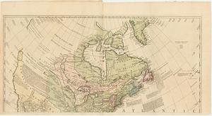
A new map of North America
82.
A new map of the United States of North America with the British dominions on that continent &c
83.
Partie de l'Amérique septentrionale, qui comprend le cours de l'Ohio, la Nlle. Angleterre, la Nlle York, le New Jersey, la...
84.
States of America, drawn from the best authorities
85.
The United States of America with the British possessions of Canada, Nova Scotia, & of Newfoundland, divided with the French :...
86.
The United States of America with the British possessions of Canada, Nova Scotia, New Brunswick and Newfoundland divided with...
87.
The United States of North America : with the British & Spanish territories according to the treaty
88.
The United States of North America : with the British territories and those of Spain according to the treaty of 1784
89.
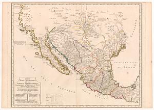
Nuevo mapa geografico de la America Septentrional, perteneciente al virreynato de Mexico dedicado à los sabios miembros de la...
90.
Carte du Cap Franc̨ois de Saint Domingue, de l'isle de Cuba, de la Jamaique avec le canal de Bahama, l'entrée du fleuve St....
91.
Chart of South America, comprehending the West Indies, with the adjacent islands, in the Southern Ocean, and South Sea
92.
Chart of the Atlantic Ocean, with the British, French, & Spanish settlements in North America, and the West Indies : as also on...
93.
Copia, del mapa de las Indias Occidentales : y del manifiesto que presentò D. Thomas Southuel, à la Superioridad, en el año...
94.
Descripcion de la costa de Tierra Firme desde el Cavo de la Agusa hasta la Barra de Palmas diga de la Trinidad : Con todas las...
95.
A general map of North America; in which is express'd the several new roads, forts, engagements, &c. taken from actual surveys...
96.
A new and correct map of North America; with the West India Islands : divided according to the last treaty of peace, concluded...
97.
A new and correct map of the West Indies drawn from the best authorities
98.
Port de St. Augustin -- Port de la Providence -- La Havane dans l'isle de Cuba -- Baye de Sn. Iago dans l'isle de Cuba -- Port...
99.
Rade et port de Plaisance -- Le Port d'Anapolis dans l'Acadie -- Port de Boston dans la Nouvlle. Angleterre
100.
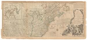
An accurate map of the English colonies in North America, bordering on the river Ohio
‹ Prev
Next ›
1
2
3
4
5
6
7
8
9
…
439
440