Toggle navigation
LMEC Home
Exhibitions
Georeferencing
Tools for Teachers
Collections
My Favorites
Sign Up / Log In
Search
Search the map portal
Map Collection
Map Collection
Map Sets
Search
Search
Search for
Search In
All Fields
Creator
Title
Subject
Place
Search All Digital Collections
Advanced Search
8832 Results
My Search
Start Over
More Like
commonwealth:w9505r51x
Remove constraint More Like: commonwealth:w9505r51x
Filter your Search
Place
North and Central America
6,009
United States
4,859
Massachusetts
2,079
Europe
1,396
Suffolk (county)
1,046
Boston
1,019
Canada
454
Asia
441
more
Place
»
Topic
Boston (Mass.)--Maps
586
United States--Maps
282
North America--Maps--Early works to 1800
240
Real property--Massachusetts--Boston--Maps
175
Massachusetts--Maps
162
Landowners--Massachusetts--Boston--Maps
133
New England--Maps
102
Europe--Maps
79
more
Topic
»
Date
Date range begin
–
Date range end
Current results range from
1482
to
2023
View distribution
Creator
United States. Hydrographic Office
595
O.H. Bailey & Co
148
Des Barres, Joseph F. W. (Joseph Frederick Wallet), 1722-1824
123
United States. Post Office Dept
120
Ptolemy, 2nd cent
100
Walling, Henry Francis, 1825-1888
94
Jefferys, Thomas, -1771
92
Sayer, Robert, 1725-1794
87
more
Creator
»
Format
Maps/Atlases
8,772
Manuscripts
217
Prints
56
Books
36
Objects/Artifacts
10
Drawings/Illustrations
8
Posters
5
Georeferenced
Yes
872
No
7,960
Collection
Norman B. Leventhal Map & Education Center Collection
8,704
Boston and New England Maps
2,234
Urban Maps
2,023
Maritime Charts and Atlases
1,083
American Revolutionary War-Era Maps
739
Boston Redevelopment Authority Collection
87
MacLean Collection Map Library
59
New York Public Library Collection
32
more
Collection
»
Available to use
No known restrictions
8,556
Creative Commons license
111
Search Constraints
Sort by relevance
relevance
title
date (asc)
date (desc)
Number of results to display per page
20 per page
10
per page
20
per page
50
per page
100
per page
View results as:
grid view
map view
Search Results
3161.
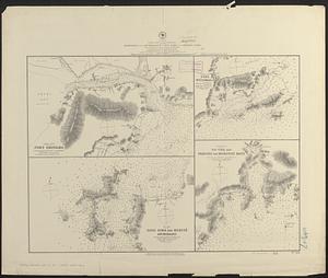
Japan, Seto Uchi or Inland Sea, harbors and anchorages in Iyo Nada and Harima Nada : from French government surveys in...
3162.
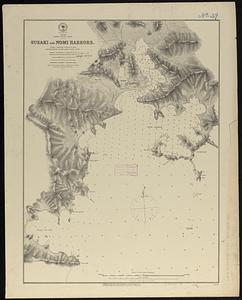
Japan, Sikok-- south coast, Susaki and Nomi Harbors : from a British survey in 1872 ; republication of Brit. Admty. chart no. 995
3163.
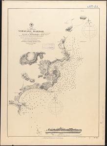
Japan, south coast of Kiusiu, Yamagawa Harbor in the Gulf of Kagosima : from a survey by Japanese naval officers in 1872
3164.
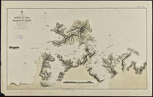
Japan, south coast of Nipon, Kii Channel to Owasi Bay : from Brit. surveys in 1874 ; republication of Brit. Admty. chart no. 951
3165.
Japan, the target : a pictorial Jap-map
3166.
Japan, west coast of Kiusiu, the northern entrance of Hirado-no-Seto (Spex Strait) with the harbor of Yebukuro-no-Minato
3167.
Japanese fishing, areas and seasons
3168.
Japan-Yezo Id., e. coast, Akishi Bay : republished from the Brt. Admty. chart no. 992, corrected to 1873
3169.
Java and Madoera : Indonesian ethnic groups, elementary education, and Christian missions
3170.
Java and Madoera principal estate regions showing major products
3171.
Jefferson County, Wis.
3172.
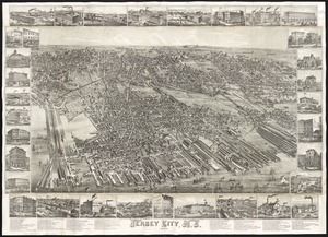
Jersey City, N.J : 1883
3173.
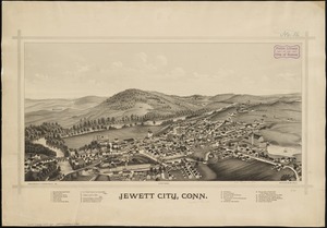
Jewett City, Conn
3174.
J.H. Colton's topographical map of North and South Carolina : a large portion of Georgia & part of adjoining states
3175.
J.H. Colton's Topographical map of seat of war in Virginia, Maryland, &c
3176.
J.M.E. Riedel's new street number guide map of Fort Wayne
3177.
John Hancock office and parking garage complex, Boston, Massachusetts
3178.
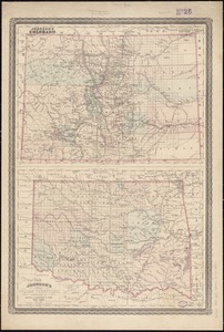
Johnson's Colorado ; Johnson's Indian Territory
3179.
Johnson's map of New York and the adjacent cities
3180.
Johnson's Massachusetts Connecticut and Rhode Island
‹ Prev
Next ›
1
2
…
155
156
157
158
159
160
161
162
163
…
441
442