Toggle navigation
LMEC Home
Exhibitions
Georeferencing
Tools for Teachers
Collections
My Favorites
Sign Up / Log In
Search
Search the map portal
Map Collection
Map Collection
Map Sets
Search
Search
Search for
Search In
All Fields
Creator
Title
Subject
Place
Search All Digital Collections
Advanced Search
8643 Results
My Search
Start Over
More Like
commonwealth:w9505r437
Remove constraint More Like: commonwealth:w9505r437
Filter your Search
Place
North and Central America
5,880
United States
4,799
Massachusetts
2,056
Europe
1,359
Suffolk (county)
1,038
Boston
1,011
Canada
453
Asia
422
more
Place
»
Topic
Boston (Mass.)--Maps
580
United States--Maps
278
North America--Maps--Early works to 1800
180
Real property--Massachusetts--Boston--Maps
175
Massachusetts--Maps
160
Landowners--Massachusetts--Boston--Maps
133
New England--Maps
101
Europe--Maps
78
more
Topic
»
Date
Date range begin
–
Date range end
Current results range from
1482
to
2023
View distribution
Creator
United States. Hydrographic Office
594
O.H. Bailey & Co
148
Des Barres, Joseph F. W. (Joseph Frederick Wallet), 1722-1824
123
United States. Post Office Dept
120
Ptolemy, 2nd cent
100
Walling, Henry Francis, 1825-1888
94
Jefferys, Thomas, -1771
90
Geological Survey (U.S.)
86
more
Creator
»
Format
Maps/Atlases
8,584
Manuscripts
217
Prints
56
Books
36
Objects/Artifacts
10
Drawings/Illustrations
8
Posters
4
Georeferenced
Yes
872
No
7,771
Collection
Norman B. Leventhal Map & Education Center Collection
8,574
Boston and New England Maps
2,211
Urban Maps
1,940
Maritime Charts and Atlases
1,081
American Revolutionary War-Era Maps
679
Boston Redevelopment Authority Collection
87
New York Public Library Collection
32
Richard H. Brown Revolutionary War Map Collection at Mount Vernon
18
more
Collection
»
Available to use
No known restrictions
8,427
Creative Commons license
110
Search Constraints
Sort by relevance
relevance
title
date (asc)
date (desc)
Number of results to display per page
20 per page
10
per page
20
per page
50
per page
100
per page
View results as:
grid view
map view
Search Results
3021.
J. Schedler's relief map of Boston and environs
3022.
J. Schedler's relief map of the White Mountains, N.H
3023.
Jackson County, Wis.
3024.
Jamaica
3025.
Jamaica, from the latest surveys
3026.
Jamaica Park and Bussey Farm Parkway : West Roxbury district
3027.
Jamaica Plain, Massachusetts : Ward 23, City of Boston, 1891
3028.
Jamaica Plain view of the world
3029.
Jamaica Pond master plan
3030.
James Hayes Park
3031.
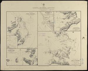
Japan - n.w. coast of Nipon, Nanao Harbors : south harbor, surveyed by Commander C.J. Bullock and the officers of H.M.S....
3032.
Japan, anchorages in the Seto-Uchi or Inland Sea
3033.
Japan, anchorages on the coasts of Yezo Id
3034.
Japan and its relation to the territory bordering on the Pacific Ocean
3035.
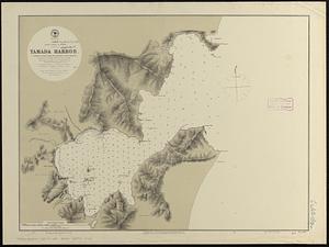
Japan, east coast of Nipon, Yamada Harbor
3036.
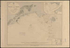
Japan, Gulf of Ösaka, Hiogo and Ösaka : compiled from British and French surveys to 1878
3037.
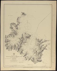
Japan, Gulf of Yezo, Ura-No-Go-Ura and Yokoska Bays : from a French survey in 1870
3038.
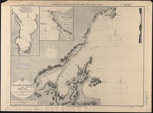
Japan, harbors and anchorages on the north-west coast of Nipon
3039.
Japan, harbors in Kii Channel and Isumi Strait : from British surveys in 1861 with auditions in 1866-7 ; republication of Brit....
3040.
Japan-- Inland Sea, channels between Misima Nada and Bingo Nada : republication of Brit. Admlty. chart no. 132, corrected to 1874
‹ Prev
Next ›
1
2
…
148
149
150
151
152
153
154
155
156
…
432
433