Jamaica Plain, Massachusetts : Ward 23, City of Boston, 1891
Item Information
- Title:
- Jamaica Plain, Massachusetts : Ward 23, City of Boston, 1891
- Description:
-
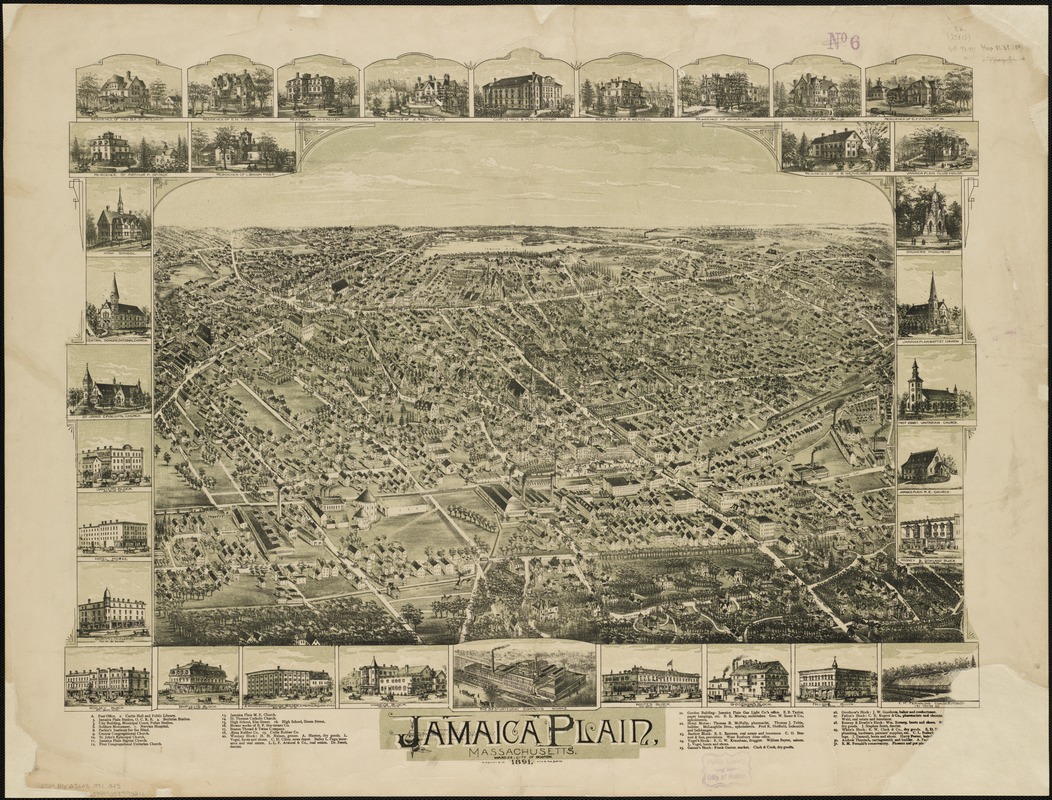
The neighborhood of Jamaica Plain is located in the northern part of the town of West Roxbury, which was annexed by Boston in 1874. During the early 19th century, Jamaica Plain was known as a summer resort for wealthy Bostonians, because of its proximity to Jamaica Pond and the wooded hillsides. As Boston expanded from its original peninsular site to the Roxbury mainland, Jamaica Plain developed into a street car suburb and an industrial community in its own right. Viewed from the southeast looking northwestward, with Jamaica Pond and Brookline on the horizon, this image emphasizes the village's industrial base. The B.F. Sturtevant Company, a manufacturer of fans and blowers, was placed both in the drawing's center foreground and was in the bottom center marginal illustration. Three other factories, which produced rubber goods, thread, and twine, also appear in the foreground because they are near the railroad tracks which cross the lower portion of the drawing. Despite this emphasis on the neighborhood's industries, the marginal illustrations depict ten commercial blocks and stores, five churches, several other public buildings, and eleven private residences, also highlighting the residential nature of this community. Placed prominently in the upper left hand corner are two insets showing the residences of Mrs. B.F. Sturtevant (whose husband died in 1890) and E.N. Foss (Sturtevants son-in-law who took over the company following the founders death). After a disastrous fire in 1901, the Sturtevant Company relocated to Hyde Park. Eugene Foss served as Governor of Massachusetts from 1911-1914.
- Creator:
- O.H. Bailey & Co
- Name on Item:
-
O.H. Bailey & Co., Lith. & Pub.
- Date:
-
1891
- Format:
-
Maps/Atlases
- Location:
-
Boston Public Library
Norman B. Leventhal Map & Education Center - Collection (local):
-
Norman B. Leventhal Map & Education Center Collection
- Subjects:
-
Jamaica Plain (Boston, Mass.)--Aerial views
Boston (Mass.)--Aerial views
- Places:
-
MassachusettsSuffolk (county)BostonJamaica Plain
- Extent:
- 1 view : col. ; 56 x 72 cm.
- Terms of Use:
-
No known copyright restrictions.
No known restrictions on use.
- Publisher:
-
Boston :
O.H. Bailey & Co.
- Scale:
-
Not drawn to scale.
- Language:
-
English
- Notes:
-
Bird's-eye view.
Includes ill.
Indexed for points of interest.
- Notes (exhibitions):
-
Exhibited: "Boston & Beyond: A Bird’s Eye View of New England " organized by the Norman B. Leventhal Map Center at the Boston Public Library, 2008.
Exhibited: "Crossing Boundaries: Art // Maps" organized by the Norman B. Leventhal Map & Education Center at the Boston Public Library, 2018-2019.
- Identifier:
-
06_01_001572
- Call #:
-
G3764.B6:2J3A3 1891 .O43
- Barcode:
-
39999058993211


