Toggle navigation
LMEC Home
Exhibitions
Georeferencing
Tools for Teachers
Collections
My Favorites
Sign Up / Log In
Search
Search the map portal
Map Collection
Map Collection
Map Sets
Search
Search
Search for
Search In
All Fields
Creator
Title
Subject
Place
Search All Digital Collections
Advanced Search
8954 Results
My Search
Start Over
More Like
commonwealth:tt44pv73k
Remove constraint More Like: commonwealth:tt44pv73k
Filter your Search
Place
North and Central America
6,185
United States
5,101
Massachusetts
2,145
Europe
1,396
Suffolk (county)
1,300
Boston
1,273
Canada
449
Asia
438
more
Place
»
Topic
Boston (Mass.)--Maps
752
United States--Maps
282
Real property--Massachusetts--Boston--Maps
253
City planning--Massachusetts--Boston--Maps
218
Landowners--Massachusetts--Boston--Maps
169
Massachusetts--Maps
166
Urban renewal--Massachusetts--Boston--Maps
124
New England--Maps
104
more
Topic
»
Date
Date range begin
–
Date range end
Current results range from
1482
to
2023
View distribution
Creator
United States. Hydrographic Office
595
Boston Redevelopment Authority
222
O.H. Bailey & Co
148
Des Barres, Joseph F. W. (Joseph Frederick Wallet), 1722-1824
124
United States. Post Office Dept
120
Ptolemy, 2nd cent
100
Walling, Henry Francis, 1825-1888
94
Geological Survey (U.S.)
87
more
Creator
»
Format
Maps/Atlases
8,894
Manuscripts
215
Prints
56
Books
36
Objects/Artifacts
10
Drawings/Illustrations
8
Posters
5
Georeferenced
Yes
885
No
8,069
Collection
Norman B. Leventhal Map & Education Center Collection
8,725
Boston and New England Maps
2,424
Urban Maps
2,207
Maritime Charts and Atlases
1,083
American Revolutionary War-Era Maps
638
Boston Redevelopment Authority Collection
256
Massachusetts Real Estate Atlases
38
Mapping Boston Collection
20
more
Collection
»
Available to use
No known restrictions
8,731
Creative Commons license
70
Search Constraints
Sort by relevance
relevance
title
date (asc)
date (desc)
Number of results to display per page
20 per page
10
per page
20
per page
50
per page
100
per page
View results as:
grid view
map view
Search Results
6041.
Northern part of Florida
6042.
Northern Philippines land utilization
6043.
Northern provinces of the United States
6044.
Northumbria, Cumberlandia, et Dunelmensis Episcopatus
6045.
Northwest Africa
6046.
Northwestern Georgia : (with portions of the adjoining states of Tennessee and Alabama) being part of the Department of the...
6047.
Northwestern part of Lake Huron
6048.
Norton, Massachusetts : 1891
6049.
Norvegia regnum divisum in suos dioeceses Nidrosiensem, Bergensem, Opsloensem, et Stavangriensem et praefecturam Bahusiae quae...
6050.
Norway, from the best authorities
6051.
Norway, west coast : from Norwegian surveys, with corrections to 1886
6052.
Norwood, Massachusetts : 1882
6053.
Noua et accurata totius Americae tabula
6054.
Nouae Africae delineatio
6055.
Noui Belgii Nouaeque Angliae nec non partis Virginiae tabula
6056.
Nouus planiglobii terrestris per utrumque polum conspectus
6057.
Le nouveau guide de l'étranger dans les 20 arrondissements de Paris
6058.
Le Nouveau Mexique et la Floride : tirées de diverses cartes, et relations
6059.
Nouveau Paris monumental : itinéraire pratique de l'etranger dans Paris
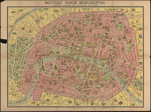
6060.
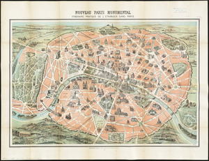
Nouveau Paris monumental : itinéraire pratique de l'étranger dans Paris
‹ Prev
Next ›
1
2
…
299
300
301
302
303
304
305
306
307
…
447
448