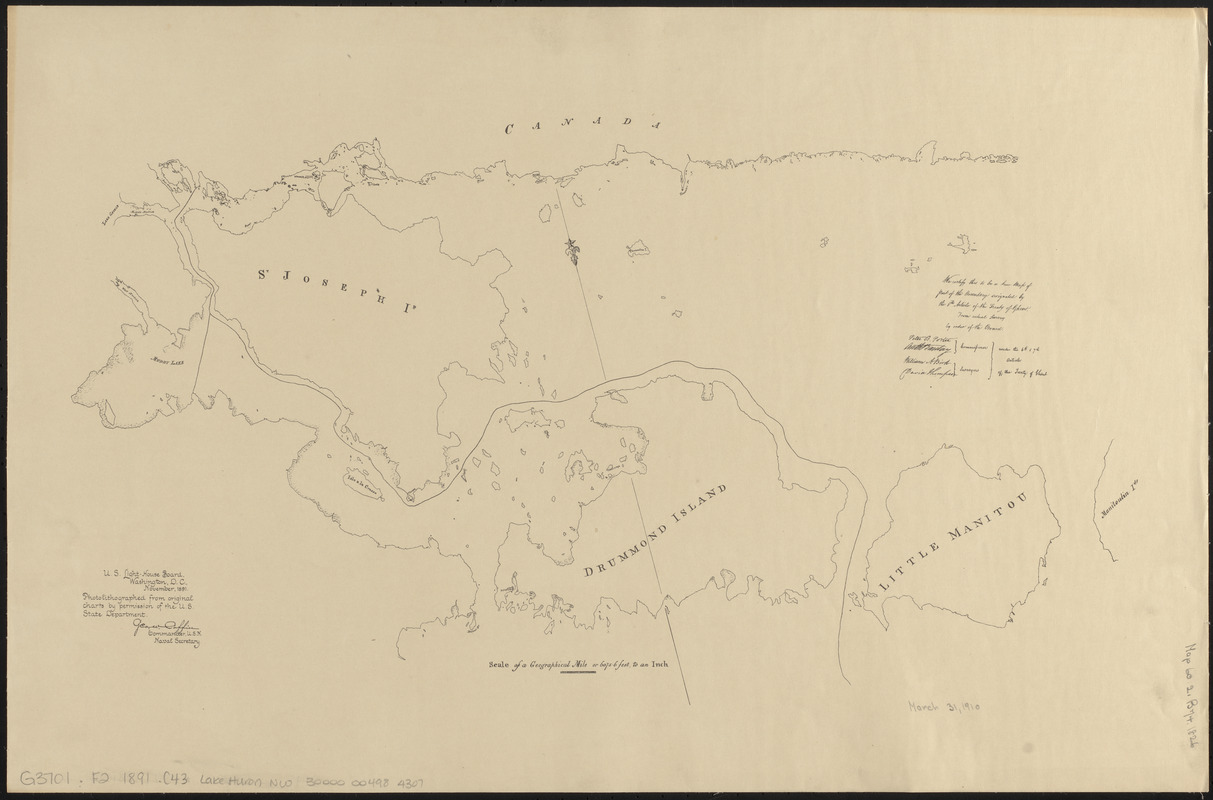
Northwestern part of Lake Huron
Item Information
- Title:
- Northwestern part of Lake Huron
- Title (uniform):
-
Charts for the international boundary between the United States and the Dominion of Canada
- Contributor:
- Barclay, Anthony, 1792-1877
- Surveyor:
- Bird, William A., 1797-1878
- Contributor:
- Porter, Peter B. (Peter Buell), 1773-1844
- Surveyor:
- Thompson, David, 1770-1857
- Publisher:
- United States. Light-House Board
- Name on Item:
-
Peter B. Porter, Anthony Barclay, commissioners ; William A. Bird, David Thompson, surveyors ; under the 6th & 7th articles of the Treaty of Ghent
- Date:
-
1891
- Format:
-
Maps/Atlases
- Location:
-
Boston Public Library
Norman B. Leventhal Map & Education Center - Collection (local):
-
Norman B. Leventhal Map & Education Center Collection
- Subjects:
-
Canada--Boundaries--United States--Maps
North Channel (Huron, Lake, Mich. and Ont.)--Maps
Huron, Lake (Mich. and Ont.)--Maps
United States--Boundaries--Canada--Maps
United States--History--War of 1812--Territorial questions--Maps
- Places:
-
CanadaOntario (province)
North Channel
- Extent:
- 1 map ; 40 x 60 cm
- Terms of Use:
-
No known copyright restrictions.
No known restrictions on use.
- Publisher:
-
Washington D.C. :
U.S. Light-House Board
- Scale:
-
Scale approximately 1:170,000
- Language:
-
English
- Notes:
-
Covers the western part of the North Channel, showing St. Joseph Island, Drummond Island and Little Manitou.
"We certify this to be a true map of part of the boundary, designated by the 6th article of the Treaty of Ghent, from actual survey by order of the Board."
"Photolithographed from original charts by permission of the U.S. State Department."
Part of a set of maps [Charts for the international boundary between the United States and the Dominion of Canada].
- Identifier:
-
06_01_008487
- Call #:
-
G3701.F2 1891 .C43 Lake Huron NW
- Barcode:
-
30000004984307