Toggle navigation
LMEC Home
Exhibitions
Georeferencing
Tools for Teachers
Collections
My Favorites
Sign Up / Log In
Search
Search the map portal
Map Collection
Map Collection
Map Sets
Search
Search
Search for
Search In
All Fields
Creator
Title
Subject
Place
Search All Digital Collections
Advanced Search
8991 Results
My Search
Start Over
More Like
commonwealth:tq57r795j
Remove constraint More Like: commonwealth:tq57r795j
Filter your Search
Place
North and Central America
6,235
United States
5,155
Massachusetts
2,136
Suffolk (county)
1,392
Europe
1,388
Boston
1,365
Canada
449
Asia
436
more
Place
»
Topic
Boston (Mass.)--Maps
671
City planning--Massachusetts--Boston--Maps
417
United States--Maps
279
Urban renewal--Massachusetts--Boston--Maps
253
Real property--Massachusetts--Boston--Maps
216
Massachusetts--Maps
161
Landowners--Massachusetts--Boston--Maps
135
North America--Maps--Early works to 1800
103
more
Topic
»
Date
Date range begin
–
Date range end
Current results range from
1482
to
2023
View distribution
Creator
United States. Hydrographic Office
595
Boston Redevelopment Authority
391
O.H. Bailey & Co
148
Des Barres, Joseph F. W. (Joseph Frederick Wallet), 1722-1824
123
United States. Post Office Dept
120
Ptolemy, 2nd cent
100
Walling, Henry Francis, 1825-1888
94
Geological Survey (U.S.)
86
more
Creator
»
Format
Maps/Atlases
8,932
Manuscripts
215
Prints
56
Books
36
Objects/Artifacts
10
Drawings/Illustrations
8
Posters
4
Georeferenced
Yes
869
No
8,122
Collection
Norman B. Leventhal Map & Education Center Collection
8,638
Boston and New England Maps
2,572
Urban Maps
2,335
Maritime Charts and Atlases
1,083
American Revolutionary War-Era Maps
616
Boston Redevelopment Authority Collection
439
Available to use
No known restrictions
8,849
Creative Commons license
47
Search Constraints
Sort by relevance
relevance
title
date (asc)
date (desc)
Number of results to display per page
20 per page
10
per page
20
per page
50
per page
100
per page
View results as:
grid view
map view
Search Results
281.
Illustrative re-use site plan for the regional core
282.
Illustrative site plan : Government Center
283.
Index to planning districts
284.
Inner belt, Southwest Expressway
285.
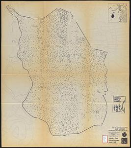
Jamaica Plain urban renewal area r-49 : building conditions
286.
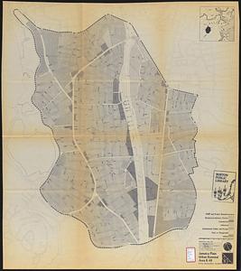
Jamaica Plain urban renewal area r-49 : existing population density
287.
Jamaica Plain urban renewal area r-49 : existing and proposed community facilities
288.
Jamaica Plain urban renewal area r-49 : proposed land use
289.
Jamaica Plain urban renewal area r-49 : existing land use
290.
Jamaica Plain urban renewal area r-49 : proposed circulation
291.
Jamaica Plain urban renewal area r-49 : existing circulation
292.
Jamaica Plain urban renewal area r-49 : proposed treatment and title I projects
293.
Locality map
294.
Long Wharf DEM/BRA master plan : master plan scheme
295.
Long Wharf DEM/BRA master plan : proposed dredging scheme
296.
Long Wharf phase II illustrative plan
297.
Longwood Medical Area
298.
Map of Boston naval shipyard, Boston, Mass. showing conditions on Jan. 1, 1966
299.
Marketplace Center : topographical survey plan
300.
Mass pike air rights study
‹ Prev
Next ›
1
2
…
11
12
13
14
15
16
17
18
19
…
449
450